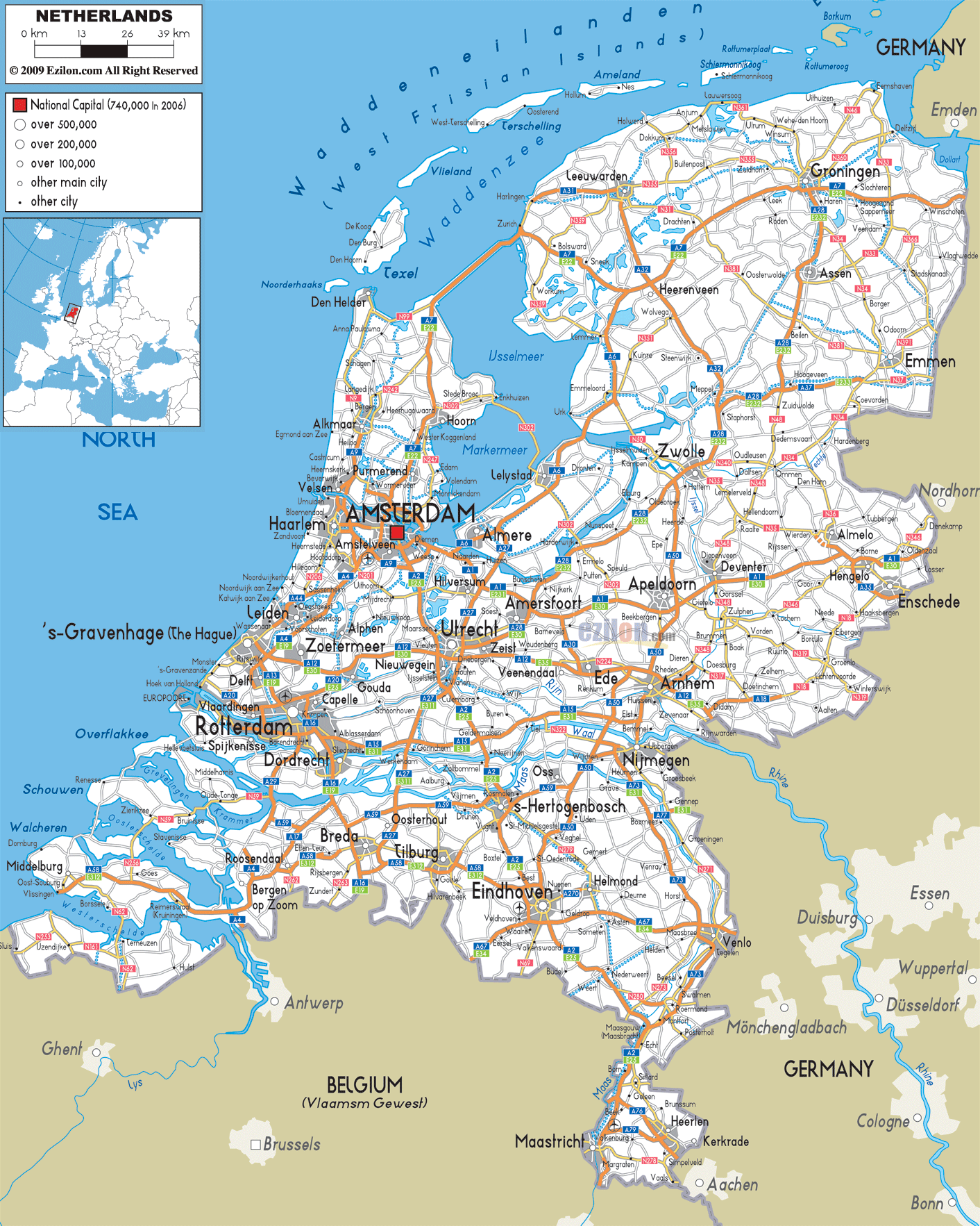

Description: Detailed clear large road map of Netherlands with road routes from cities to towns, road intersections / exit roads in regions, provinces, prefectures, also with routes leading to neighboring countries.
 Roads in the Netherlands are very dense extensive road network connecting various cities, towns and villages around the country.
The roads are classified into national roads, provincial and municipality roads with motorways and expressways. Car drivers in Netherlands are expected to drive on the right-hand side of the road and then overtake from the left side of the road.
Roads in The North Netherlands A7 E22 is a motorway and an expressway from the border with Germany passed through Groningen, intersecting to a road A32 that leads to Heerenveen, A7 still continued to Sneak, Bolsward and to Zurich, Friesland were it connects to N99 exit to Den Helder. A7 E22 continued down to Wester Koggenland, Purmerend and all the way to the city of Amsterdam.
Other roads such as N356, N361, N355, N31, N33 connects effectively with Lauwersoog, Eemshaven Seaport, Delfzijl, Anjum, Holwerd, Buitenpost and Zuidhorn in the northeastern Netherlands. A28 E232 from Groningen crossed through Assen, with intersection with A37 from Emmen, A28 E232 proceeds to Zwolle to all the way to Amersfoort and city of Utrecht in the central part of Netherlands.
Roads in Western Netherlands Many roads leads into and out of Amsterdam, motorways A4 links with Amstelveen, The Hague and to Zoetermeer, joining with A13 E19 to Rotterdam. A12 E30 passed from 's-Gravenhage (The Hague) via Nieuwegein to outskirt of Zeist, A12 E35 from this point passed through Veenendaal to Ede and to Arnhem to Didam at the border area with Germany in the East.
A2 E25 motorways and expressways connects from Amsterdam to Utrecht, to 's-Hertogenbosch, passing through the city of Eindhoven to Maasbracht, Echt, Born, Beek and Maastricht in the South near border with Belgium.
South of Netherlands Motorways and Expressways in the south such as N62, A58 E312, A67 E34, and A73 connect Middleburg with Vlissingen to Roosendaal, Breda, Tilburg, Eindhoven and Venlo .

Physical Map of Netherlands
Physical map and map image of Netherlands.

Political Map of Netherlands
Political map and map image of Netherlands.

Regional Directory of United States of America
Information and guide about United States of America and websites with American topics.

Regional Directory of Europe
Information and guide about Europe and websites with European topics.

Regional Directory of Australia
Information and guide about Australia and websites with Australian topics.