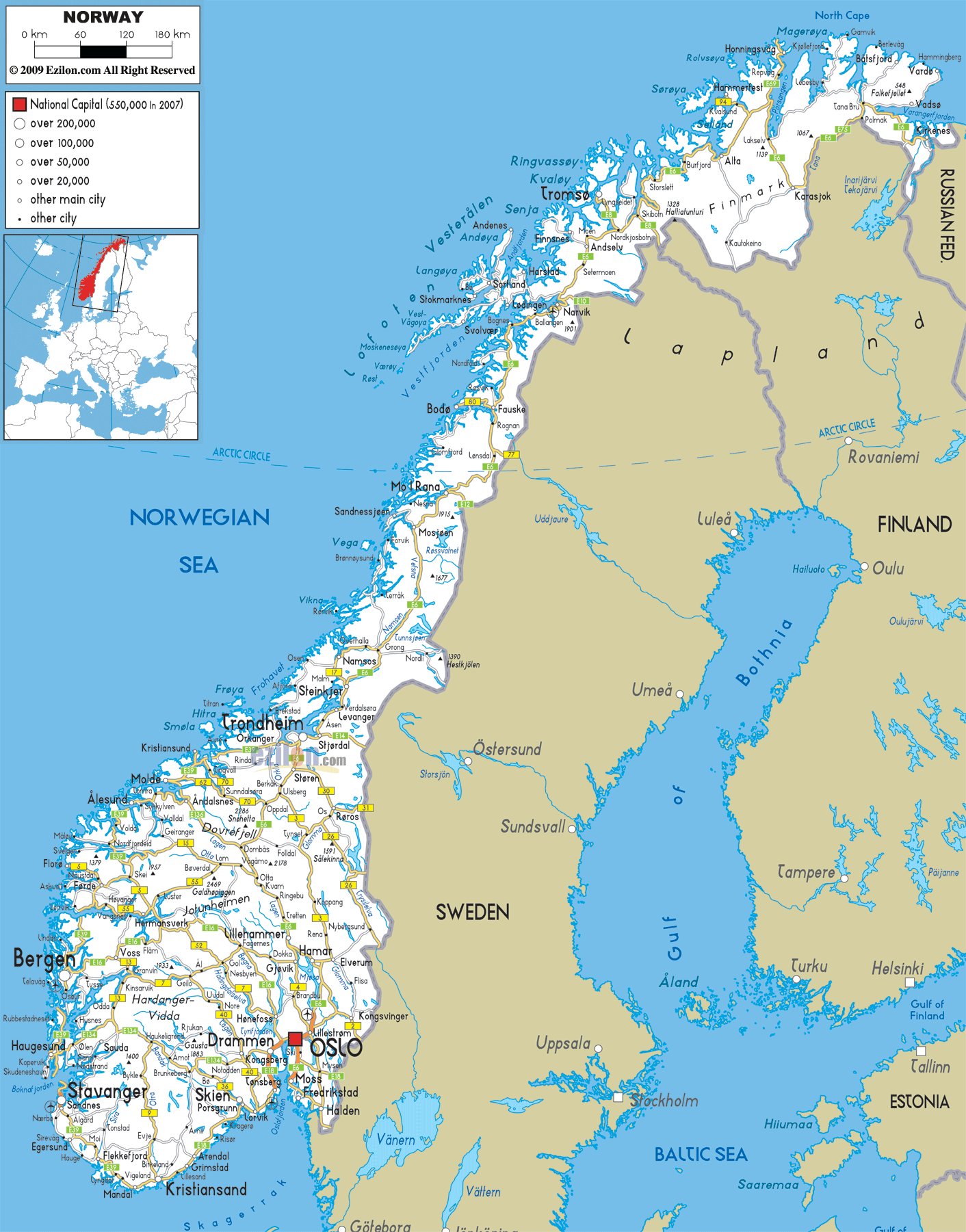
Description: Detailed clear large road map of Norway with road routes and driving directions from cities, counties to towns, road intersections / exit roads in regions, provinces, prefectures, also with routes leading to neighboring countries.
 Norway has very long motorways connecting several large cities, towns and villages. Road routes are divided into national, county, municipal and private routes. National and county roads are managed Norwegian Public Roads Administration. Car drivers are only allowed to drive on the right-hand side of the road and overtake on the left using their left-hand-drive vehicles.
Roads in Northern Norway E69, E75, E6 are notable roads seen in the northern part of the country connecting Hammerfest, Repvog, Hanningsvag, Kirkenes, Tana Bru, Palmak and Karasjak. E6 which started from Kirkens (near border town with Russia Federation) is the longest road in Norway almost passing all major cities in Norway. This road connects with Burfjord, Storslett, Skiboln, Nordkjosbotn to Moen, Andselv, Setermoen all the way to the city of Narvik. E8 links Tromsø in the western part of the country with Nordkjosbotn to the border via Skiboln exit with Lapland, Norway.
Roads in the Central Norway E6 has an intersection with Bodø at Fauske, continued to Rognan and Lensdal. E12 joins E6 at Mo i Rana a town in municipality of Rana in Nordland county. This motorway continues to Mosjøen, Grong, Steinkjer to Levanger were it joins with E14 at Stjordal which is not far from the city of Trondheim. E39 is the second longest road in the country which originates from Trondheim passes through western coast towns of Orkanger to Molde, Ålesund city in Møre og Romsdal county. This road continues down to city of Bergen in the south via Førde
Roads in the South E6, E18, E16 and E134 are notable road network that leads in and out of the capital city of Oslo in the South East part of the country. This road also leads to nearby towns such as Drammen, Moss, Fredrikstad and Halden near the border with Sweden. E39 passed through southern coastal towns of Haugesund, Stavanger, sandness, Algard, Moi, Flekkefjord to city of Kristiansand and also connecting Grimslad, Arendal and Skien .

Physical Map of Norway
Physical map and map image of Norway.

Political Map of Norway
Political map and map image of Norway.

Regional Directory of United States of America
Information and guide about United States of America and websites with American topics.

Regional Directory of Europe
Information and guide about Europe and websites with European topics.

Regional Directory of Australia
Information and guide about Australia and websites with Australian topics.