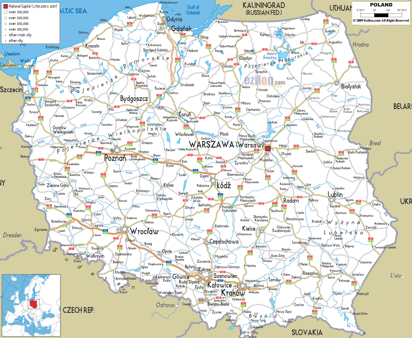
Description: Detailed clear large road map of Poland with road routes from cities to towns, road intersections / exit roads in regions, provinces, prefectures, also with routes leading to neighboring countries.
 Poland has roads that connect virtually to its towns, villages and cities, the roads are classified into National roads, Voivodeship roads, Powait roads and Gmina roads. Motorways are labeled A1, A2, A4, A6, A8 and A18 in the road map above and while Expressways are labeled S1, S2, S3, S5, S6, S7, S8, S10, S11, S12, S14, S17, S19, S22, S51, S61, S69, S74, S79 and S86 respectively. Road users drive on the right-hand side of the road and overtake other cars from the left hand side.
Northern Roads S7 is a major road and one of the longest in the country, the expressway started from Baltic coastal town of Gdansk passing towns of Elblag, Ostróda, Mlawa and up to the capital city of Warsaw in the central part. This road continued to Radom, Kielce and Kraków to Rabka near the border with Slovakia. S6 E28 Expressway connects Gdansk with Sopal, Gdynia, Rumia, Koszalin (intersection with S25) and continues to Nowogard, Goleniow and to the city of Szczecin in the north western part of the country near border with Germany.
Central Poland Roads Warszawa (Warsaw) are connected well with roads such as S2 E30 to Minsk, Siedlce, Miedzyrzec Podlaski city, Biala Podlaska near Belarus border with Belarus. S2 E30 also link Warsaw to the western cities notably with Kowicz, Kulno to city of Poznan in west-central Poland, to Swiebodzin and extending to the western border town of Slubice with Poland. S7 E77 connects Warsaw with southern cities start Grójec, to Radom intersecting with S12, S7 E77 continues at Szydlowiec to Kielce and all the way to southern city of Kraków (Krakow) near the border with Czech Republic .
Southern Roads
A4 E40 road passed through Wroclaw (Wroclaw), passing Opole to southern cities of Gliwice, Katowice and Krakow. S4 connects roads to south east of Kraków such as Wieliczka town, Brzesko, Tarnów, Debica, Rzeszów city, Przeworsk and to Jaroslaw and stopping in the border town of Przemysl near Ukraine in the south eastern part of the country.

Physical Map of Poland
Physical map and map image of Poland.

Political Map of Poland
Political map and map image of Poland.

Regional Directory of United States of America
Information and guide about United States of America and websites with American topics.

Regional Directory of Europe
Information and guide about Europe and websites with European topics.

Regional Directory of Australia
Information and guide about Australia and websites with Australian topics.