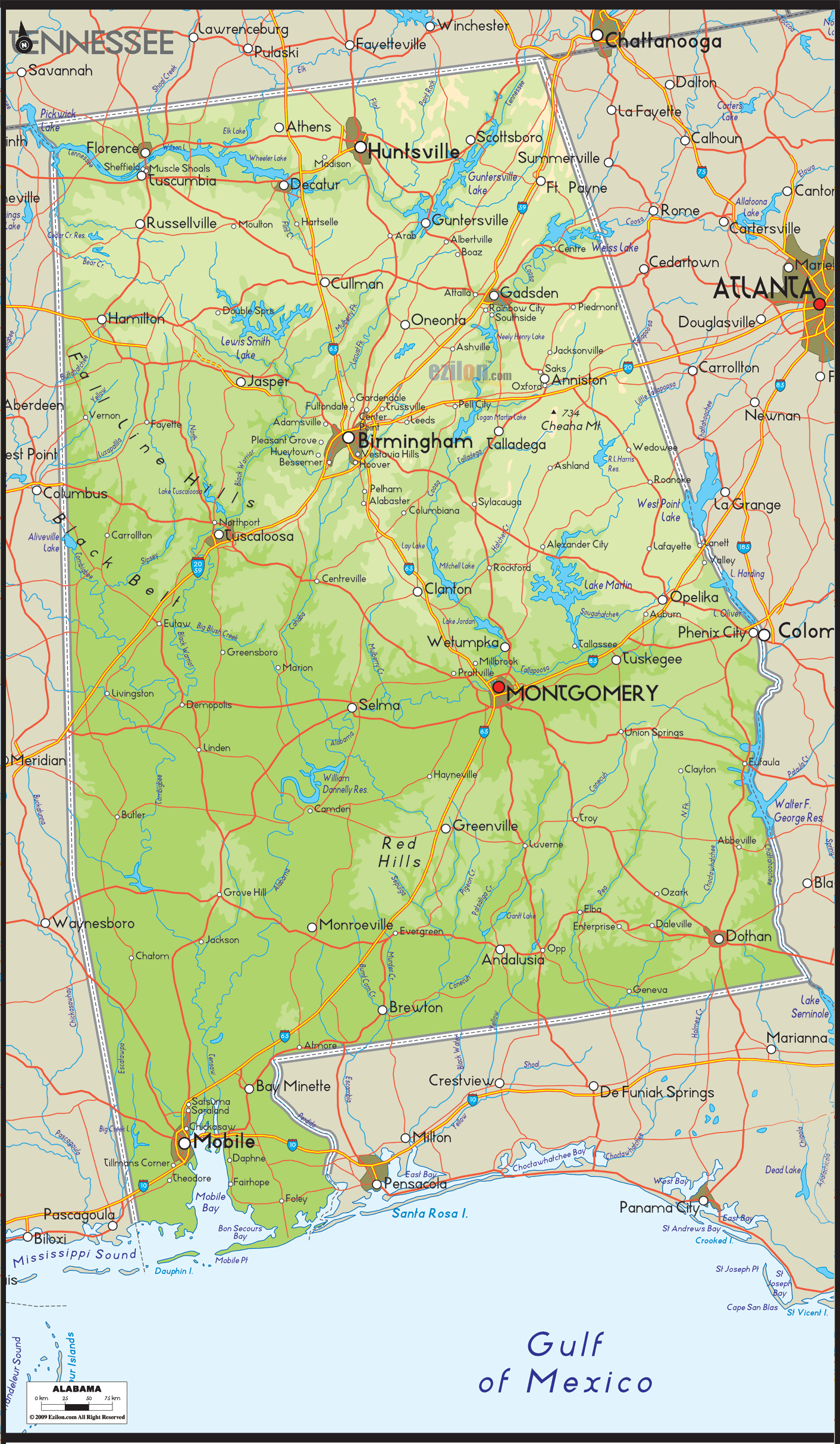

Description: Physical map of Alabama showing major geographical features such as rivers, lakes, mountains, hills, topography and land formations.

When you first set your eyes on a large, detailed physical map of Alabama, you're not just viewing a cartographic document but exploring a multifaceted and beautifully layered natural story. Just as each brushstroke adds texture and depth to a painting, every contour, hue, and symbol on this map contributes to a vivid narrative of Alabama's geographical richness.
This map stretches across the page as Alabama stretches across the Southern United States, revealing a diverse landscape of water bodies, landforms, and complex natural phenomena. Let's dig deeper into the intricate geography of Alabama, partitioning our exploration into five cardinal directions: the South, North, East, West, and Central Alabama.
As your gaze drifts towards the map's southern portion, the waterways' blue tendrils catch your attention. Mobile Bay is a dominant feature, a crescent moon-shaped water body with open arms stretching towards the Gulf of Mexico. Not just a geographic marvel, Mobile Bay serves as an ecological nursery and an economic powerhouse, delineated on the map in varying shades of blue.
People can conveniently reach the ocean from this region and engage in enjoyable pursuits. The I-10 bridge serves as a link to picturesque destinations such as Daphne and Spanish Fort. The famous Gulf Coast beaches are more than just a name on a map. The lighter colors represent the smooth transition between Alabama's land and the Gulf waters.
Further inland, rivers like the Tensaw and Alabama meander through the landscape like veins through a leaf. These rivers are often indicated with darker, more curved lines to show their depth and significance. Nearby, the map will often feature subtle bumps and lines indicative of the Coastal Plain's gentle hills as you move northward, signaling the landscape's slow transformation into a more varied topography.
In the northern area, you will notice lines showing how the land goes up and down. These are the foothills of the Appalachian Mountains, and they make their dramatic ascent here. One must catch the icon or altitude numbers representing Cheaha Mountain, Alabama's highest point at 2,407 feet. This towering mountain is often marked with a unique symbol or a distinct elevation figure, offering viewers a focal point of the region. Around here, you'll notice essential water bodies like Wheeler Lake, Guntersville Lake, Wilson Lake, and Lewis Smith Lake, each highlighted in distinct blue hues, serving as recreational and ecological havens.
Major roads like I-65 and U.S. Route 72 are presented in bold lines, connecting economic and cultural powerhouses like Huntsville and Decatur. Huntsville, a city that's a harmonious blend of topographical beauty and human ingenuity, sits near the Tennessee River. This significant waterway could be delineated in a rich blue hue or annotated with ripple symbols to emphasize its flowing grandeur and economic importance.
The landscape is an exciting mix of hills and plains in the eastern part of Alabama. Here, the Chattahoochee River sets a natural boundary with Georgia, often presented in dark shades of blue or annotated with flowing line symbols. Weiss Lake and Neely Henry Lake are significant bodies of water, indicated with unique shades or marks to point out their recreational and economic roles. The Fall Line Hills, an important geological boundary, could be represented by parallel lines or shading, denoting the transition from the Appalachian Highlands to the flatter Coastal Plain.
Gazing towards the west, you can spot the Tombigbee River, a water expanse worth exploring. The river's enormous magnitude and critical role have led to its clear depiction on the map, highlighted in bold blue. The Black Warrior River is joining the Tombigbee in its journey, forming a vital waterway network. Lakes like Logan Martin Lake and Mitchell Lake are other key features, each designated with symbols or color codes to indicate their importance in ecological and recreational terms. Route 43 and U. Sroute 82 share the same level of careful planning and meticulous design as the primary roadways in this local area.
When it comes to Central Alabama, it's like looking at a geographical crossroads. This region is where the flatlands of the Coastal Plain gradually rise to meet the Piedmont Plateau. The Alabama River takes center stage here, acting as a significant waterway that intersects the state. Montgomery, the state capital, would likely be marked with a star or a unique emblem, underlining its role as Alabama's political and cultural epicenter. Lakes like Lake Martin and Lake Jordan make their mark here, often indicated by distinct blue patches surrounded by an intricate network of roads, like I-65 and I-85, providing a comprehensive guide to navigating this part of the state.
To wrap it up, a large, detailed physical map of Alabama is more than a geographical representation; it's a richly illustrated narrative that speaks volumes about the state's diverse topography. This map paints a comprehensive picture from the Coastal Plains in the south to the Appalachian foothills in the north, from the historically rich landscapes in the east to the versatile terrains in the west, and into the bustling, vibrant heart of central Alabama.
With key lakes like Wheeler, Guntersville, Wilson, and Lewis Smith Lake prominently featured, along with essential hills like the Fall Line Hills and Red Hills, this map provides an unparalleled depth of information. Whether you're an enthusiastic traveler, a geography student, or a curious observer, this map is an indispensable tool for understanding Alabama—the Heart of Dixie—in all its geographical glory.

Political Map of Alabama
Political map and map image of Alabama.

Road Map of Alabama
Road map and map image of Alabama.

Regional Directory of United States of America
Information and guide about United States of America and websites with American topics.

Regional Directory of Europe
Information and guide about Europe and websites with European topics.

Regional Directory of Australia
Information and guide about Australia and websites with Australian topics.