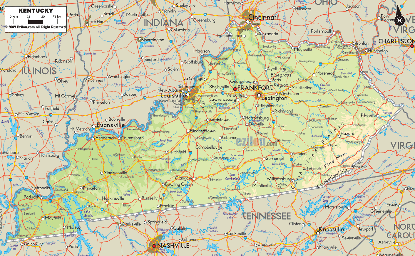

Description: The Physical map of Kentucky State, USA showing major geographical features such as rivers, lakes, topography and land formations.
 Introduction
Welcome to an extensive, meticulously crafted guide that dives deep into our Large, Detailed Physical Map of Kentucky. The map's ingenious design serves the purpose of aiding multiple groups of individuals, encompassing students, teachers, tourists, researchers, and decision-makers. It's not just a graphical representation of Kentucky's physical terrain; it's a storytelling medium that unravels the state's geographical richness in an insightful, multi-layered manner.
As you explore this guide, you'll understand Kentucky's regional diversities comprehensively, from the rugged terrain in the south to the fertile plains in the north and from the majestic Appalachian Mountains in the east to the mighty Mississippi River in the west.
The map is also incredibly detailed when it comes to central Kentucky, which is a melting pot of various geographical features. Boundaries with other states like Tennessee, Indiana, Ohio, and Missouri are delineated on the map, providing viewers with a geopolitical context that complements the physical geography.
In the southern region of Kentucky, one can immediately observe the dominance of the Cumberland Plateau. This area is essential geographically and holds historical and cultural significance.
For those interested in the nuances of topographical elevations, the map uses varying shades of color to differentiate elevations, augmented by contour lines that offer an almost three-dimensional understanding of the terrain. One must recognize the Cumberland Gap, a historical Appalachian mountain pass here.
It is where states like Kentucky, Tennessee, and Virginia meet, clearly marked on the map as a significant landmark. Furthermore, visitors can admire the huge Lake Cumberland and the meandering course of the Cumberland River. Their tributaries are intricately laid out, perfect for adventurers interested in kayaking or fishing in lesser-known waters. In addition, the map includes smaller watercourses such as Buck Creek and Fishing Creek. The map exhibits a great deal of intricacy.
As you traverse the map to the northern region of Kentucky, the Ohio River bursts into view. This mighty waterway is not just a natural border between Kentucky and neighboring states like Ohio and Indiana but also a lifeline fostering commerce and communities.
Detailed tributaries of the Ohio River, such as the Licking and Kentucky Rivers, are etched into the map, offering a convoluted network of waterways that intricately interact with the landscape. It is where the Bluegrass region comes into the picture, named due to the bluish buds that the grass produces in the spring.
The fertile loam of this region supports a verdant landscape, which is evident through the map's use of lush green colors. Here, smaller cities like Newport and Covington, located along the Ohio River, are marked, adding to the comprehensive nature of the map.
Eastern Kentucky is a testament to the state's rugged beauty and rich natural resources. The Appalachian Mountains are the star of this section, with their range marked in progressively darker shades, indicating rising elevations. If you're looking for specific mountain ranges like Pine Mountain and Black Mountain, you'll find them distinctly outlined and labeled.
The intricate river systems in this region, including the Big Sandy and the Kentucky River, are highly detailed, complete with their smaller branches, such as the North and South Fork. It provides a roadmap for adventure-seekers and scientists interested in exploring the lesser-known tributaries but ecologically vital.
When you turn your eyes towards the west, the prominent Mississippi River comes into view, dividing the states of Kentucky and Missouri. In this region, you'll notice a shift in topography—signaled by lighter color gradients and fewer contour lines.
The Jackson Purchase is unique due to its wetlands and lowlands, adding another layer of diversity to Kentucky's physical geography. Lakes such as Kentucky Lake and Barkley Lake are notable additions, often hotspots for fishing and water sports. The minor rivers feeding these lakes, like the Tennessee and Cumberland Rivers, are also marked with accuracy.
Central Kentucky, aptly represented in the map, is a fascinating geographical feature nexus. This region contains elements from the north's Bluegrass plains and the south's rugged Cumberland Plateau.
Adding further intrigue are the 'knobs,' a series of small, isolated hills spread across the landscape. The Kentucky River plays a significant role here; it provides crucial water resources and a kind of geographical spine supporting the state's central region. Various other rivers and streams, such as Elkhorn Creek and Salt River, are precisely marked.
By the time you've delved deep into this map and accompanying guide, you'll have embarked on a comprehensive geographical journey through Kentucky. Our Large Detailed Physical Map of Kentucky is more than just a visual guide; it's a narrative, a well-researched document, and a portal through which you can virtually traverse and understand this magnificent state.
The depiction captures an astonishing level of detail, showcasing everything from the coal-rich areas in the east to the bountiful agricultural lands in the north, from the majestic Appalachians to the meandering rivers interlacing the state. It's a perfect blend of scientific precision and artistic representation. Whether you are a student, a teacher, an explorer, or simply someone interested in understanding Kentucky's rich geographical tapestry, this map is an indispensable resource.

Counties and Road Map of Kentucky
Counties and Road map and map image of Kentucky.

Regional Directory of Canada
Information and guide about Canada and website listing.

Regional Directory of United States of America
Information and guide about United States of America and websites with American topics.

Regional Directory of Europe
Information and guide about Europe and websites with European topics.

Regional Directory of Australia
Information and guide about Australia and websites with Australian topics.