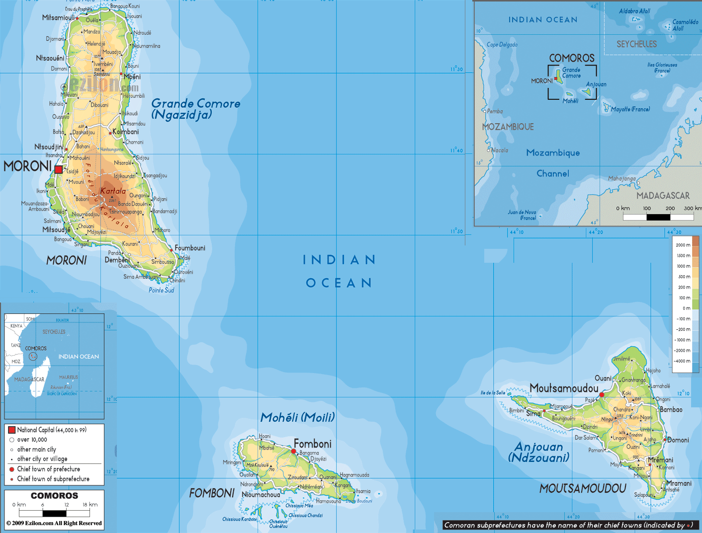
Description: The Physical Map of Comoros showing major geographical features like elevations, mountain ranges, deserts, Ocean, lakes, plateaus, peninsulas, rivers, plains, landforms and other topographic features.
 The
Comoros Archipelago is a group of islands situated in
the Mozambique Channel. The archipelago consists of 4
main islands and they cover up 2236 square kilometres.
Mount Karthala is 2316 metres high and is an active
volcano located on one of the islands. The country falls
between south latitude 12 degrees and 10 minutes and
east longitude 44 degrees and 15 minutes. The largest
island of the group is also the youngest and has been
formed due to volcanic activity.
The
Comoros Archipelago is a group of islands situated in
the Mozambique Channel. The archipelago consists of 4
main islands and they cover up 2236 square kilometres.
Mount Karthala is 2316 metres high and is an active
volcano located on one of the islands. The country falls
between south latitude 12 degrees and 10 minutes and
east longitude 44 degrees and 15 minutes. The largest
island of the group is also the youngest and has been
formed due to volcanic activity.
The volcano to the north is known as La Grille which
sits at a height of 1000 meters and the volcano to the
south is known as Karthala. The mountains are connected
by a high and flat plateau. The islands does not possess
the capability to hold water so manmade reservoirs
areused to store water during monsoons.
The second island holds 3 small mountain ranges Jimilime,
Sima and Nioumakele. The three chains originate from the
centre of the islands from a mountain called the Mtingui.
The smallest island in the group also has a distinct
mountain range which reaches its apex at approximately
860 meters. The oldest island possesses the most amount
of arable land due to its rich soil.

Political Map of Comoros
Political map and map image of Comoros.

Road Map of Comoros
Road map and map image of Comoros.

Regional Directory of United States of America
Information and guide about United States of America and websites with American topics.

Regional Directory of Europe
Information and guide about Europe and websites with European topics.

Regional Directory of Australia
Information and guide about Australia and websites with Australian topics.