Ezilon Maps offers free Middle East maps and country maps for every nation in the region, including detailed political maps, physical maps and road maps with capitals, major cities and borders. Browse maps of Saudi Arabia, Iran, Iraq, Turkey, Israel and every other Middle Eastern country with terrain and highway networks.
The Middle East countries maps collection on this page is designed as a one-stop, modern atlas of the region, giving you fast access to high-quality maps for every country in the Middle East. Whether you are a student, teacher, researcher, traveler, or simply map-curious, this page links you directly to detailed political, physical, historical, and thematic maps for all Middle Eastern countries.
Our collection goes beyond a single static regional map. It lets you explore each country individually, compare neighboring borders, discover capitals and major cities, and understand the physical geography that shapes the Middle East's climate, population, and history.
On this page, you can quickly move from a regional Middle East map to deep country-level detail in only a few clicks.
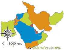
A map of the Middle East with labels for every country in the region.
Direct links to dedicated map pages for all countries, such as Saudi Arabia, Iran, Iraq, Israel, Egypt, Turkey, and others, are usually grouped under the Middle East.
Political maps indicate country boundaries, provinces, and the capital.
A physical map of the Middle East showing deserts, mountains, rivers, and coastlines.
Thematic maps for certain countries, including population, major cities, and, sometimes, historical or empire maps.
When available, downloadable or printable maps on the country pages make good classroom use or for reports.
Navigation is organized around the country name list found on this page. Each country name is clickable and takes you to its own map collection, so you can browse the whole region or focus on a single state.
This page is structured so you can move from general to specific in a logical path that mirrors how people actually research the Middle East.
Start with the regional Middle East map
At the top of the page, you see a clear, labeled map of Middle East countries, showing the relative position of states like Egypt, Saudi Arabia, Iran, Iraq, Israel, Jordan, Syria, Lebanon, Turkey, Yemen, Oman, Qatar, Bahrain, Kuwait, the United Arab Emirates, and others commonly included in the region.
This regional map helps you visualize where the Middle East sits between Europe, Africa, and Asia, and how key seas and gulfs (such as the Mediterranean, Red Sea, and Persian Gulf) frame the region.
Scroll to the country list below the map
Under the regional map, you find a list of Middle East countries with each country name presented in an easy‑to‑scan format.
Next to each country, you will see quick facts such as the capital city, approximate area, and population range, which provide context before you click into the detailed maps page.
Click a country name to open its dedicated map page
Each country name is linked to its own country map page, where you can find:
A detailed political map with internal administrative boundaries, provinces, or governorates.
A physical map showing mountains, deserts, rivers, and coastal plains.
A capital city map and often a city‑level inset focusing on major urban centers such as Cairo, Tehran, Baghdad, Riyadh, Ankara, Amman, Beirut, Jerusalem, Doha, Abu Dhabi, and others.
Selected thematic maps, such as population density, climate zones, or historical borders, depending on available data.
Downloading or printing our maps is not permitted.
For lesson plans, presentations, or personal reference, you can use linked interactive tools or images and labeled maps of the country or the entire region.
Many of these are suitable for classroom quizzes, coloring exercises, or memorization activities on Middle Eastern countries and their capitals.
Understanding Middle East maps is easier when you put the region in its broader geographic context. Though the Middle East refers to the regions of Arabia and Mesopotamia, it has generally come to include the countries of the Arabian Peninsula, the Levant, North Africa, Turkey, and Iran. The other states included Egypt, Saudi Arabia, Iran, Iraq, Israel, Jordan, Syria, Lebanon, Turkey, Yemen, Oman, Qatar, Bahrain, Kuwait, and the United Arab Emirates. Some definitions also extend to countries like Cyprus and other North African states, depending on the context.
The region covers millions of square kilometers and includes some of the world's most important deserts, mountain ranges, and waterways. When you use this page, you see how the Middle East political map interacts with key physical features such as the Arabian Desert, the Zagros Mountains, the Nile River, and the Tigris‑Euphrates system, which have shaped settlement patterns, agriculture, and trade routes for thousands of years.
Below is how the countries section is structured and how it is described on the page, so visitors immediately understand what they can explore when they click.
On this page, Egypt is presented as the Middle East's bridge to North Africa, with maps that highlight its position along the Nile River and the Mediterranean and Red Sea coasts. When you click "Egypt," you open detailed maps showing the capital, Cairo, major cities, the Suez Canal, and the surrounding desert regions.
Under " Saudi Arabia," visitors can access maps showing the kingdom's vast land area on the Arabian Peninsula, its borders with neighboring Gulf states, and key cities such as Riyadh, Jeddah, and Mecca. Political and physical maps help you see the vast desert interior, coastal plains, and mountain ranges along the Red Sea.
Iran's map collection emphasizes its size, diverse terrain, and strategic position between the Middle East and Central Asia. When users click "Iran, " they find maps of the capital, Tehran, provincial boundaries, major mountain ranges such as the Zagros and Alborz, and bodies of water, including the Caspian Sea and the Persian Gulf.
These maps show the Tigris and Euphrates rivers, the country's borders with Iran, Turkey, Syria, Jordan, Saudi Arabia, and Kuwait, and the most important cities, including Baghdad, Mosul, and Basra. Through visitors, one can observe the fertile river valleys and the barren landmasses.
When users click the "Israel" or "Palestine" tiles, they are taken to highly detailed political maps. These maps show, inter alia, the internationally recognized borders, major cities, and major geographic features of that region, including the Mediterranean Coast, the Jordan River, and the Dead Sea. These maps allow users to visualize one of the most controversial places in the Middle East, notably Jerusalem and other significant sites.
The Jordan maps focus on the capital Amman, key desert landscapes, and the country's position between Israel, Syria, Iraq, and Saudi Arabia. Visitors can study how Jordan's limited coastline on the Gulf of Aqaba connects it to the Red Sea.
Clicking "Lebanon" displays maps of the narrow coastal strip along the Mediterranean, the Lebanon Mountains, and the capital, Beirut. These maps highlight how Lebanon's terrain influences its climate and population distribution.
The Syria maps emphasize the capital Damascus, other major cities, and the country's position at a crossroads between Turkey, Iraq, Jordan, Lebanon, and the Mediterranean Sea. Physical maps show its diverse landscapes, including fertile plains and arid interior areas.
Under "Turkey," visitors find maps that connect the Middle East to Europe and the Caucasus, with Ankara as the capital and Istanbul straddling the Bosporus. Both political and physical maps show Turkey's extensive coastline, mountain ranges, and plateau regions.
Each Gulf state has its own linked map page.
Maps of the United Arab Emirates show major Emirate regions, such as Abu Dhabi and Dubai, along the Gulf coast.
Doha and the peninsula's small geographical area are shown on Qatar maps.
Maps of Bahrain focus on the island kingdom's urban areas and large causeways.
The maps of Kuwait present Kuwait City and the bay. Also marks its land borders with Iraq and Saudi Arabia.
Maps of Oman show where the country's capital and long coastline are located.
The Yemen section includes maps showing the country's location in the southern Arabian Peninsula, its capital, Sanaa, and its coastline along the Red Sea and the Gulf of Aden. Physical maps highlight highland areas and coastal plains that are important for understanding climate and settlement.
This Middle East map collection is not only a gallery; it is also a practical learning and research tool.
For students and teachers:
Use labeled and blank Middle East political maps and Middle East physical maps in geography or history lessons, quiz games, and memorization exercises about countries and capitals.
Classrooms can combine printable maps with map quizzes, asking students to locate countries such as Egypt, Iran, Iraq, Saudi Arabia, Turkey, Yemen, and others on an unlabeled Middle East outline map.
For travelers and researchers:
Tourists will be able to see the locations of important countries in the region, such as Cairo, Tehran, Istanbul, Riyadh, Amman, Beirut, Dubai, Doha, and Muscat.
The interpretation of energy networks, trade routes, and geopolitical nuances by researchers and analysts can draw on geographic context, spanning physical and political geographies.
For history and culture enthusiasts:
By linking to historical and thematic maps when available, such as those of ancient kingdoms, empires, and older political borders, this page provides an accessible entry point into the long history of the Middle East.
Exploring the same locations across different periods shows how modern Middle East borders relate to older cultural and political regions.
Web Directory |
 |
| Ezilon Middle East: List of websites with Middle Eastern topics, includes arts, business, education, travel and other Middle Eastern information. |