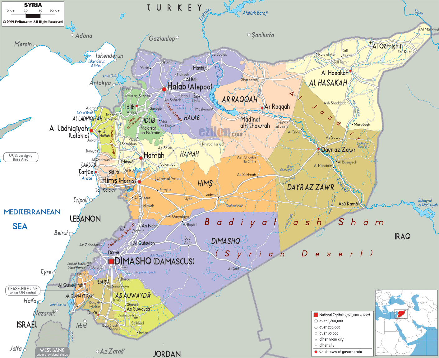
Description: Detailed large political map of Syria showing names of capital city, towns, states, provinces and boundaries with neighbouring countries.

When you look closely at the Map of Syria with cities, you immediately notice how the country sits at a strategic crossroads of the Middle East, making it one of the most geographically significant locations in the region. This Syria map, with major cities and a road network, clearly shows how the country connects Asia, Europe, and Africa through its borders and regional pathways.
Syria's northern neighbor is Turkey; to the east is Iraq; to the south is Jordan; to the southwest are Israel and Lebanon; and to the west is the Mediterranean Sea. These borders are clearly outlined on the map, helping readers and users visualize Syria's role as a land bridge between regions.
The detailed map of Syria also highlights the country's stretch from fertile coastal plains near the Mediterranean Sea to vast desert landscapes in the east. This contrast is important because it explains settlement patterns, economic activities, and historical trade routes that developed over centuries.
As you follow the map visually, the road-light network gives you orientation without overwhelming the layout. Major routes connect cities like Damascus, Aleppo, and Homs, making it easier to understand how movement happens across the country.
In the southwestern part of the Syria map, you will find Damascus, prominently marked as the capital. This city is one of the most important features on the map, both geographically and historically.
Damascus sits near the border with Lebanon and not far from Israel and Jordan, making it a central point for regional connectivity. On the best map of Syria, you can see how roads extend outward from Damascus: southward into Daraa, northward toward Homs, and westward toward the coastal regions.
The location of Damascus is significant because it lies on fertile land, unlike the surrounding semi-arid regions. This explains why it has been continuously inhabited for thousands of years.
As you trace the map, you can clearly see how Damascus acts as a hub linking southern Syria with central and western regions, making it one of the most important nodes in the country's road network.
Moving your eyes northward on the detailed Syria map, you will encounter Aleppo, one of the largest and most historically significant cities in Syria.
As depicted on the map, Aleppo is situated very close to the Turkish border. Because of the proximity, it serves as a passway between Syria and Turkey. The map of Syria with cities shows that Aleppo is connected to Idlib, Raqqa, and Hama by several major routes, making it an important hub.
The surrounding region of Aleppo appears more fertile compared to eastern desert areas, which explains why agriculture has been prominent here. Historically, Aleppo was a major stop along trade routes linking the Mediterranean to inland Asia.
On the map, Aleppo's location helps users understand Syria's northern geography and how the region interacts with neighboring countries.
At the heart of the Syria map with major cities, you will find Homs and Hama, two cities that form the backbone of central Syria.
Homs is located slightly south of Hama and appears as a major junction on the map. Roads from Damascus, Aleppo, and the coastal regions all converge here. This makes Homs one of the most strategically positioned cities in Syria.
The road-light network shows Homs acting as a connector between east and west, linking desert regions to the Mediterranean coast.
Just north of Homs, Hama is clearly labeled on the map. It sits along the Orontes River, which is one of the few significant rivers in western Syria.
Hama's placement helps users understand how central Syria transitions from more densely populated western areas to less densely populated eastern landscapes.
Together, Homs and Hama form a central corridor critical to movement, trade, and communication across Syria.
On the western edge of the map of Syria, you will notice the coastline along the Mediterranean Sea, where the cities of Latakia and Tartus are located.
Latakia is a coastal city in northern Syria and Syria's main port. On the best map of Syria, you can see how it connects inland regions to the sea, making it vital for trade and transportation.
Tartus is located south of Latakia, another important port city. The map indicates Tartus as a slightly smaller port, but it still has maritime access.
The coastal area has more greenery than the interior region due to higher rainfall and better agricultural conditions.
These coastal cities are essential for understanding Syria's access to international waters and its economic connections beyond land borders.
On the Syria map with cities, Idlib is clearly marked. This area sits near the Turkish border and is surrounded by agricultural land.
The map shows Idlib connected to Aleppo and Latakia, forming a triangle of important northern and western cities. This region is more densely populated compared to the eastern parts of Syria.
As you follow the map visually, you can see how the terrain transitions from coastal mountains to inland plains, making this area important for farming and settlement.
Moving toward the central-northern part of the detailed Syria map, you will find Raqqa, located along the Euphrates River.
The Euphrates is one of the most important geographic features on the map, running from north to southeast. Raqqa's position along this river highlights its importance as a water-based settlement in an otherwise dry region.
The map of Syria with major cities shows Raqqa, connected to Aleppo to the west and Deir ez-Zor to the east, forming a key corridor along the river.
Further east, the map highlights Deir ez-Zor, another major city along the Euphrates River.
This region appears more arid, with large desert areas surrounding the river valley. The contrast between the fertile riverbanks and the surrounding Desert is clearly visible on the map.
Deir ez-Zor's location near the Iraqi border emphasizes its role as a link between Syria and Iraq.
In the northeastern corner of the Syria map, you will see Al Hasakah, located near both Turkey and Iraq.
This region is part of Syria's agricultural zone, benefiting from rivers and relatively higher rainfall than the desert interior.
The map shows Al Hasakah connected to Qamishli and other northern towns, forming an important cluster of settlements near the international borders.
Looking at the southern section of the map of Syria, you will find Daraa and As-Suwayda, two important regions near Jordan.
The city of Daraa is near the Jordanian frontier and is linked to Damascus by highways: more southerly, and key, a gateway into Syria.
The map shows that As-Suwayda, farther east, is more mountainous. The geography of this region is different from the more level terrain surrounding Daraa.
Together, these southern regions help define Syria's connection to Jordan and the broader Arabian Peninsula.
One of the most striking features on the detailed map of Syria is the vast Syrian Desert, which covers much of the country's central and eastern regions.
This desert region is labeled clearly and shows minimal urban development compared to the western regions. The map highlights how settlements are concentrated along rivers and major roads rather than spread evenly across the Desert.
The presence of the Desert explains why cities like Damascus, Homs, and Aleppo developed where they did, as these areas have better access to water and resources.
The Euphrates River is one of the most important features on the Syria map. It flows from Turkey into Syria and continues southeast into Iraq.
Cities like Raqqa and Deir ez-Zor are located along this river, demonstrating its importance for agriculture and human settlement.
On the map, the river acts as a natural guide, helping users understand how life in eastern Syria depends heavily on water availability.
The Syria map with neighboring countries provides a clear view of how Syria interacts with surrounding regions.
Turkey (North): Strong connections through Aleppo and Idlib
Iraq (East): Linked via Deir ez-Zor and desert routes
Jordan (South): Access through Daraa
Lebanon (West): Close to Damascus and coastal regions
Israel (Southwest): Near the Golan Heights
Mediterranean Sea (West): Coastal access via Latakia and Tartus
These borders are essential for understanding Syria's geopolitical and economic position.
While the map does not show every road in detail, the road-light network conveys adequately how the major cities are connected.
Key routes include:
Damascus to Homs and Aleppo
Aleppo to Raqqa and the eastern regions
Coastal cities to inland urban centers
Southern routes linking Daraa to Damascus
These routes form the backbone of transportation across the country.
This is the best map of Syria, which is valuable for multiple audiences:
It helps visualize geography, cities, and regions clearly.
It provides a sense of distance, layout, and connectivity.
It offers insights into terrain, borders, and regional relationships.
By following a map of Syria with cities and regions, you gain a complete understanding of the country's structure.
From the Mediterranean coast to the deserts of the east, from Damascus in the south to Aleppo in the north, every part of Syria contributes to shaping its geography and identity.
This detailed, human-readable map allows you to explore Syria visually, making it easier to understand its cities, regions, and connections at a glance.
Syria is positioned in the Middle East between Turkey, Iraq, Jordan, Israel, Lebanon, and the Mediterranean Sea.
Damascus is the capital and appears in the southwestern region of the map.
Damascus, Aleppo, Homs, Hama, Latakia, Tartus, Raqqa, Deir ez-Zor, Idlib, and Daraa.
Aleppo is in northern Syria near Turkey.
Homs is centrally located linking major regions.
Hama is north of Homs along the Orontes River.
Latakia lies on the Mediterranean coast.
Tartus is south of Latakia along the coast.
Idlib is in northwestern Syria near Turkey.
Raqqa lies along the Euphrates River.
Deir ez-Zor is in eastern Syria near Iraq.
Al Hasakah is in northeastern Syria.
Daraa is located in southern Syria near Jordan.
As-Suwayda lies in southern mountainous Syria.
The Euphrates River runs across the country.
Yes, the Syrian Desert covers central and eastern regions.
The Mediterranean Sea borders Syria to the west.
Turkey, Iraq, Jordan, Israel, and Lebanon.
Yes, key roads connect major cities.
Yes, it connects to major cities and regions.
A large dry region dominating eastern Syria.
Aleppo is a historic trade and cultural hub.
It provides access to sea trade routes.
Homs connects all major regions of Syria.
Desert terrain and the Euphrates River valley.
Yes, it supports geography learning.
Yes, it shows distances and city layout.
Yes, administrative regions are clearly marked.
Yes, all major cities are labeled.
No. Printing or copying is not allowed.

Physical Map of Syria
Physical map and map image of Syria.

Road Map of Syria
Road map and map image of Syria.

Regional Directory of United States of America
Information and guide about United States of America and websites with American topics.

Regional Directory of Europe
Information and guide about Europe and websites with European topics.

Regional Directory of Australia
Information and guide about Australia and websites with Australian topics.