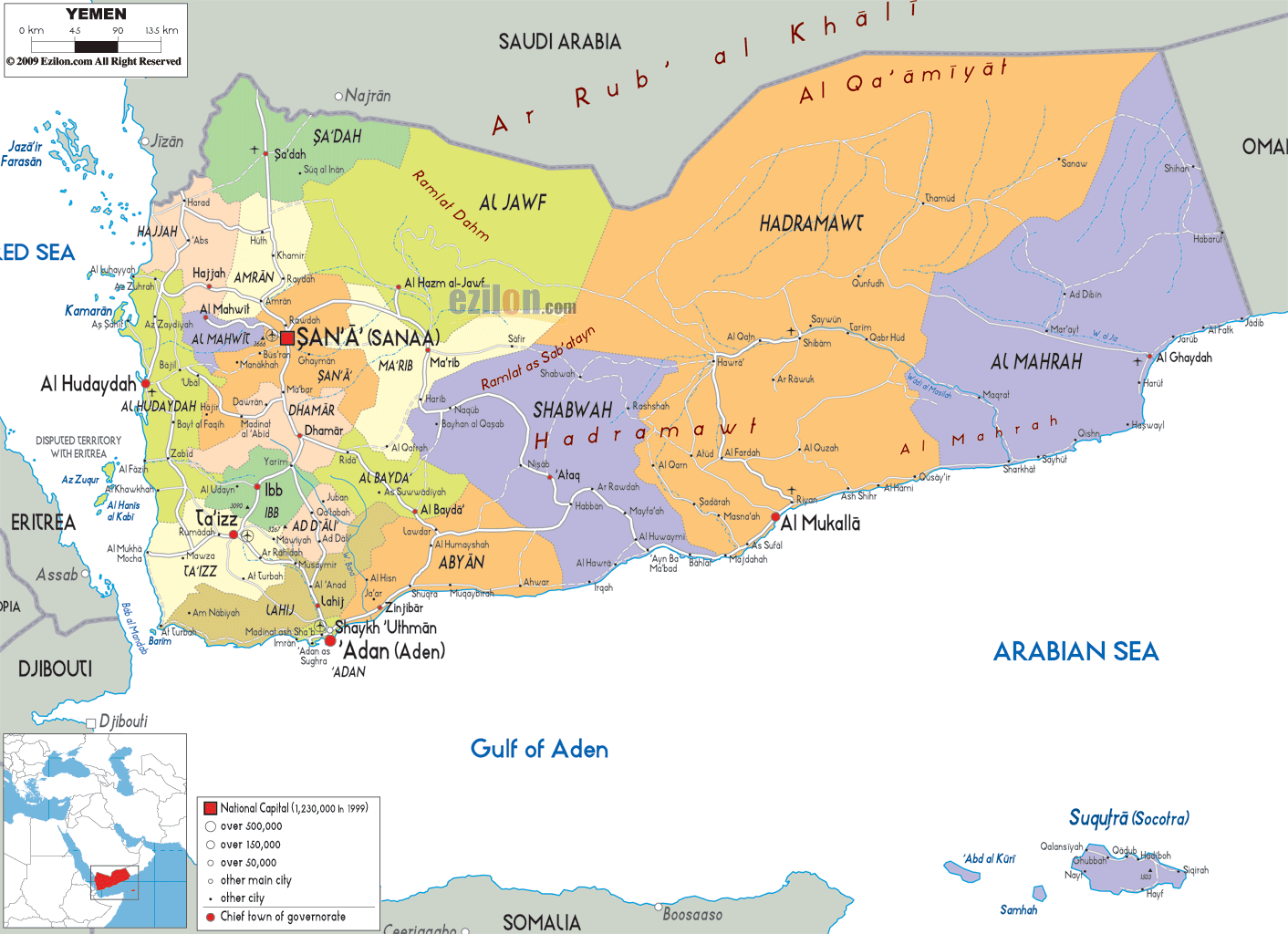
Description: Detailed map of Yemen with cities, towns, governorates, villages and surrounding countries. It shares borders with Saudi Arabia and Oman.
This map of Yemen with cities, governorates, and towns is already large enough to read directly on your desktop. To see a full-screen zoom view on a phone or tablet, tap the map image (or tap the Zoom Map label above the image). Scan by shading governorates in various colored blocks, with Yemen's cities and towns in bold.

The map of Yemen, with cities, major towns, and governorates, shows a country that extends like a long rectangle along the southern end of the Arabian Peninsula, bordered in the west by the Red Sea and in the east by the desert frontier with Oman. When you read Yemen's map, you are struck by the complexity of its layered structure: coastal plains, steep highlands, inland plateaus, and far-flung islands, each with its own cities and regional centres. This guide has been written to help you read the map as if someone were standing by your side, showing you the location of each place and how all the regions are connected.
Further west on a regional inset, the map shows Yemen occupying the southern tip of the Arabian Peninsula, directly facing the Horn of Africa across the Gulf of Aden and the Arabian Sea. To the north, you will see the long boundary with Saudi Arabia curving over the highlands and desert, while to the east, the frontier with Oman closes the rectangle of the country's outline. The coastline touches the Red Sea on the south and west and the Arabian Sea on the southeast. Therefore, it is clear why Yemen occupies a strategic location that controls the Bab al-Mandeb Strait and sea lanes to the Suez Canal.
If you scan from left to right across the interior of the map, four broad physical zones become visible:
Western coastal plain (Tihamah) – a hot, low‑lying strip along the Red Sea, where ports and fishing towns lie close to the shoreline.
Central and western highlands – a band of rugged mountains and uplands running roughly north–south, where many of the largest high‑density cities are located.
Eastern plateaus and deserts – a drier region of plateaus and desert basins stretching through Ma'rib, Al Jawf, Hadramawt, and Al Mahrah.
Offshore islands – the Socotra Archipelago in the Arabian Sea, shown separately to the southeast of the mainland.
This physical framework explains the pattern of governorates and the distribution of cities you see labeled across the country.
The map shows Yemen divided into clearly colored governorates, each outlined and labeled with its name and chief town. If you look near the center‑west of the map, you will see Sana'a, the national capital, highlighted as its own municipal unit surrounded by Sana'a Governorate. Around it, the names of other governorates radiate outward in all directions:
To the northwest, Sa'dah and Hajjah.
To the west and southwest are Al Mahwit, Raymah, and Ta'izz.
To the south, Dhamar, Ibb, and further down toward Lahij and Aden.
To the northeast and east are 'Amran, Al Jawf, Ma'rib, and Al Bayda.
By following these labels, you can read the country province by province and see how each governorate aligns with distinct landscapes.
The map uses larger symbols and bold type to mark the main cities and ports. As you move your attention from one symbol to another, a core urban network comes into focus:
Sana'a is in the highlands near the center‑west.
Ta'izz, Ibb, and Dhamar form a dense chain in the southern highlands.
Aden on the Gulf of Aden coast in the south.
Al Hudaydah is on the Red Sea coast to the west.
Al Mukalla and Seiyun in Hadramawt to the east.
Sa'dah, Al Hazm, and Ma'rib are close to the northern and northeastern margins of the desert.
These cities serve as anchors that help you orient the surrounding towns and roads when reading the map.
As you shift your attention to the western side of the map, you will notice a long, narrow coastal strip along the Red Sea labeled as part of Al Hudaydah and Hajjah governorates. Al Hudaydah city is shown roughly halfway down this coast, right on the shoreline, clearly marked as a major seaport. From Al Hudaydah, the map shows roads running inland and uphill toward Sana'a, Ibb, and Ta'izz, illustrating how this low coastal city is tied to the richer highlands just to the east.
If you look further north along the coast, the names of smaller towns appear within Hajjah Governorate, backed quickly by hills and mountains. The proximity of the sea and the rising ground account for the Tihamah plain appearing as a narrow strip on the map, with settlements crammed between water and slopes.
Moving slightly inland from the coast, the map clearly marks Hajjah, the capital of Hajjah Governorate, in a mountainous area northwest of Sana'a. Roads from Hajjah bend south and southeast toward 'Amran and Sana'a, and westward back down to Al Hudaydah, showing how this city connects the interior highlands to the Red Sea ports. If you trace the northern upper part of the map, Sa'dah appears above Hajjah in rugged terrain near the Saudi border, forming part of the northwestern highland corridor.
If you go south from Sana'a along the main highland axis, the map leads you through Dhamar and into a tight cluster of governorates named Ibb and Ta'izz. Ta'izz is located just inland from the Gulf of Aden, but still in the mountains, with roads reaching west to coastal towns and east toward Ibb and into more interior regions. Ibb lies north of Ta'izz, is labeled the capital of Ibb Governorate, and is ringed by numerous smaller settlements, signaling a heavily populated, agriculturally rich area.
The map shows how roads from Ta'izz and Ibb descend westward toward the Red Sea and southward and southeastward toward Aden and Abyan. This configuration makes the southern highlands a key crossroads between the western and southern coasts.
Further northwest of Sana'a is Al Mahwit Governorate, with its capital, Al Mahwit, located in rugged uplands between the high capital plateau and the coastal plain. Further south, Raymah Governorate, with its chief town Al Jabin, is again tied to both the highland and coastal roads. The map shows how these two governorates serve as "stepping stones" between Sana'a and Al Hudaydah, with winding routes that drop from the highlands to the Tihamah plain.
At the center‑west of the country, the map highlights Sana'a with a distinctive symbol, underscoring its status as the capital and a major metropolis. Roads reach out from Sana'a in all directions:
North toward 'Amran and Sa'dah.
South toward Dhamar, then further to Ibb and Ta'izz.
West toward Al Mahwit and the port of Al Hudaydah.
East and northeast toward Ma'rib and Al Jawf.
The map indicates how these radiating routes make Sana'a the primary political and transport hub, linking hotels and towns, the highland village, the desert gateway, and the coastal port.
Just north of Sana'a, the map clearly marks 'Amran, the capital of 'Amran Governorate, located on the road toward Sa'dah and the northern highlands. To the south, Dhamar appears along the main trunk road that continues toward Ibb and Ta'izz, and its central position in the highlands is emphasized by the network of smaller roads that branch from it.
Further southeast from Dhamar, the map shows Al Bayda Governorate stretching into a mixed landscape of uplands and plateaus. Between the highland core and the more arid interior lies its capital, Al Bayda, with roads to Abyan, Shabwah, and Ma'rib. The map indicates that Al Bayda is a transitional governorate that connects the highlands to the east and south.
Looking at the northwest near the top of the map, you will find Sa'dah Governorate, pressed against the border with Saudi Arabia. The city of Sa'dah appears inland in mountainous terrain, connected by a main route running south toward 'Amran and Sana'a. The map shows how this highland corridor forms a continuous spine from the northern frontier down to the capital, with settlements following valleys and passes rather than open desert.
Looking at the north‑east on the far right side of the mainland, the map shows Al Jawf Governorate stretching along the desert margin. Al Hazm, the capital city, situated in a sparse landscape, is connected by vast roads to Sana'a in the west and to Ma'rib in the south.
Further south, the Ma'rib Governorate emerges as yet another desert-edge region with Ma'rib town located at the point of contact between the highland foothills and open sands. The map shows how routes from Ma'rib lead back toward Sana'a and Al Bayda, and outward toward the eastern plateaus, underlining Ma'rib's role as a gateway between the cultivated highlands and the arid interior.
Further east, the map shows the large and expansive Hadramawt Governorate occupying the center‑east of the country. Inland, the name Seiyun (or Say'un) appears in the middle of a long valley labeled Wadi Hadhramaut, where settlements line the wadi floor in a linear pattern. On the coast, the map clearly marks Al Mukalla as the capital city, sitting directly on the Arabian Sea and connected inland to Seiyun by a main road that climbs out of the wadi.
This arrangement illustrates how Hadramawt is divided between a deeply incised interior valley system and a coastal strip, both of which are tied together by the transport routes you can trace on the map.
You will see the Al Mahrah Governorate in the eastern corner of Yemen, toward the far southeastern area of the map. The capital of Al Ghaydah lies on the coast of the Arabian Sea, with long stretches of road running to the west towards Al Mukalla and east to the border with Oman. The map shows a very low density of towns in this area, emphasizing the desert character of the region and its function as a long, sparsely populated frontier.
If you go south from Sana'a and then follow the roads down through Dhamar, Ibb, and Lahij, the map eventually brings you to the prominent coastal city of Aden. Aden is located on a peninsula that juts into the Gulf of Aden, and it is clearly marked as a major port and the capital of Aden Governorate. The map shows multiple routes converging here from Ta'izz, Lahij, and Abyan, underscoring Aden's role as a southern maritime gateway through which highland trade reaches the sea.
Just to the north and northwest of Aden, Lahij Governorate lies, with its capital, Lahij, placed slightly inland along the route to Ta'izz. The roads between Lahij, Ta'izz, and Aden are shown as major connectors, indicating heavy movement of people and goods between these urban centers.
Further east along the Gulf of Aden, the map shows Abyan Governorate extending from the coastline inland toward the foothills. Its capital, Zinjibar, sits near the shore, while roads reach northwest toward Al Bayda and northeast toward Shabwah. This layout makes clear how Abyan functions as both a coastal and interior province, bridging seaborne and overland routes.
Further east along the map's inland side, the governorate of Shabwah spans a mixed landscape of hills and plateaus. Its capital, Ataq, lies away from the coast but is connected by roads that run westward from Abyan and eastward toward Hadramawt. The map shows how Shabwah serves as a passage between the southern coastal belt and the eastern valleys and deserts, forming an important inland link that complements the more maritime routes.
If you look very closely to the southeast, in the lower right corner of the map, you should see an inset or island outline labelled 'Socotra Archipelago'. Socratic is the main island of Hadibu, and the capital is marked on the map; smaller islands in the Arabian Sea may also be marked. Because Socotra lies far off the mainland, the map usually enlarges this archipelago in a box to make the place names legible and to show its relation to nearby sea routes.
The map shows shipping lanes and surrounding seas around Socotra, reminding the reader that these islands extend Yemen's reach deep into the Indian Ocean. Roads on the island itself are more limited than on the mainland. Still, the presence of Hadibu and coastal settlements demonstrates that the archipelago has its own local network of communities. When planning or studying Yemen as a whole, following the map out to Socotra helps you appreciate that the country is not only a land bridge on the Arabian Peninsula but also a maritime actor in the surrounding ocean spaces.
The map shows a hierarchy of roads - some drawn as thicker lines to represent main highways, others as thinner lines for secondary routes. If you trace these from north to south, you will see a dominant highland corridor running from Sa'dah through 'Amran, Sana'a, Dhamar, Ibb, and Ta'izz, then bending toward Lahij and Aden. Cross-routes heading west to Al Hudaydah and the Red Sea and east to Ma'rib, Al Jawf, and the Hadramawt valley radiated.
To read the transport network effectively:
Start at Sana'a and follow each major road outward to see which city it connects next.
Notice how coastal ports like Al Hudaydah, Aden, and Al Mukalla are always linked by at least one major inland route to the highlands or interior plateaus.
Observe how desert governorates such as Al Mahrah and Al Jawf feature longer, straighter road segments with fewer towns, indicating sparse settlement.
Although the map does not include detailed contours, it nevertheless suggests a relief pattern through place names and the shapes of governorates. The proximity of cities in the western and central uplands points to this heavy settlement pattern. The wide spaces between towns in the east and north‑east are an indication of the less arid areas. A clear difference is seen when comparing the west side and the east side:
Western highlands (Ta'izz, Ibb, Dhamar, Sana'a, 'Amran) show many towns and complex road webs.
Eastern plateaus and deserts (Ma'rib, Al Jawf, Hadramawt interior, Al Mahrah) show fewer towns and long connecting routes.
By keeping this pattern in mind, you can quickly judge which regions of Yemen are more densely inhabited just by looking at the map.
To read the map of Yemen like an expert and to remember where each city and region lies, you can follow a simple step‑by‑step approach:
Begin in the highland core.
Locate Sana'a near the center‑west.
From there, identify Dhamar, Ibb, and Ta'izz directly to the south along the main highland corridor.
Shift to the western coast.
Move your eyes west from Sana'a to find Al Hudaydah on the Red Sea.
Trace the coastal strip north into Hajjah and south toward the coastal extensions of Ta'izz.
Explore the southern seaboard.
Follow the coast from the Bab al‑Mandab area eastward to Aden.
Continue along the Gulf of Aden to Abyan and then further east to the coastal fringe of Shabwah and Hadramawt.
Read the eastern interior.
From Abyan or Al Bayda, move inland to find Ataq in Shabwah and Ma'rib to the north‑east.
From Ma'rib, shift further east to the valleys and coastal city of Al Mukalla, then onward to Al Ghaydah in Al Mahrah.
Finish with the northern and island regions.
Look back up to the north to locate Sa'dah and Al Hazm near the Saudi border.
Finally, move to the inset or lower‑right corner to find Socotra and Hadibu, completing your tour of the entire national territory.
Using this kind of detailed map of Yemen offers clear value for different readers:
Travelers can access handy information about cities along the way, how far a port is from the highlands, and which roads cross the mountains or the desert.
Some students and researchers might examine how governorate boundaries align with physical regions, such as Hadramawt, which follows a main wadi system, or Al Mahrah, which covers the eastern desert.
With their own towns superimposed, residents and planners can see instantly how their towns connect to larger cities, a port, and a neighboring governorate.

Physical Map of Yemen
Physical map and map image of Yemen.

Road Map of Yemen
Road map and map image of Yemen.

Regional Directory of United States of America
Information and guide about United States of America and websites with American topics.

Regional Directory of Europe
Information and guide about Europe and websites with European topics.

Regional Directory of Australia
Information and guide about Australia and websites with Australian topics.