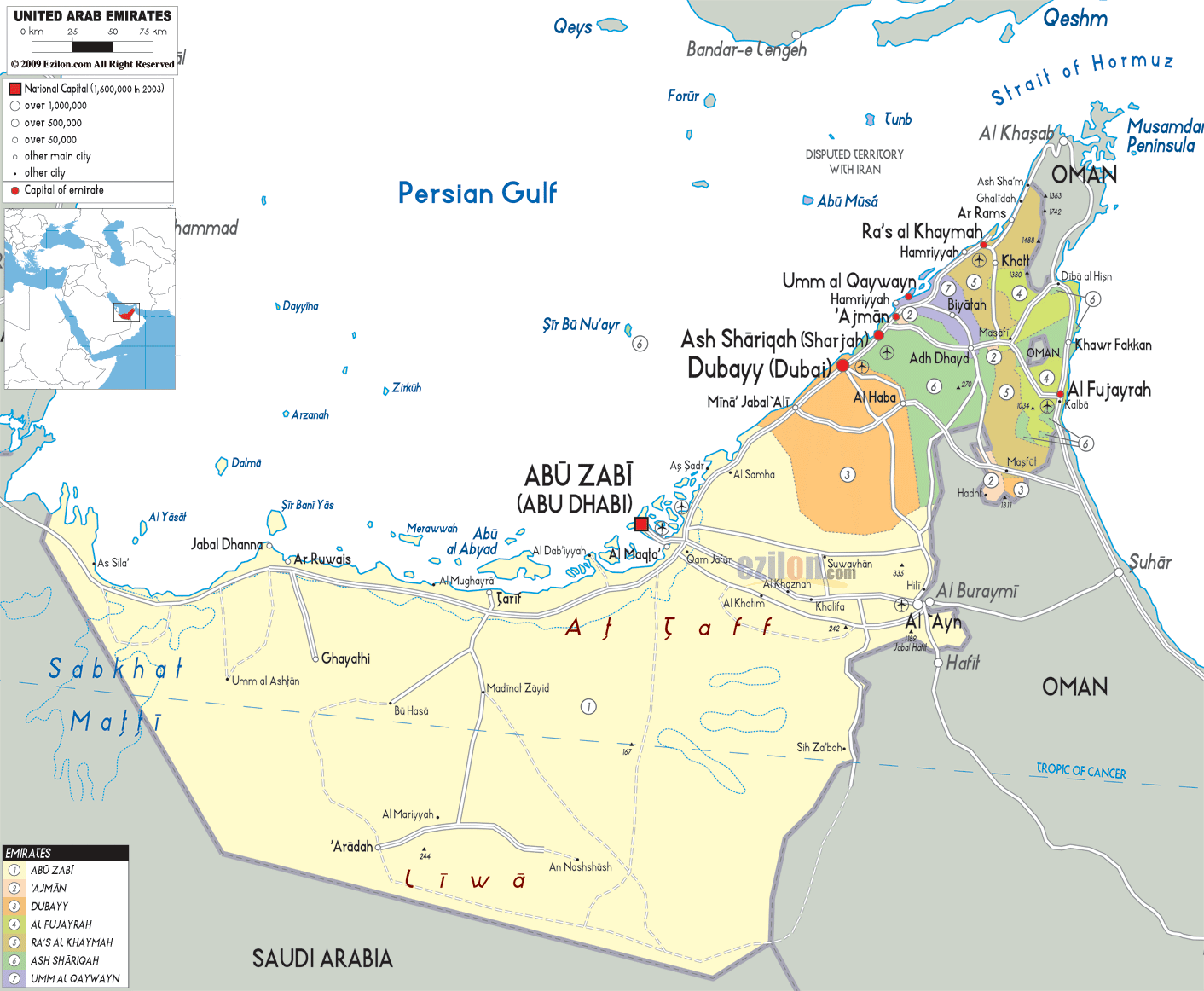
Description: Detailed map of United Arab Emirates with cities, towns, emirates, villages and surrounding countries. It shares borders with Saudi Arabia and Oman.
This map of United Arab Emirates with cities, emirates, and towns is already large enough to read directly on your desktop. To see a full-screen zoom view on a phone or tablet, tap the map image (or tap the Zoom Map label above the image). Scan by shading emirates in various colored blocks, with United Arab Emirates's cities and towns in bold.
The Map of the United Arab Emirates (UAE) reveals a highly structured, strategically located country on the southeastern edge of the Arabian Peninsula, where land, sea, and desert converge into a dynamic landscape of modern cities and natural terrain. As you move along the map visually, it becomes clear that the UAE is developing along the Persian Gulf.
It is a continuous corridor developing along the coast. Here we witness the big cities, emirates, and economic centres closely interlinked. This detailed map of the UAE, with cities and regions, shows not only political boundaries but also the relationships among coastal settlements, inland desert zones, and mountainous regions that define the country's geography.
Looking closely at the western side of the map, the vast territory of Abu Dhabi dominates the landscape. The emirate spans most of the UAE's territory and is characterized by vast desert plains, scattered roadside settlements, and highways linking the remotest areas to the capital, Abu Dhabi.
The capital city is located on the seashore, has islands within its territories, and is connected to neighbouring islands by bridges. Moving inland from the coast, the map highlights cities such as Al Ain, near the border with Oman, where oasis-based settlement patterns contrast sharply with the surrounding desert.
As your eye travels northeast along the coastline, the map transitions into the dense urban region that includes Dubai, one of the most recognizable cities in the world. On the map, Dubai is visible right between Abu Dhabi and Sharjah, along with road networks running parallel to the sea. The city's coastal location suggests the presence of Jebel Ali, one of the largest ports in the UAE, and of Dubai's status as a trading hub. The map depicts a more extensive metropolitan area (upper right) regarded as urban complex zones. Areas such as Al Barsha, Deira, and Bur Dubai further complicate this.
As one moves further along the coast, one finds that the emirate of Sharjah serves as a central link in the UAE. Sharjah will be seen on the map, with its peculiar position extending to the Persian Gulf and the Gulf of Oman, joining the western and eastern parts of the country. The eastern coastal sites, Khor Fakkan and Kalba, are hilly but are gaining significance in Sharjah, UAE. The dual coastline is one of the unique characteristics that is easily recognisable in the UAE map. It states territorial complications.
Ajman is a small emirate positioned between Sharjah and Umm Al Quwain. Although urbanized and compact, it plays an important role in extending the urban belt along the coast. The close relationship among the emirates is evident in Ajman, where urban development often flows from one emirate into another.
Umm Al Quwain is situated just to the north of Ajman. And it is a calmer area with a slower pace of development. The site remains connected to the national infrastructure through a series of highways and road networks.
At the north of the map, Ras Al Khaimah is visible as it extends into the Strait of Hormuz, one of the world's most diverse waterways. Ras Al Khaimah is bordered by a mountain range, especially as you approach Oman.
It is very striking that the flat desert characterising the UAE suddenly gives way to mountains in the east. Within the regional structure, Al Dhait, Al Rams, and Khatt are some of the cities. Also, the emirate's coastal access adds to its importance for trade and maritime activity.
The emirate of Fujairah is on the east side of the UAE map within the UAE, but is away from the country map due to the Hajar Mountains. Due to its location on the Gulf of Oman, Fujairah has direct access to the Indian Ocean and all global shipping routes; however, it lies outside the Strait of Hormuz. Cities like Dibba, Masafi, and Al Bidyah are located in the area and contribute to the emirate's geographic and economic identity.
The UAE map shows widespread development in Dubai, Sharjah, Abu Dhabi, and Ajman, with development gradually decreasing towards the interior. The cities of Abu Dhabi, Dubai, Sharjah, Ajman, Ras Al Khaimah, and Umm Al Quwain are arranged along a linear belt that represents the urban growth centre's spine along the Persian Gulf coast. The seaside orientation is not by chance, but rather due to the importance of trade, fishing, and the ports.
Each of these cities is connected by a major highway, which is the focus of this map. This road-light map simplifies but shows how the UAE functions as one. An example of a road is the E11, which runs parallel to the coast and connects Abu Dhabi to Dubai and beyond.
The coastal strip only represents a section of the desert, the map indicates. This area included the cities of Madinat Zayed, Liwa, and Ruwais, Abu Dhabi, located along major roads. The Liwa Oasis is situated in southern Abu Dhabi at one of the most important human settlements in the desert. The Liwa Oasis connects the UAE to Saudi Arabia.
The eastern interior of the country hosts the major cultural and historical centre, the city of Al Ain. The unique feature of the asteroid on the map is also its proximity to the Oman border, in addition to its greenery, which is due to underground water. The roads connecting there to Abu Dhabi and Dubai indicate that it is a secondary urban center in the UAE.
The Fujairah and the bordering parts of Sharjah are separated from the rest of the UAE by the Hajar Mountains, which naturally line the eastern part of the UAE. The map shows how the mountainous terrain shapes the climate, water resources, and settlement patterns in the area.
Cities such as Masafi, located within the mountain region, act as important transit points between the east and west coasts. The presence of these mountains adds geographic diversity to the UAE, contrasting sharply with the flat desert plains that dominate the rest of the map.
The UAE's location along the Persian Gulf and the Gulf of Oman places it at the center of global trade routes. The map shows where the country is located near the Strait of Hormuz, through which much of the world's oil passes. The UAE's position is further strengthened by its strategic location.
The Emirates lie to the south and west of Saudi Arabia and to the east of Oman. The borders shown on the map give the relative position of the country in the Middle East. The fact that other Gulf states, such as Qatar and Bahrain, are close by helps show what a centre the UAE has become.
Throughout the UAE map, numerous cities and towns contribute to the country's geographic and economic structure. These include:
Abu Dhabi, Al Ain, Ruwais, Madinat Zayed
Dubai, Deira, Jebel Ali
Sharjah, Khor Fakkan, Kalba
Ajman
Umm Al Quwain
Ras Al Khaimah, Al Rams
Fujairah, Dibba, Masafi
The UAE's identity is shaped by these places - economically, socially, and geographically, which are the scenes where things evolve, and mechanisms move.
The Map of the United Arab Emirates (UAE) provides a comprehensive view of a country that combines modern cities, strategic geography, and diverse natural landscapes. The vast desert of Abu Dhabi, the bustling cities of Dubai and Sharjah, the mountainous Fujairah, and the coastal ports of Ras Al Khaimah all mean different things depending on the part of the map. The map represents connectivity, increased economic activity, and geographical significance.
This map can help you reach your destination. Through this map, the user will also become familiar with how geography shapes the economy, culture, and the UAE's global role.
The UAE is located in the Middle East on the southeastern Arabian Peninsula, bordered by Saudi Arabia and Oman, with coastlines along the Persian Gulf and Gulf of Oman.
Abu Dhabi is the capital city and appears prominently on the western coastline as the largest emirate.
Seven emirates are shown: Abu Dhabi, Dubai, Sharjah, Ajman, Umm Al Quwain, Ras Al Khaimah, and Fujairah.
Dubai lies along the Persian Gulf coast between Abu Dhabi and Sharjah and serves as a central hub.
Abu Dhabi occupies the western and southern UAE and dominates the map by size.
Sharjah is north of Dubai and uniquely spans both coasts.
Fujairah lies on the eastern side along the Gulf of Oman.
Abu Dhabi is the largest emirate by land area.
Ajman is the smallest emirate.
Major cities include Abu Dhabi, Dubai, Sharjah, Al Ain, Ras Al Khaimah, Fujairah, Ajman, and Umm Al Quwain.
Al Ain is located inland near the Oman border and is a major cultural city.
It lies in the far north near the Strait of Hormuz.
The UAE borders the Persian Gulf and Gulf of Oman.
A globally important shipping route near the UAE.
Yes, the Hajar Mountains appear in the east.
Yes, desert areas dominate the interior regions.
They are connected by highways and road networks.
It is known for its quieter coastal setting.
Ajman lies between Sharjah and Umm Al Quwain.
A Sharjah city on the Gulf of Oman coast.
They support trade, tourism, and logistics.
It features desert plains and coastal islands.
Dubai blends urban coastline and desert.
Mountainous terrain with coastal access.
Saudi Arabia and Oman border the UAE.
Yes, it helps understand routes and city positions.
Yes, it supports geography learning.
Yes, boundaries are clearly outlined.
Yes, key roads are shown for orientation.
No. Printing or copying maps from this site is not permitted.

Physical Map of United Arab of Emirates
Physical map and map image of United Arab of Emirates.

Road Map of United Arab of Emirates
Road map and map image of United Arab of Emirates.

Regional Directory of United States of America
Information and guide about United States of America and websites with American topics.

Regional Directory of Europe
Information and guide about Europe and websites with European topics.

Regional Directory of Australia
Information and guide about Australia and websites with Australian topics.