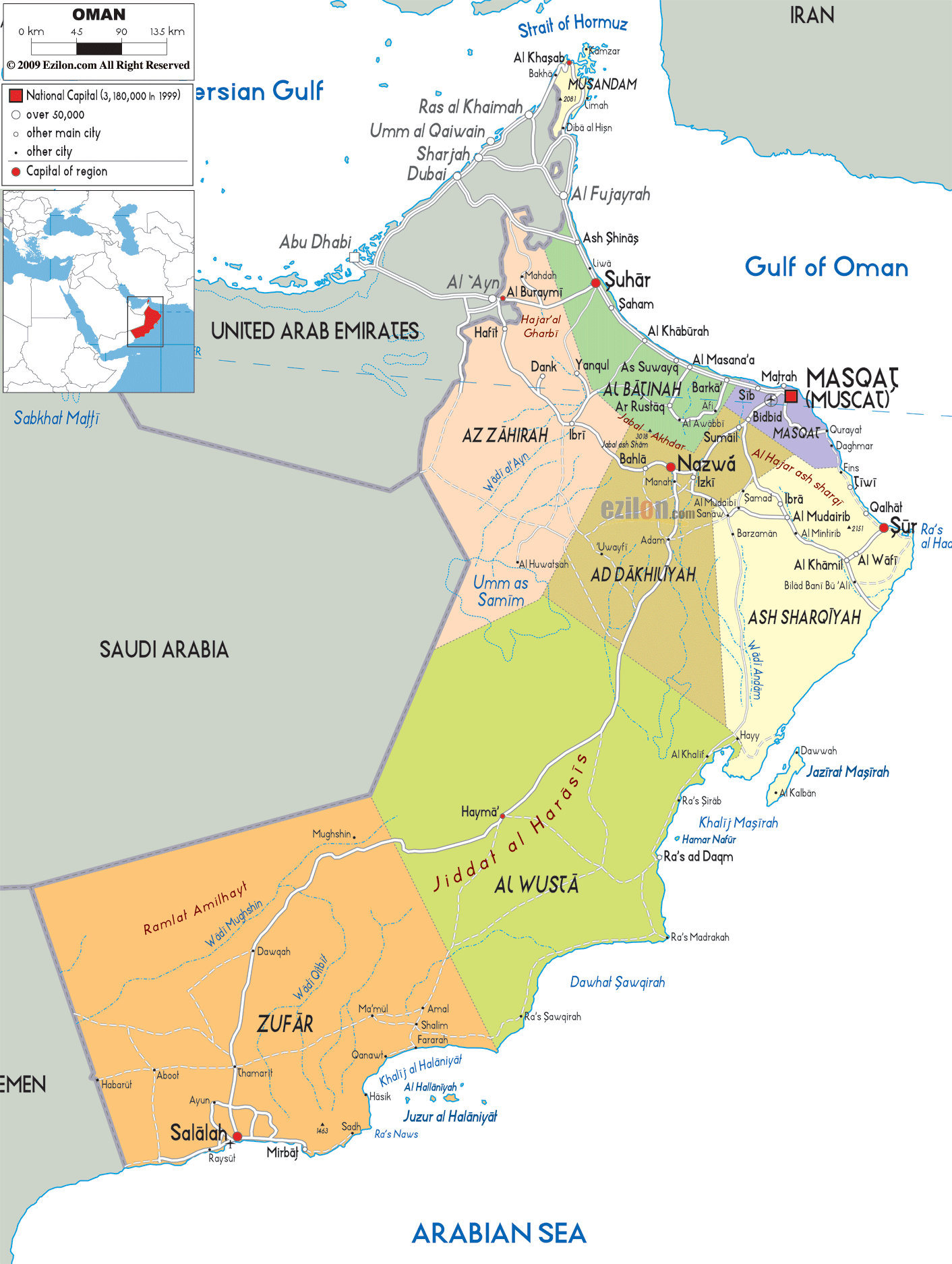
Description: Detailed large political map of Oman showing names of capital city, towns, states, provinces and boundaries with neighbouring countries.
This map of Oman with cities, governorates, and towns is already large enough to read directly on your desktop. To see a full-screen zoom view on a phone or tablet, tap the map image (or tap the Zoom Map label above the image). Scan by shading governorates in various colored blocks, with Oman's cities and towns in bold.

The map of Oman with major cities provides a comprehensive view of the Sultanate of Oman, a sovereign nation occupying the southeastern corner of the Arabian Peninsula in Western Asia. As you trace the map with your eyes, you notice immediately the strategic location of Oman between the Arabian Sea, the Gulf of Oman, and the Strait of Hormuz, which is important for shipping routes. This informative map helps readers better understand the country's layout and how cities, areas, and physical features are connected.
Situated at the very top of the map, Oman borders the United Arab Emirates to the north, Saudi Arabia to the west, and Yemen to the southwest. The neighboring countries help showcase Oman's geopolitical importance, especially in regional Middle Eastern mapping.
A map of Oman divides the country into so-called regions, or governorates, as they are often referred to. These regions have different terrain, varied settlement patterns, and varying degrees of road access.
As your eyes move to the northeastern coastline, you will find Masqat (Muscat) clearly marked as the national capital. The map shows Muscat, a coastal city on the Gulf of Oman. So, it signifies Oman's connectivity to international trade and maritime routes.
Notably, Muscat has a metropolitan corridor of urban areas, including Bawshar, As Sib, and Qurayyat. This region is the densest part of the country and its political, economic, and cultural center.
The road-light network visible on the map shows how Muscat connects inland toward Nizwa and outward toward coastal towns like Sur. Even though the roads are not heavily detailed, the main routes clearly guide the viewer across the country's most important connections.
Moving northwest from Muscat, the map reveals the Al Batinah region, which stretches along the coast toward the UAE border. This is one of the most agriculturally productive areas in Oman, benefiting from coastal plains and access to water.
Cities such as Suhar, Saham, and Barka are prominently featured, forming a chain of settlements along the coast. Suhar, in particular, stands out as a major industrial and port city, reinforcing Oman's economic development along this coastal belt.
The map visually shows how this region serves as a transition zone between the mountains inland and the sea, making it one of the most livable and developed areas in Oman.
At the top of the map, separated from the rest of Oman by UAE territory, lies the Musandam Peninsula. This unique geographic feature is clearly labeled and surrounded by the waters of the Strait of Hormuz.
The towns of Khasab and Dibba appear here, highlighting the region's sparse population but immense strategic importance. The map shows rugged coastlines and fjord-like inlets, making Musandam one of the most visually striking regions.
This area plays a critical role in global oil shipping, as the Strait of Hormuz is one of the world's most important maritime chokepoints.
After Muscat, we again reach the earlier regions of Oman, the Ad Dakhiliyah map. This area is historically very significant in Oman. At the center is a big city named Nizwa
Nizwa is culturally and historically important in Oman, as evidenced by its location as a hub connecting northern and southern Oman. Roads from Muscat, Al Batinah, and Al Sharqiyah all converge here, making it a key junction.
The surrounding terrain shows a mix of mountains and valleys, indicating fertile areas where settlements have historically developed.
As you move eastward on the map, the region of Ash Sharqiyah becomes visible, stretching along the coastline toward the Arabian Sea. The pattern of settlements includes cities such as Sur, Al Kamil, and Jaalan, which are located in both coastal and inland zones.
As a historic port city, Sur's location on the map highlights its maritime importance. The roads linking Sur to Muscat and to inland areas illustrate how this region connects the coast and the desert.
Further into the map, the sandy space depicts a desert. Here, human settlement is getting more sparse.
The central portion of the map is dominated by Al Wusta, a vast and sparsely populated region. This area includes features such as Jiddat al Haras s, clearly labeled on the map.
Unlike the coastal regions, Al Wusta has very few major cities, with Haima among the key settlements. The map shows long stretches of open desert, reinforcing the region's isolation.
Despite its low population, Al Wusta plays an important role in wildlife conservation and oil production, making it economically and environmentally significant.
At the southern end of the map lies Zufar (Dhofar), one of Oman's most unique regions. The city of Salalah is prominently marked along the coast of the Arabian Sea.
Unlike the rest of Oman, Dhofar experiences seasonal monsoon rains, which transform the landscape into a lush green environment. This contrast is visible on the map, where the terrain appears more fertile compared to the northern desert regions.
The road network connects Salalah to the interior and to the Yemeni border, confirming its status as a southern gateway.
This map does not show Oman in isolation. It places Oman firmly within its regional context by clearly labeling all neighboring countries:
United Arab Emirates to the northwest
Saudi Arabia to the west
Yemen to the southwest
United Arab Emirates (UAE): Shown along the entire northwestern border, with UAE cities such as Abu Dhabi, Dubai, Sharjah, Ras al Khaimah, Umm al Qaiwain, Al Fujayrah (Fujairah), and Al Ayn (Al Ain) all visible just across the border. This confirms the close geographic and economic relationship between Oman and the UAE.
These borders help define Oman's position within the Middle East and show how it connects to the broader region.

Physical Map of Oman
Physical map and map image of Oman.

Road Map of Oman
Road map and map image of Oman.

Regional Directory of United States of America
Information and guide about United States of America and websites with American topics.

Regional Directory of Europe
Information and guide about Europe and websites with European topics.

Regional Directory of Australia
Information and guide about Australia and websites with Australian topics.