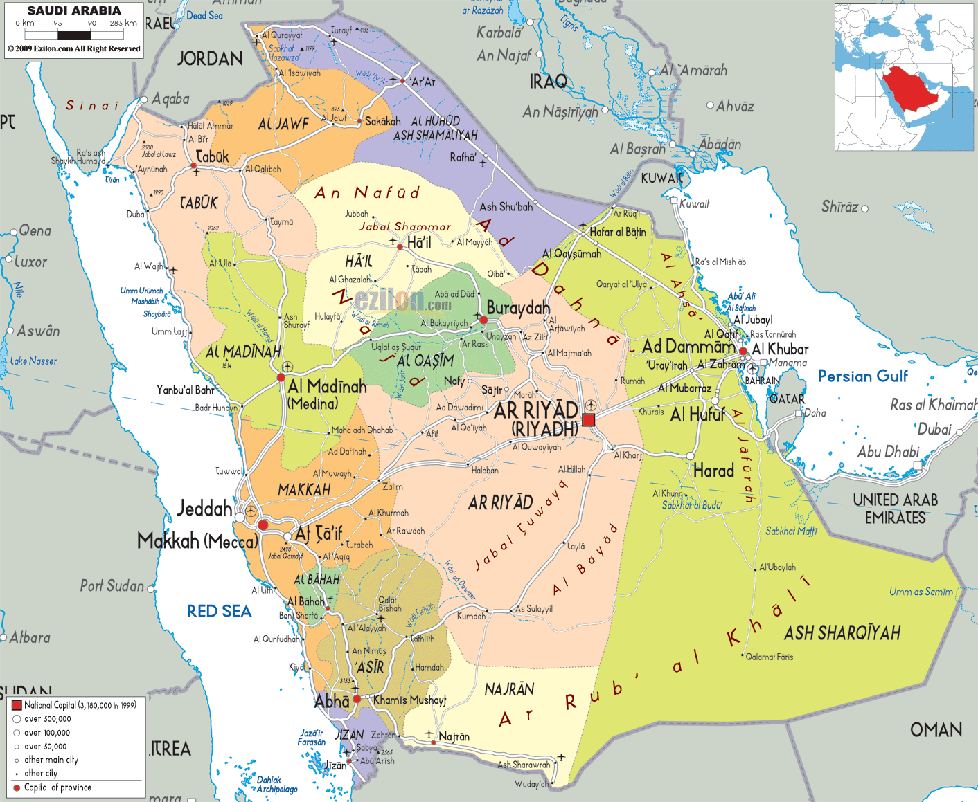
Description: Detailed large political map of Saudi Arabia showing names of capital city, towns, states, provinces and boundaries with neighbouring countries.
This map of Saudi Arabia with cities, provinces, and towns is already large enough to read directly on your desktop. To see a full-screen zoom view on a phone or tablet, tap the map image (or tap the Zoom Map label above the image). Scan by shading provinces in various colored blocks, with Saudi Arabia's cities and towns in bold.

Detailed map of Saudi Arabia with cities, towns, provinces, villages and surrounding countries. Saudi Arabia shares borders with Jordan, Iraq, Kuwait, Qatar, the United Arab Emirates, Oman, and Yemen. These various areas also have different population densities. It's not only a country map. Rather, it's a map of Saudi Arabia showing its cities and regions, along with its geographical features.
From the western coast of the Red Sea to the eastern coast of the Persian Gulf, the map spans a wide expanse, including mountains, deserts, coastal plains, and major urban centers. The positioning of Saudi Arabia also becomes very clear when you observe its borders. The map shows how the Kingdom connects to Jordan, Iraq, Kuwait, Qatar, the United Arab Emirates, Oman, and Yemen, making it one of the most central countries in the region. This central location is critical for trade routes, cultural exchange, and geopolitical influence.
As you continue observing the map, the use of color-coded regions becomes especially useful. Each administrative region is clearly separated, allowing you to visually distinguish areas such as Ar Riyad, Makkah, Al Madinah, Ash Sharqiyah, Asir, Najran, and Tabuk. This regional emphasis helps the reader move beyond simple geography and into a deeper understanding of how Saudi Arabia is organized internally.
In the center of the map lies the Ar Riyad region, and in the center of this region lies the capital, Riyadh. Riyadh's location at the heart of Saudi Arabia is not accidental, as it is the country's political, administrative, and economic centre. When you look closely at the map, you can see how major routes radiate outward from Riyadh, connecting it to nearly every other region.
Riyadh's central position makes it a link or bridge between the religious regions of the west, the industrial east, and the north and south. In the vicinity of Ar Riyad, a contemporary urban expansion interspersed with vast tracts of land is underway. This suggests that the development is localized, while the surrounding areas are characteristic of the Arabian Peninsula.
The Riyadh Outline Map shows all the small towns and settlements that are economically and administratively dependent on Riyadh. This shows that Riyadh is not simply a city; it is a centre that sustains a much larger network.
Moving westward across the map, you enter the Makkah region, which stands out as one of the most globally recognized areas in Saudi Arabia. This region contains the holy city of Makkah (Mecca) and the major coastal city of Jeddah, both of which are clearly marked on the map.
Jeddah's position along the Red Sea is especially important. As you follow the coastline on the map, you can see how Jeddah acts as a major entry point into the country, connecting Saudi Arabia to international maritime routes. This coastal alignment also makes it a key center for trade, tourism, and transportation.
The map reveals how the terrain changes as you move inland from Jeddah toward Makkah. The map shows how the coastal plains rise slowly into the mountainous regions and vice versa. The transition is not merely geographical but also cultural and historical; the region combines contemporary urban living with ancient pilgrimage routes.
North of the Makkah region, the map highlights the Al Madinah region, home to the city of Medina. This city is one of the most significant religious centers in the world, and its location on the map shows how it connects the western coastline with the northern interior of Saudi Arabia.
The road-light network visible on the map demonstrates how Medina is linked to surrounding regions such as Tabuk and Ha'il. Al Madinah, being interlinked with other parts of the Kingdom, is further enhanced by this road.
Compared to Riyadh or Jeddah, the surrounding area is less built up, but its location makes it an important centre for both religious and regional movement.
As you shift your attention to the eastern side of the map, you encounter Ash Sharqiyah, the Eastern Province of Saudi Arabia. This region is one of the most economically vital areas in the entire country, and the map makes this very clear by highlighting major cities such as Ad Dammam, Al Khobar, and Al Jubayl.
The cities are situated on the coast of the Persian Gulf, making an industrial and urban strip. The map illustrates how these coastal cities are linked to each other through road networks and also to Riyadh. This helps with the movement of goods, workers, and resources, especially in the energy sector.
The interior of Ash Shaqiyah gradually becomes desert as one moves away from its developed coastal areas into the sparsely populated interior. The contrast appears throughout the Saudi Arabian map repeatedly as a motif.
Head up northwest of Ri adh on the map, and you will reach Al Qasim, a very productive agricultural region. Buraydah city is well identified as the administrative and economic hub of the region.
Al Qasim is important as it serves as a crossing point for several of the region's most important roads. The region's freight transport network enables haulage from neighbouring areas of Riyadh and Ha'il.
Unlike coastal areas, Al Qasim is more associated with its identity and settlement patterns in agriculture. The map shows the positions and densities of the settlements.
Further north, the Ha'il region lies near desert formations such as An Nafud. The city of Ha'il is clearly marked, and its location underscores its importance as a gateway to northern Saudi Arabia.
The surrounding desert landscape dominates the map in this area, emphasizing the region's connection to traditional Arabian geography. At the same time, Ha'il acts as a bridge between central Saudi Arabia and the northern border regions.
At the far northwest of the map lies the Tabuk region, which borders Jordan and sits near the Gulf of Aqaba. The city of Tabuk is shown as a key urban center in this area.
This region is particularly important because it connects Saudi Arabia to neighboring countries and provides access to coastal and inland routes. The map highlights how Tabuk's position allows it to serve as both a gateway and a defensive frontier.
In the southern part of the map, you find Asir, Jizan, and Najran, regions that are very different from the central desert areas. The locations of cities such as Abha, Jizan, and Najran show a new geographical reality.
The map reflects the shading and configuration of valleys, mountains, and moderately mild conditions. Compared to any other desert regions of the world, they are more populated and have agriculture and an economy.
The proximity of these areas to Yemen also underscores their significance for cross-border linkages and regional connectivity.
Saudi Arabia's map shows its neighboring countries and the connections it has with them. This helps reinforce its position as the Middle East's central hub.
Every single border is labeled to explain the relationship between Saudi Arabia and the surrounding countries.
Saudi Arabia is located in the Middle East and occupies most of the Arabian Peninsula, bordered by several countries and surrounded by major seas.
Riyadh is the capital city and serves as the political and economic center of Saudi Arabia.
The Red Sea borders the west while the Persian Gulf borders the east.
Regions include Riyadh, Makkah, Madinah, Eastern Province, Qasim, Tabuk, Asir, Najran and more.
Riyadh is centrally located and connects all major regions through road networks.
Jeddah lies on the Red Sea coast and serves as a major port city.
Makkah is located inland from Jeddah in western Saudi Arabia.
Al Madinah is a major religious city and key regional hub.
The Eastern Province is the oil-rich region along the Persian Gulf.
Dammam, Khobar and Jubail are key cities.
Al Qasim is known for agriculture and central location.
Ha'il is located in northern Saudi Arabia near desert regions.
Tabuk is located in the northwest near Jordan.
Southern regions include Asir, Jizan, and Najran.
Abha is in the mountainous Asir region.
Jizan lies along the Red Sea coast in the southwest.
Najran is a southern region bordering Yemen.
The Rub’ al Khali is the largest desert.
An Nafud is a northern desert region.
Through highways and road networks.
The Riyadh region is most populated.
Coastal plains and mountains.
Coastal and industrial zones.
Desert plateau.
Jordan, Iraq, Kuwait, Qatar, UAE, Oman, Yemen.
Ports and coastal cities.
Industrial and oil regions.
Deserts, plateau and coastlines.
Yes for study and travel planning.
No. Printing or copying is not permitted.

Physical Map of Saudi Arabia
Physical map and map image of Saudi Arabia.

Road Map of Saudi Arabia
Road map and map image of Saudi Arabia.

Regional Directory of United States of America
Information and guide about United States of America and websites with American topics.

Regional Directory of Europe
Information and guide about Europe and websites with European topics.

Regional Directory of Australia
Information and guide about Australia and websites with Australian topics.