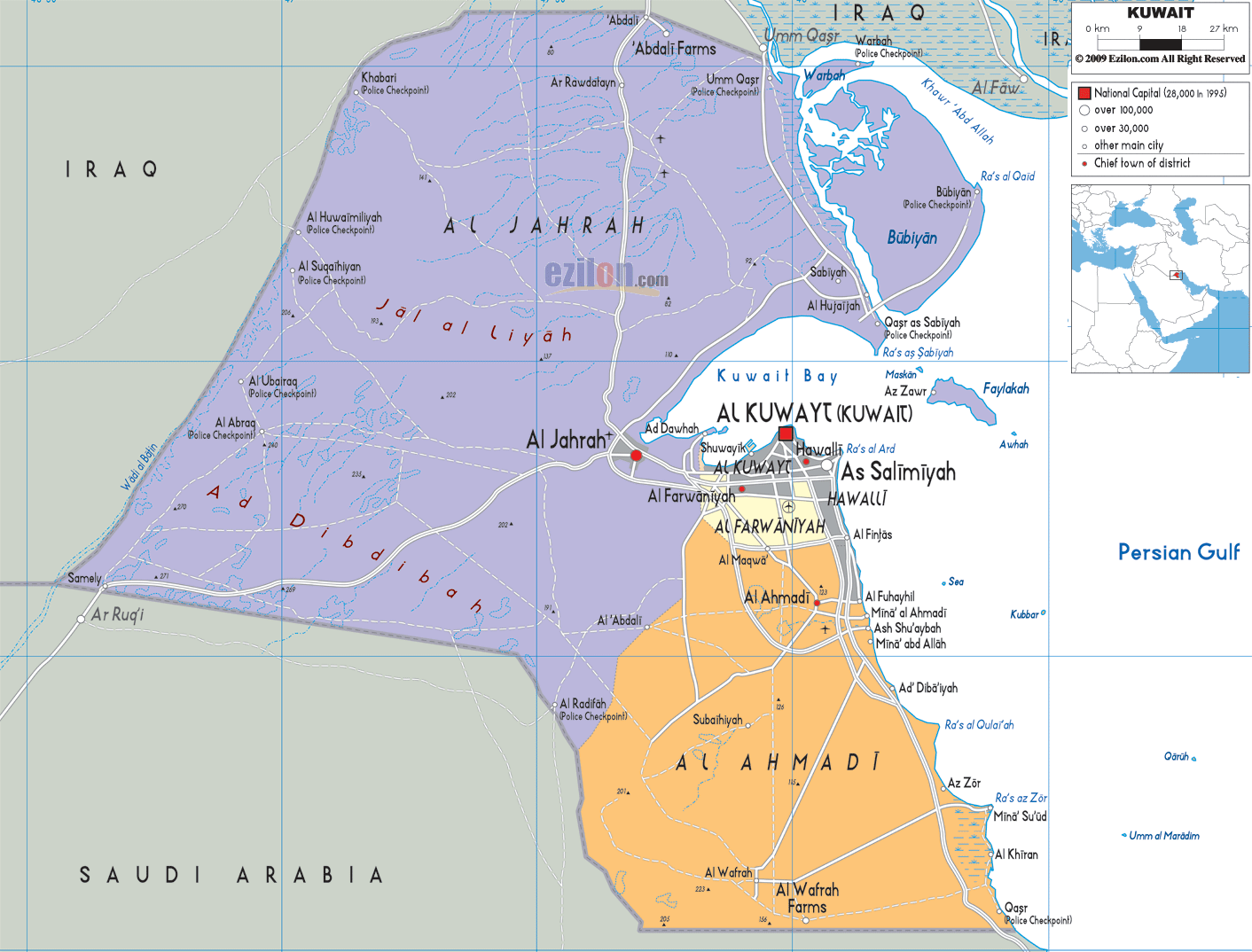
Description: Detailed large political map of Kuwait showing names of capital city, towns, states, provinces and boundaries with neighbouring countries.

The Map of Kuwait with cities, major cities, and road network offers a highly detailed map of Kuwait that clearly and structurally captures the country's full geographic layout. As you follow the map from north to south and west to east, Kuwait is a small Gulf country where littoral development, desert topography, and urban planning combine to create a strong spatial order.
A map of Kuwait shows the cities of Kuwait City (Al Kuwayt), Hawalli, As Salimiyah, Al-Farwaniyah, Al-Ahmadi, and Al-Jahrah. Furthermore, the Kuwait map shows the major regions of Kuwait, including Al-Jahrah (northwest), Al-Asimah (the capital), Hawalli (the coastal urban belt), Farwaniyah (the central expansion), and Ahmadi (the southern industrial zone). The use of color in each region visually separates them, giving the reader an idea of how population density and land use vary across the country.
Although in road-light form, the road network of Kuwait makes it clear how other places are connected. The major routes from Kuwait City extend westward toward Jahrah, southward toward Ahmadi, and along the coast toward the Persian Gulf. These successes help depict travel patterns, urban expansion, and regional links.
The map clearly places Kuwait along the northwestern edge of the Persian Gulf, which plays a major role in shaping its economy, climate, and settlement patterns.
To the north and northwest, Kuwait borders Iraq, visible on the map beyond the northern desert region
To the south, it borders Saudi Arabia, where the desert landscape continues seamlessly
To the east, Kuwait opens to the Persian Gulf, where the coastline curves around Kuwait Bay
The map shows Kuwait Bay as an important feature, creating a natural indentation on the coastline where Kuwait City is located. Throughout much of South Africa, particularly in the eastern coastal areas, cities are located and populated.
Al Jahrah is the largest region in Kuwait in the northwestern part of the map. The map depicts the area as predominantly desert and less urbanised vis-à-vis the coastal area.
The map of the Kuwait desert is full of plains with numerous settlements, among them Al Jahrah town, which is part of the Kuwait desert. The roads here are few and long, connecting all the points rather than being close to one another.
Due to the low population and proximity to the Iraqi border, this area is strategically important.
The map also highlights Bubiyan Island, located in the northeastern corner near Iraq. This large island adds to Kuwait's coastline's geographic complexity.
Although not heavily urbanized, its presence on the map shows Kuwait's maritime extension into the Gulf and its proximity to important waterways.
At the center of the map, Kuwait City stands out as the capital and most important city. Its position along Kuwait Bay makes it the focal point for economic, administrative, and cultural activity.
The Kuwait City map view shows roads radiating outward in all directions, connecting it to all major regions. Surrounding districts such as Shuwaikh, Dasman, and Al Kuwayt metropolitan areas form a dense urban cluster.
This central concentration reflects Kuwait's reliance on a single dominant urban hub.
Moving down the coast, Hawalli and As Salimiyah, two densely populated places, are shown on the map of Kuwait.
The cities have grown together into one neighbourhood on the Persian Gulf coastline, with buildings close-packed and roads intensively linked. According to the Kuwait coastal cities map, the residential and commercial zones of this region benefit from proximity to the sea. The Kuwait coastal cities map shows how this region serves as both a residential and commercial zone, benefiting from proximity to the sea.
Just south of Kuwait City, Al Farwaniyah appears as a transitional region. The map shows it acting as a bridge between the central urban area and the southern industrial zones.
This region is well connected by roads, supporting residential expansion and infrastructure growth.
Further south, Al Ahmadi becomes the dominant region. The map shows cities such as Al Ahmadi, Fahaheel, and Sabahiya forming a cluster of settlements tied to Kuwait's oil industry.
The Kuwait oil region map features highlight how infrastructure and urban development are concentrated around industrial zones, making this region critical to the national economy.
At the southernmost part of the map, areas such as Al Wafrah farms are shown, indicating limited agricultural activity in the desert environment.
The road network here becomes sparse, with longer distances between settlements, reflecting low population density.
The map of Kuwait, with towns and governorates, shows how the area is divided by population, economic activity, and geographical features. A close examination of the map shows that the governorate is different in terms of population density, infrastructure, and land utilisation.
Since Kuwait is a small country, all regions are well connected and uniformly spaced, so even the furthest areas are linked by a central network extending from Kuwait City.
The Capital Governorate (Al Asimah) is the most important region in the AP. The political, financial, and cultural centre of Kuwait is its capital, Kuwait City.
The section on the Kuwait capital map includes many roads, buildings, and urban agglomerations. Activities result in the application being useful for one another. The roads are closely spaced, forming a grid pattern to allow heavy traffic and everyday use.
This region is home to government institutions, major businesses, and key infrastructure, making it the most influential area in Kuwait.
The Hawalli area is one of Kuwait's densely populated regions. The cities of Hawalli and Salimiyah are forming an unbroken urban strip along the coast.
The dense settlement pattern and good road connectivity are evident in the urban density map of Kuwait. The proximity to the Persian Gulf enhances this region's appeal, making it a popular residential and commercial area.
This region represents modern urban Kuwait, where development is continuous and highly integrated.
The Farwaniyah site is an outgrowth of the main urban core. It is a major area of population growth and infrastructure development.
The map showing the major roads from Farwaniyah to Kuwait City, Hawalli, and Ahmadi indicates it is a connector region. This necessitates transportation nd logistics within Kuwait.
Kuwait's industrial hub is considered the Ahmadi region. Cities such as Fahaheel and Al Ahadi line the southern coast, as shown on the map.
The Kuwait industrial zones map illustrates how this area is organized around oil-producing and exporting facilities. The roads here are designed for industrial transport linking refineries, ports, and settlements.
This area is an important segment of the Kuwait economy, and its position on the map shows that.
The Jahra region covers the largest land area in Kuwait but has the lowest population density. The map clearly shows vast desert landscapes with minimal urban development.
The Kuwait desert geography map emphasizes how this region differs from the rest of the country. Roads are long and widely spaced, connecting only key points such as Al Jahrah town.
Its proximity to Iraq adds strategic significance, making it important for border security and regional connectivity.
The map highlights Kuwait Bay as a central coastal feature. This natural harbor supports maritime activity, which explains why Kuwait City developed here.
Further south, the coastline continues along the Persian Gulf, where industrial ports and coastal cities are located. This coastal access is essential for trade and economic activity.
To fully understand this detailed Kuwait map with cities, follow this approach:
Start at Kuwait City (center)
Move north to the Jahra desert region
Explore east toward Kuwait Bay and coastal areas
Move south through Hawalli and Farwaniyah
Continue to the Ahmadi industrial zone
End in the southern rural areas
This best map of Kuwait with cities and road network is essential for:
Awareness of distances and paths.
Pupils learning about Middle East geography.
Urban development research.
Residents are getting to grasp the structure of the area.
The map balances clarity, accuracy, and usability, making it highly effective for both learning and navigation.
The map shows regions, cities, Kuwait Bay, and road connections.
Along Kuwait Bay on the eastern coast.
Kuwait City.
South of Kuwait City.
In southern Kuwait.
In western Kuwait.
Iraq and Saudi Arabia.
On the eastern coast.
In northeastern Kuwait.
Main routes connecting cities.
Central coastal region.
Desert regions.
South of Kuwait City.
In southern Kuwait.
In Ahmadi region.
Near Saudi border.
Desert terrain.
Urban coastal development.
It is the national hub.
No. Printing or copying maps is not permitted.

Physical Map of Kuwait
Physical map and map image of Kuwait.

Road Map of Kuwait
Road map and map image of Kuwait.

Regional Directory of United States of America
Information and guide about United States of America and websites with American topics.

Regional Directory of Europe
Information and guide about Europe and websites with European topics.

Regional Directory of Australia
Information and guide about Australia and websites with Australian topics.