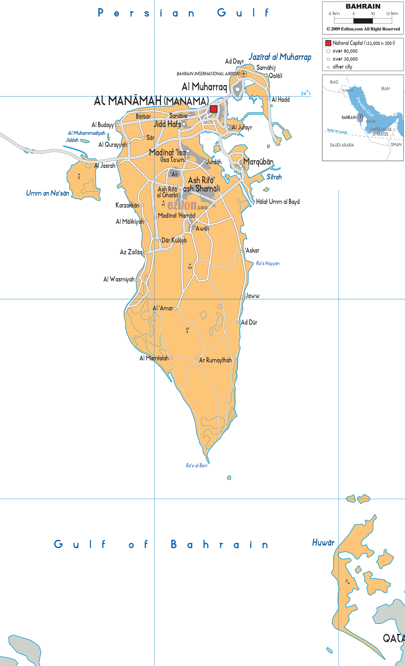
Description: Detailed large political map of Bahrain showing names of capital city, towns, states, provinces and boundaries with neighbouring countries.
This map of Bahrain with cities, governorates, and towns is already large enough to read directly on your desktop. To see a full-screen zoom view on a phone or tablet, tap the map image (or tap the Zoom Map label above the image). Scan by shading governorates in various colored blocks, with Bahrain's cities and towns in bold.

The Map of Bahrain with cities, major cities, and road network presents a clear, highly detailed map of this island nation, allowing readers to understand its geography in a way that feels both intuitive and immersive. A closer look at the map shows that Bahrain isn't just one landmass but an island group. Urbanization must have occurred in a compact area, with the rest being clear and mostly unadopted.
This best map of Bahrain is designed to guide your eyes naturally across the country, starting from the densely built northern regions and gradually moving toward the quieter southern landscapes. Instead of overwhelming the reader with excessive road details, the map uses a road-light network, which provides just enough orientation to understand how cities connect while keeping the focus on major cities, administrative regions, and coastal geography.
For residents, this map helps identify neighborhoods and city relationships. For tourists, it provides a clear understanding of direction and distance. The Bahrain map offers a simplified but accurate representation of the country's space and can help students and researchers understand how Bahrain is organized.
On the map, you can see that the Persian Gulf borders Bahrain. The country's development, economy, and everyday life are closely tied to its geography. The northern edge of the map opens into the wider Gulf, while the southern portion transitions into the Gulf of Bahrain, a slightly more enclosed body of water.
The coastline is not smooth or uniform. In contrast, it has more curves, inlets, and extensions in the north and east above. Bahrain's coastline is marked by natural formations on the beach and land reclamation activities that made the beach more usable.
Although Bahrain is an island nation, it is closely connected to its neighbors. The map places Bahrain in a broader regional context, showing its proximity to:
Saudi Arabia, located directly to the west, is connected by the King Fahd Causeway
Qatar, visible to the southeast across the water
Iran, located across the Persian Gulf to the north
This positioning explains why Bahrain has long served as a strategic hub for trade, finance, and transportation in the Middle East. Even though these neighboring countries are not fully detailed on the map, their relative placement helps you understand Bahrain's importance in the region.
At the center of the northern region, the map clearly highlights Al Manamah (Manama), the capital city. This area stands out not just because it is marked as the national capital, but also because of the dense cluster of surrounding urban areas that connect seamlessly with it.
Manama is the political, economic, and cultural center of Bahrain. On the map, it appears as a focal point from which roads and urban zones radiate outward. The density of labels in this area reflects the region's high population density and its importance in daily life.
As you move your eyes slightly outward from Manama, you begin to notice how closely connected the surrounding towns are. Locations such as Jidd Haffs, Sanabis, Barbar, and Saar are not isolated settlements. They merge into a single, long urban corridor with no clear physical demarcation.
Bahrain's confined sea has led to a concentrated expansion, characteristic of the geographical phenomenon witnessed there. The map captures this beautifully by placing these towns close together, helping the reader understand that this is essentially one large metropolitan area rather than separate, distant cities.
The road lines on the map illustrate how these areas are connected. While not as thorough as highways, these are useful indicators that help you understand and sense direction. The movement from Manama, as you can see, connects to the rest of the country in a visually clear way.
To the northeast of Manama, separated by narrow waterways but closely connected by bridges, lies Al Muharraq. This is one of the most important cities in Bahrain and plays a key role both historically and in modern times.
On the map, Muharraq appears as a distinct island, yet its proximity to Manama makes it feel like an extension of the capital region. The visual relationship replicates reality through well-connected, non-contiguous regions, driven by city infrastructure and people movement.
The map shows Bahrain International Airport, an important part of Muharraq Island. Bahrain's gateway connects the Kingdom to the world. The location will showcase this.
The airport on Muharraq Island also shows how Bahrain has strategically used its land, separating major infrastructure from the most densely populated urban areas while keeping everything within close reach.
Around Muharraq, the map shows several smaller but important settlements, including:
Ad Dayr
Samaheej
Qalali
Al Hadd
The coast of Bahrain reveals the country's character. The map clearly shows how the towns are relocated on the edges of the island, forming a ring of settlement along the coast.
Moving south from the capital region, the map introduces Isa Town (Madinat Isa), which serves as a central anchor between the northern urban core and the more open southern regions.
Isa Town is not as densely packed as Manama, but it is still an important administrative and residential area. On the map, it appears as a key point where several routes intersect, making it a natural transition zone.
As you head further south, you come to Riffa, one of Bahrain's cities. The map identified the North and South Riffas, which show that it spans a wide area.
Riffa has a major role in Bahrain's STEM. Although it is less commercial than Manama, it is still equally important in terms of people and culture. A map shows this prominently in the mid- to south portion.
Nearby, the town of A'ali is A'alimarked. While it may appear smaller on the map, it holds historical importance, particularly for its ancient burial mounds. Having A'ali on A'aliap is interesting not only for its position in the country but also for its rich heritage.
Sitrah is located on the eastern side of the map's central region, which is an island. Sitrah is a significant commercial and residential area that plays an important role in Bahrain's
A glance at the map shows how Bahrain has expanded outward, creating bridges and causeways from one end to the other.
There's been a gradual spread along the eastern coast, with sites near Marquban and other smaller coastal places. While these places may not be as big as Manama or Riffa, they are essential to getting the full picture of Bahrain.
The mood on the map's west side shifts quite dramatically. More open space can be found amongst settlements in Al Budaiya, Al Jasrah, and Al Qurayyah, making them less dense.
The region experiences less congestion than the extremely populous north and centre. The map shows how Bahrain balances urban density with quieter coastal living.
Umm an Na'san, further west, is a Na'saner, less developed island, as the map shows. Its presence on the map reinforces Bahrain's status as an archipelago, reminding readers that the country comprises multiple landforms rather than a single main island.
The farther you go south on the map, the less urban the area becomes. Areas like Jaww and Ad Dur seem farther away from urbanization and are surrounded by open space.
The least populated area of Bahrain, with development more limited, and the natural landscape becoming more evident.
Continuing southward, even areas such as Ar Rumaithah are marked. This small settlement and infrastructure connection demonstrates that no area is completely deficient.
At the very bottom of the map lies Ras al Barr, marking the southernmost point of Bahrain. This area is characterized by:
Sparse population
Coastal desert terrain
Strategic maritime positioning
The map's description makes it clear that this region is very different from the north, offering a visual conclusion to the journey from urban density to open space.
This Map of Bahrain, with cities, major cities, and a road network, is designed to guide your understanding without overwhelming you. The key is to:
Begin from the north, where the cities are cramped.
Pass through the central area where large towns are linked.
Proceed southwards into the open countryside.
By following this natural flow, the map becomes easy to read and highly informative, making it one of the most useful tools for understanding Bahrain.

Political Map of Bahrain
Political map and map image of Bahrain.

Road Map of Bahrain
Road map and map image of Bahrain.

Regional Directory of United States of America
Information and guide about United States of America and websites with American topics.

Regional Directory of Europe
Information and guide about Europe and websites with European topics.

Regional Directory of Australia
Information and guide about Australia and websites with Australian topics.