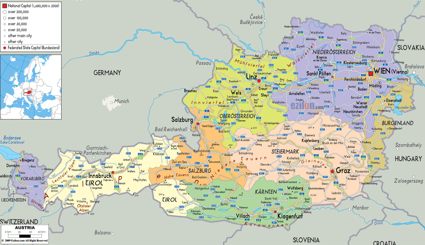
Description: Detailed large political map of Austria showing names of capital cities, towns, states, provinces and boundaries with neighbouring countries.

Map of Austria, Austria map with cities, major cities, and road network - this guide is written so you can follow our detailed map line by line. The Austria map with cities highlights all nine federal states, their capitals, border crossings, and the clean road links that tie the country together from Lake Constance in the west to the Pannonian plains near Hungary in the east. Because the map is the best political and transport view, it works for residents, travelers, and geography students who want to understand how Austria is arranged at a glance.
Austria is a landlocked country that lies in central Europe. You can find Germany and the Czech Republic to the North of the map, Slovakia and Hungary to the East, Slovenia and Italy to the South, and Switzerland and Liechtenstein to the West. Much of western and southern Austria is occupied by the Alps, while the Danube valley and lowlands extend across the north-east. The detailed map shows these contrasts by the way cities and roads cluster in valleys and plains and by how state boundaries follow mountain ridges and river lines.
If you look at the outline of Austria on the map, you notice an extended west-to-east stretch. Vorarlberg touches Lake Constance and the Swiss and German borders in the far west. Then the country runs through Tyrol, Salzburg, Upper Austria, Lower Austria, and Burgenland toward the Hungarian frontier. Carinthia and Styria form the southern flank against Slovenia and Italy, while Vienna stands slightly apart as a city-state surrounded by Lower Austria.
The Alps fill much of western Austria. Our Austria map with cities shows that the densest road network and the most important cities, such as Vienna, Graz, and Linz, are located in lower areas along the Danube and Mur rivers. Innsbruck, Salzburg, and Klagenfurt, located in narrower valleys, have fewer connecting roads between them. The detailed map helps explain why cross-country driving often follows curving valley routes and tunnels instead of straight lines.
Austria's neighbours are also clearly labelled, which is essential for trip planning. For example, it is evident on the map that Salzburg sits close to the German border, that Graz lies near Slovenia, and that Vienna is only a short distance from Slovakia and Hungary. This gives the map added value for travelers who want to combine Austria with surrounding countries in a single itinerary.
This Austria map with cities divides the country into nine states: Vorarlberg, Tyrol, Salzburg, Carinthia, Styria, Upper Austria, Lower Austria, Burgenland, and Vienna. Each state is shaded in a different colour, so boundaries are easy to see. State capitals such as Bregenz, Innsbruck, Salzburg, Klagenfurt, Graz, Linz, St. Pölten, Eisenstadt, and Vienna are designated as significant city symbols. Other important towns appear as smaller dots, usually along main roads or rivers.
The road network is drawn as clean lines, showing how key routes cross state borders. Highways and primary roads follow the Inn and Enns valleys, the Danube corridor, and cross Alpine passes to Italy and Germany. Even though road numbers may not be printed on the sheet, the pattern is clear enough for you to follow the principal transit axes while reading this description.
For residents, this detailed map is helpful because it sets their home state in a national context. For travelers, it is the best map reference, making it easy to see which cities can be visited together. For geography students, the combination of political boundaries, rivers, lakes, and road corridors turns the Austria map with cities into a compact classroom tool.
Starting on the far left of the map, you find Vorarlberg, Austria's westernmost state. It borders Switzerland, Liechtenstein, and Germany and faces Lake Constance in the northwest corner. The state capital, Bregenz, is marked on the lakeshore, with towns like Feldkirch, Bludenz, and Dornbirn also visible.
The road network shown in Vorarlberg follows narrow alpine valleys. One main route runs from Bregenz along the Rhine valley toward Switzerland, while another cuts through the Walgau and up toward the Arlberg region, linking into Tyrol. When you follow the roads on the map, you can see how Vorarlberg acts as a western gateway for traffic arriving from Switzerland and southern Germany.
According to our map the area east of Vorarlberg is Tyrol which you could easily think was North Tyrol and East Tyrol M placed respectively over the wreaths Salzburg and Carinthia. The Inn valley, where several road lines converge, is located in the capital, Innsbruck. Other villages located at crucial junctions of valleys and tourist hubs include Kufstein, Lienz, Imst, and Kitzbühel.
The detailed map shows how the Inn valley serves as a significant transport axis from Germany to Italy, crossing the Brenner Pass southward. You can trace the roads winding through side valleys leading to ski resorts and mountain passes, even if the resort names are not all printed. For geography students, Tyrol on the Austria map with cities is a textbook example of settlement in a longitudinal Alpine valley.
Continuing east, the next state is Salzburg, stretching from high mountains in the south to gentler hills near Germany in the north. The city of Salzburg itself sits close to the border, and on the map you can see road links running both east toward the rest of Austria and west into Bavaria.
The northern part of Salzburg state has lakes and rolling countryside, while the southern half is Alpine. The map shows towns like Zell am See or other regional centres placed along the central valley and lakeshore roads. This split geography, clearly visible on the map, explains why Salzburg is both a cultural capital and an outdoor sports hub.
To the northeast of Salzburg, you will see Upper Austria. Its capital, Linz, appears on the Danube River, near the point where roads from Germany and Salzburg meet the highway running toward Vienna. Other cities like Wels and Steyr are marked along side valleys and secondary corridors.
Upper Austria on the map bridges the gap between the Alps and the Bohemian Forest. You can see that the densest road network follows the Danube and the plains, while fewer connections cross the higher hills to the north. For residents and logistics planners, this layout shows how Upper Austria acts as an industrial heart connecting western Austria with the Czech Republic and the rest of Central Europe.
Near the eastern centre of the map, the city of Vienna is highlighted as both the national capital and a separate federal state. Vienna's symbol is larger than those of other cities, and several major roads and rail lines meet there. Because it sits on the Danube, Vienna has long been a key crossing point between western and eastern Europe.
When you trace the roads outward from Vienna on the Austria map with cities, you notice routes going west to Linz and Salzburg, north toward the Czech border, east toward Bratislava in Slovakia, and south toward Graz. This pattern makes it clear why Vienna is the country's transport hub as well as its cultural and political centre.
Surrounding Vienna on almost all sides is Lower Austria, the largest state by area. Its capital, St. Pölten, is located west of Vienna, close to the main highway and rail line along the Danube corridor. Other towns, such as Krems, Waidhofen an der Ybbs, or Wiener Neustadt, are shown in valleys and plains that ring the Alps and foothills.
Lower Austria stretches from the Bohemian Forest in the northwest to the March and Thaya rivers along the Czech and Slovak borders, and southward into the Vienna Basin. On our map, you can see how its shape wraps around Vienna, forming a transition belt between the Alpine and the lowland regions. For travelers, this means that wine villages, romantic river valleys, and medieval towns are all within easy reach of the capital.
South of Upper and Lower Austria lies Styria, often called the country's green heart. The map shows Graz, the state capital, located in a broad basin near the Slovenian border. Other towns such as Leoben, Kapfenberg, or Hartberg line the Mur and Mürz river valleys and their tributaries.
Styria on the detailed map appears as a large state that stretches from high mountains in the north to gentle hills in the southeast. Roads from Graz head north into the Alps, west toward Salzburg and Carinthia, and south into Slovenia. The pattern on the map helps explain why Graz is a major student city and economic centre with strong links to both Vienna and the Balkans.
To the southwest of Styria, you will find Carinthia, bordered by Italy and Slovenia. Its capital, Klagenfurt, is marked near Wörthersee, one of several lakes that stand out on the map. Other centres, like Villach, Spittal an der Drau, and Wolfsberg, lie along central river valleys and lake shores.
The detailed map shows roads entering Carinthia from Italy and Slovenia through Alpine passes and tunnels, then following the Drau valley toward Styria and Upper Austria. For travelers, this makes it easy to plan routes that combine lake holidays with mountain excursions and cross-border trips. For students, Carinthia illustrates how lake basins and river valleys serve as focal points for settlement in a high-mountain region.
On the far eastern side of the Austria map, with cities, you see Burgenland, a narrow state that runs from the Slovak border in the north to Slovenia in the south. Its capital, Eisenstadt, is located near the northern section, close to the famous Lake Neusiedl (Neusiedler See), which straddles the border with Hungary.
The map shows that Burgenland is mostly lowland and hill country, in contrast to the Alpine west. Roads along the frontier connect villages and small towns such as Rust, Neusiedl am See, and Oberwart, then link back toward Vienna and Graz. The map shows that historic borderlines, as well as modern cross-border cooperation, shape Burgenland, which stretches like a ribbon along Hungary.
For residents, this detailed map of Austria acts as a single frame that connects local knowledge to national geography. Someone in Innsbruck can easily point to Vienna, Graz, or Salzburg and show how the main roads and rail lines run. Businesses can use the map to explain logistics routes from Germany to Hungary or Italy to the Czech Republic.
For travelers, the Austria map with cities is a practical planning tool. You can pick out a state like Tyrol for mountain sports, Styria for wine and forests, or Vienna and Lower Austria for cultural routes along the Danube. Because state borders, major cities, lakes, and roads are all clearly shown, the map helps you design multi-day loops that use Austria's efficient rail and road system.
For geography students, the combination of political boundaries, relief hints, river lines, and transport corridors makes this one of the best map references for Central Europe. You can study how Alpine and lowland regions differ, how border states like Vorarlberg and Burgenland link Austria to its neighbours, and how a landlocked country builds strong connections in all directions.
By reading this long-form description while visually following the detailed map of Austria, you get a layered understanding of the country - from states and capitals down to river valleys, border strips, and road junctions.

Physical Map of Austria
Physical map and map image of Austria.

Road Map of Austria
Road map and map image of Austria.

Regional Directory of United States of America
Information and guide about United States of America and websites with American topics.

Regional Directory of Europe
Information and guide about Europe and websites with European topics.

Regional Directory of Australia
Information and guide about Australia and websites with Australian topics.