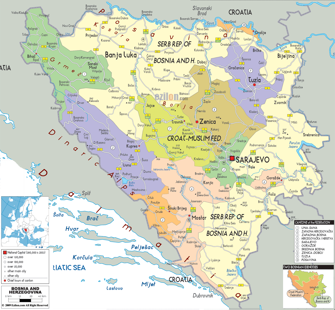
Description: Detailed large political map of Bosnia and Herzegovina showing names of capital cities, towns, states, provinces and boundaries with neighbouring countries.

Map of Bosnia and Herzegovina, Bosnia and Herzegovina map with cities, major cities, and road network are the core phrases this guide is built around. Our detailed map of Bosnia and Herzegovina shows the whole country in one frame, including the two entities, the Brčko District, every canton, major rivers, mountain chains, and the clean road links that connect Sarajevo, Banja Luka, Mostar, Tuzla, and dozens of smaller towns. This long explanation walks you through the sheet so residents, travelers, and geography students can follow the Bosnia and Herzegovina map with cities, as if we were tracing it together.
Bosnia and Herzegovina lies in the western Balkans, wedged between Croatia on most sides, Serbia to the east, and Montenegro to the southeast. The Adriatic Sea touches the country along a narrow coastal strip near Neum, which you can see at the lower left edge of the map. Inland, rugged Dinaric Alps ridges run parallel to the coast, while high plateaus and river valleys cut through the interior, as shown by the map's carefully shaped relief and winding river lines.
Our Bosnia and Herzegovina map with cities divides the country into its central political units:
Federation of Bosnia and Herzegovina (Croat-Muslim Fed.) - shaded in several pastel colours and subdivided into cantons.
Republika Srpska (Serb Rep. of Bosnia and Herzegovina) - stretching in two main arms across the north and east, shaded in contrasting tones.
Brčko District - a small but crucial neutral area in the northeast near the Sava River, singled out on the map.
In the lower-right inset labelled "Two Bosnian Entities", you see a simplified graphic that colours the Federation and Republika Srpska, helping users match the main sheet to the political structure. Another inset, "Cantons of the Federation", lists cantons such as Una-Sana, Posavina, Tuzla, Zenica-Doboj, Sarajevo, and Herzegovina-Neretva, with numbered symbols that appear on the main map.
The outer edges of our detailed map of Bosnia and Herzegovina clearly mark its neighbours. To the north, along the Sava River, you see Croatia, with towns like Slavonski Brod and Osijek just across the border. To the east and southeast lie Serbia and Montenegro, with names such as Užice, Priboj, Pljevlja, and Nikšić printed beyond the boundary. West and southwest, the Croatian coast and islands - Split, Dubrovnik, Brač, Hvar, Korčula, and Pelješac - are shown in the Adriatic Sea.
This border detail is vital for travel planning and for understanding how roads and rivers connect Bosnia and Herzegovina to the wider Balkans.
Near the centre-right of the map, you find Sarajevo, the national capital, highlighted with a red square symbol. It sits in a narrow valley surrounded by mountains, and the map shows roads climbing out in all directions: northwest toward Visoko and Zenica, west toward Kiseljak and Travnik, south toward Konjic and Mostar, and east toward Pale, Rogatica, and Foča.
The area around Sarajevo is labelled 'Sarajevo Canton' and coloured light green. Within this canton, smaller towns such as Ilidža, Hadžići, and Vogošća appear, showing how the urban region stretches along the Miljacka and Bosna river valleys. For residents and visitors, this part of the Bosnia and Herzegovina map with cities is essential for visualising how close mountain resorts, historical sites, and suburbs sit around the capital.
Zenica is a major industrial city located northwest of Sarajevo on the Bosna. The map shows it as a large dot on the main north-south road, the Multicoloured Heroes Canquest, that connects Sarajevo with Doboj and, further north, Banja Luka. The settlements along the river are clear from the nearby settlements. These include Kakanj town, Vareš, and Žepče.
Further west, you see Travnik, a historic town that once served as the Ottoman capital of Bosnia. Roads from Travnik cross mountain passes toward Jajce, Bugojno, and Donji Vakuf, all marked on our map. Geography students can see how the central highlands form a web of ridges and basins, influencing the placement of cities and the direction of roads.
In the northwest, coloured in pale yellow and cream, spreads a large portion of Republika Srpska. Its biggest city, Banja Luka, lies near the Vrbas River and is highlighted by a prominent city symbol. Roads from Banja Luka head north to Gradiška on the Sava, west to Prijedor, and east to Doboj, creating a strong triangle of regional centres.
The map shows other towns in northern Bosnia and Herzegovina, such as Bosanska Gradiška, Prnjavor, Kotor Varoš, and Bosanski Novi, each connected by clear road lines. Farther north, you see the Sava forming the boundary with Croatia, with border towns like Bosanski Brod, Brčko, and Bijeljina labelled on the Bosnian side.
Moving eastward along the Bosna valley, you reach Doboj, a cr tical crossroads. Our detailed map illustrates several highways meeting at Doboj, linking Banja Luka and Sarajevo with Tuzla and Bijeljina. Tuzla stands out in purple shading as a significant city in the Tuzla Canton of the Federation, though it is almost surrounded by territory of Republika Srpska.
Around Tuzla, towns such as Lukavac, Živinice, Banovići, and Kalesija are indicated, suggesting a densely populated industrial basin. Roads from Tuzla head toward Zvornik on the Drina River and toward Gračanica and Doboj in the Bosna valley, making this area one of the most complex junctions on the map of Bosnia and Herzegovina.
The Drina River makes a big bend in Serbia. It runs along the map's right flank. The river that winds through the towns of Zvornik and Goražde. The steepness of the valley slopes is shown by relief shading. At the same time, roads follow the riverbanks or scramble over passes to reach the interior towns, the most notable being Rogatica, Sokolac, and Pale.
For travelers using our map of Bosnia and Herzegovina to plan scenic drives, this Drina corridor is one of the most striking parts of the country, with deep gorges and historic bridges such as the one at Višegrad.
In the south-central section of the map, the label "Mostar" stands out in orange. Mostar is the central city of Herzegovina and lies within the Herzegovina-Neretva Canton. The Neretva River runs through Mostar from north to south, and the map shows roads following the valley toward Konjic and Jablanica in the north, and toward Čapljina and Metković near the Croatian border in the south.
Nearby towns such as Široki Brijeg, Ljubuški, Čitluk, and Prozor-Rama are also shown, revealing a network of smaller settlements around the central valley. Because the map emphasises both cantonal colours and key roads, you can easily understand how this region connects Mostar to Sarajevo and to the Adriatic coast.
West of Mostar and south of Jajce, the map highlights Livno, Tomislavgrad, and Kupres, situated on high plateaus of the Dinaric Alps. Roads from these towns lead toward Split on the Croatian coast, toward Bugojno, and toward Mostar, bridging inland Bosnia and Herzegovina with Dalmatia.
This illustration depicts Herzegovina's rugged mountains and character. This demonstrates to residents that road distances are longer than they appear on a straight-line map. For geography students, this is a good case study of how karst mountains alter transport corridors.
At the lower left edge of the main map, you will find Neum, Bosnia and Herzegovina's only coastal town on the Adriatic Sea. The coastline is short but strategically important, and the map places Neum between Croatian coastal segments that lead to Dubrovnik in the south and Split in the northwest. From Neum, roads climb inland toward Stolac and Mostar.
This tiny coastal strip is essential for travel planning, and its position stands out clearly on our detailed map of Bosnia and Herzegovina.
In the far northwest, along the border with Croatia, lies Una-Sana Canton, colored in green. The city of Bihać lies on the Una River, with roads leading to Cazin, Velika Kladuša, Bosanski Petrovac, and Bosanska Krupa. The map also shows nearby Croatian towns such as Slunj across the border.
The western edge is lined with mountain ridges labelled "Dinaric Alps", and the combination of river loops, international border, and hilly terrain makes this region a fascinating study of borderland geography.
Residents can use this Bosnia and Herzegovina map with cities to understand how their municipality fits into the entities, cantons, and districts. Someone living in Zenica can trace the main corridor to Sarajevo and Doboj. A resident of Bijeljina can see links to Tuzla, rčko, and Serbia. The map also makes it clear which parts belong to the Federation and Republika Srpska, which can be an essential point for administration and everyday life.
Travelers can use the detailed map to plan their road journeys. A regular journey might start in Sarajevo, go through Mostar and the Neretva valley, branch off into the highlands to Livno and Bihać, swing east towards Banja Luka and Tuzla, then follow the Drina valley southwards before returning to the capital. You will see driving times clearly marked on every significant road. And you will also notice alternative passes or a river route where applicable.
The Bosnia-Herzegovina map allows students to study a post-conflict federation with a settlement pattern dominated by rivers, forests, and mountains. The Sava plain is flat, the Dinaric Alps are high, while the Adriatic outlet is narrow. These are all interrelations (manifestations) in an area of both physical and political geography.

Physical Map of Bosnia and Herzegovina
Physical map and map image of Bosnia and Herzegovina.

Road Map of Bosnia and Herzegovina
Road map and map image of Bosnia and Herzegovina.

Regional Directory of United States of America
Information and guide about United States of America and websites with American topics.

Regional Directory of Europe
Information and guide about Europe and websites with European topics.

Regional Directory of Australia
Information and guide about Australia and websites with Australian topics.