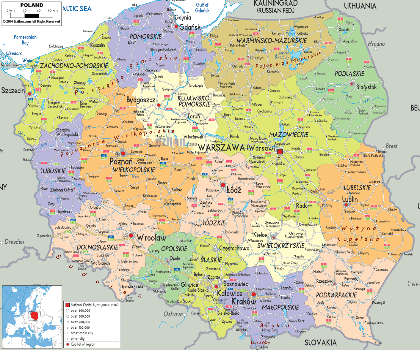
Description: Detailed large political map of Poland showing names of capital cities, towns, states, provinces and boundaries with neighbouring countries.
 When you first glance at the Political Map of Poland, it's impossible not to notice how the Poland political boundaries are drawn, each province - or voivodeship - outlined in distinct colors. This map of Poland with cities and provinces shows a country at the heart of Central Europe, bordered by Germany, the Czech Republic, Slovakia, Ukraine, Belarus, Lithuania, and the Baltic Sea to the north. The political divisions reflect a blend of history, culture, and geography, and every Polish administrative division tells its own story.
We'll begin at the northern coast along the Baltic Sea, then move southward into the country's core before traveling eastward, constantly referencing the landmarks, cities, and capitals as they appear on our map.
Looking at the Baltic Sea, the Polish coast, you'll see the Pomeranian Voivodeship outlined in a soft blue shade. At its heart is Gdańsk, one of the most historically significant Polish provincial capitals, marked boldly on the map. This is a key part of the Poland travel map for maritime tourism. Alongside Gdansk, the map reveals Gdynia and Sopot, forming the famous Tri-City area. The province's coastline is dotted with sandy beaches and ports, and to the west, Łeba and Ustka hug the shorelines.
Rivers like the Vistula spill into the Baltic here, something you can trace visually on the political map as a pale blue line cutting through the region before widening into the Gulf of Gdansk.
Traveling west along the coast on our map of Poland with cities, we reach West Pomeranian Voivodeship. The province's political outline is shaped around bays, islands, and peninsulas. Szczecin, its provincial capital, lies inland near the Poland-Germany border - marked on the map with a bold black line.
The province's coastline includes the ferry port at Świnoujście, which is important for Germany and Scandinavia. The Baltic Sea is an important travel and trade facility here; therefore, this is one of the features that may catch the attention of geography students and travellers who choose to travel to Poland's coastal cities.
Moving eastward from Gdańsk, the political boundaries shift inland to the lake district of Warmian-Masurian Voivodeship. On the map, you'll notice this region dotted with numerous small blue patches - each a lake in the Masurian Lake District. Olsztyn, the provincial capital, sits centrally, surrounded by green fields and waterways.
This is one of the most striking parts of the Polish political map due to its sheer number of water bodies, which are clearly labeled and shaded. To the north, the map shows the proximity to the Poland and Russia border (Kaliningrad Oblast), giving the province geopolitical importance.
Heading south from Gdańsk along the Vistula on our Poland country borders map, we reach Kuyavian-Pomeranian Voivodeship, unique for having two capitals: Bydgoszcz and Toruń. The map marks both with equal prominence, illustrating their administrative duality. Toruń, visible just east of the river, is a UNESCO World Heritage Site, while Bydgoszcz stands as an industrial hub.
This region serves as a bridge between coastal provinces and central Poland, as evident from its location on the administrative divisions layout of Poland.
Turning our gaze to the northeast corner of the Poland political boundaries, Podlaskie Voivodeship borders Lithuania and Belarus - both shown on the map with dotted international borders. Its capital, Białystok, is positioned near the center, surrounded by lush green zones representing forests and national parks.
Podlasie is the only region in Poland that provides proper cross-border transit through Belarus. The low density of the population means there are relatively few urban dots on the political map, but because of its position at the border, the area will certainly be of importance in border discussions with Poland.
At the center of the Polish political map is Masovian Voivodeship, dominated by Warsaw, the national capital, marked with a special star icon. From here, political influence radiates outward. The Polish provincial capitals marking for Warsaw stands out due to its size and location along the Vistula River.
This region connects directly to nearly all neighboring provinces, which is easy to trace by following the network of connecting lines on the map. Radom, Płock, and Siedlce also appear, each playing a role in the province's urban network.
Just southwest of Warsaw, the Łódź Voivodeship is centered around Łódź, marked prominently for its industrial heritage. On the map of Poland with cities, it's almost equidistant from Warsaw and Poznan, highlighting its central role in trade routes. The map shows well-connected transport lines radiating from the town, signifying its logistical importance.
On the Poland provinces map, the Pomeranian Voivodeship dominates the northern Baltic coastline. Its capital, Gdańsk, is clearly labeled and sits at the mouth of the Motława River, opening into the Bay of Gdańsk. Alongside Gdynia and Sopot, it forms the famous Tri-City metropolitan area — a cluster of Spanish coastal cities–style port towns that serve as key hubs for shipping, tourism, and culture.
Looking closely at the Polish political boundaries, you can see how Pomerania stretches inland to include cities like Słupsk, Chojnice, and Starogard Gdański, each plotted along major road and rail lines. For anyone studying political geography, this province is a perfect example of coastal economic integration.
East of Pomerania lies Warmian-Masurian Voivodeship, one of the most distinctive regions on the Poland administrative divisions map due to its abundance of lakes and green spaces. Olsztyn, the provincial capital, sits at the heart of the Masurian Lake District, an area renowned for sailing and water tourism — an equivalent in spirit to Balearic Islands travel guide appeal, though far inland.
The map of Poland with cities and provinces shows other towns like Ełk, Giżycko, and Mrągowo, scattered among blue patches marking the lakes. This area's location, bordering Russia's Kaliningrad Oblast, is critical for understanding Poland's country borders in the northeast.
Swinging westward on the Iberian Peninsula map-style layout of Poland, West Pomeranian Voivodeship hugs the Baltic Sea from the German border to Koszalin. Its capital, Szczecin, is located inland along the Oder River, yet remains a major seaport thanks to its deepwater connections.
The Spain travel map–style benefit here is the mix of sandy beaches and urban centers like Świnoujście, Kołobrzeg, and Stargard, all marked clearly on the Poland political features legend.
On the map of Poland's political boundaries, you'll see Kuyavian-Pomeranian Voivodeship distinguished by its unique arrangement: it has two capitals — Bydgoszcz and Toruń, both equally important. This unusual setup is rare among Spain's regions and provinces equivalents.
Bydgoszcz is marked along the Brda and Vistula rivers, while Toruń, further downstream, is known for its medieval architecture. Other cities, such as Wloclawek and Inowroclaw, appear southward, forming a transport hub visible on the Polish road and political map.
Moving south into Łódź Voivodeship, the map highlights Łódź prominently as a central Polish industrial and cultural hub. Its position in the Spain provincial breakdown equivalent is like Madrid's — central and influential, without being the political capital.
The Poland political map shows satellite cities like Piotrków Trybunalski, Zgierz, and Bełchatów, all feeding into Łódź's economic orbit.
The Podlaskie region sits at the northeast edge, connecting Poland's country borders with Lithuania and Belarus. The political boundaries outlined here are critical for understanding Eastern European geopolitics.
Białystok, its capital, is marked as the largest city in the area. Around the same time, the compact towns of Augustów and Suwałki near crystal-clear lakes and forests, are a star on the Poland travel map and a nature escape for those after a travel-style holiday.
By exploring the Poland political map province-by-province, we've integrated key Poland political features and Spain travel map–style tourism notes into a single, seamless narrative.
From the Poland and Germany border in the west, through the Poland and Belarus frontier, and down to the Poland and Slovakia boundary, each voivodeship offers distinct identity markers - visible right on the map - that help both geography students and travelers grasp the structure of Poland's administrative divisions.
Whether your interest is in the coastal ports of Pomeranian Voivodeship, the industrial hubs of Silesian Voivodeship, or the mountainous borderlands of Lesser Poland, the province-by-province guide to Poland is your key to both academic understanding and cultural exploration.

Physical Map of Poland
Physical map and map image of Poland.

Road Map of Poland
Road map and map image of Poland.

Regional Directory of United States of America
Information and guide about United States of America and websites with American topics.

Regional Directory of Europe
Information and guide about Europe and websites with European topics.

Regional Directory of Australia
Information and guide about Australia and websites with Australian topics.