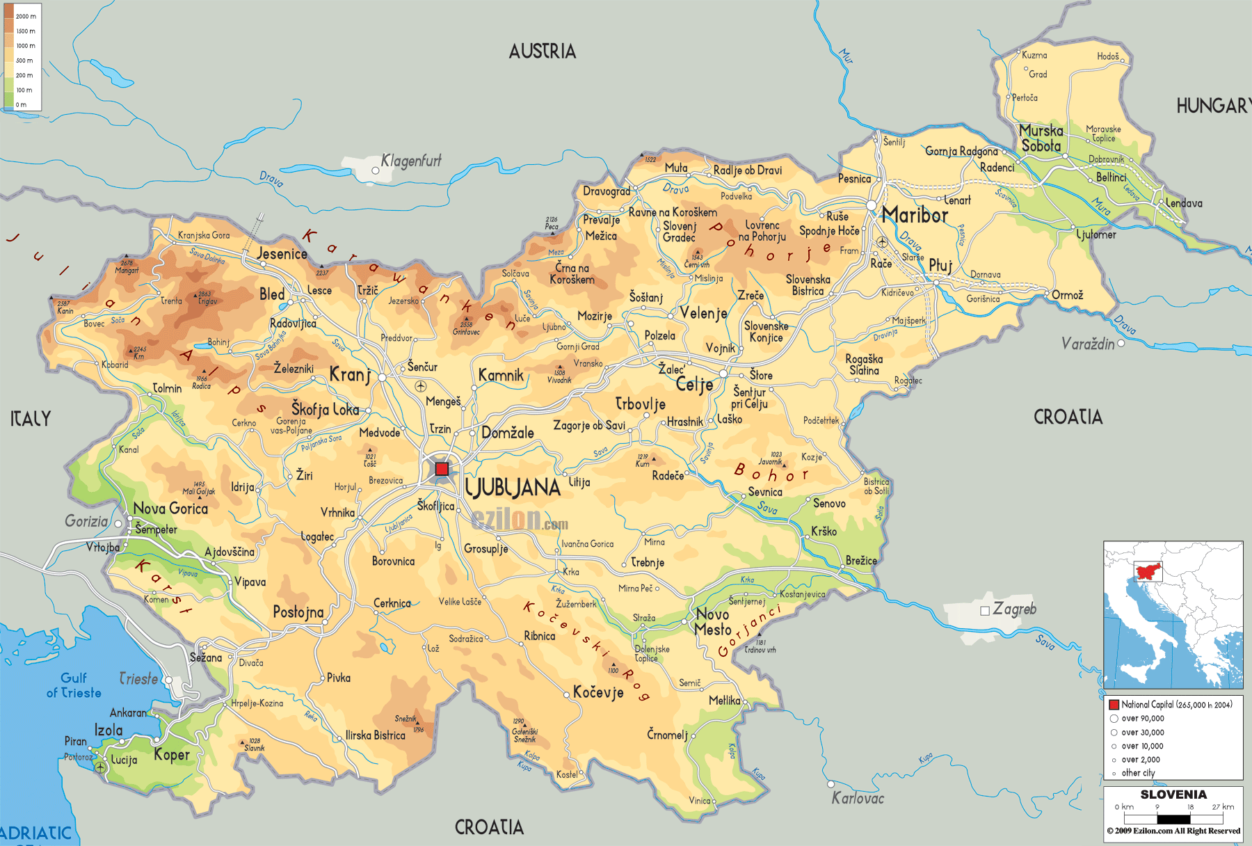
Description: The Physical Map of Slovenia showing major geographical features like elevations, mountain ranges, seas, lakes, plateaus, peninsulas, rivers, plains, landforms and other topographic features.
 Slovenia
with the official name as the Republic of Slovenia is a
nation state on the Adriatic Sea. It is surrounded by
Croatia to the south and southeast, Austria to the
north, Hungary to the northeast, and Italy to the west.
Slovenia
with the official name as the Republic of Slovenia is a
nation state on the Adriatic Sea. It is surrounded by
Croatia to the south and southeast, Austria to the
north, Hungary to the northeast, and Italy to the west.
20,273 square kilometres is the area Slovenia covers.
Forty seven kilometre is the approximate length of the
Adriatic coastline. It runs from Croatia to Italy.
Slovenia touches the Alps and borders the Mediterranean
and is situated in central Europe Triglav at 2,864 m is
the highest peak in Slovenia.
The Alps, the Dinarides, the Pannonian Plain, and the
Mediterranean are the four main regions and they meet in
Slovenia. The Kamnik-Savinja Alps, the Julian Alps, the
Karavanke chain are in the north part of Slovenia.
Kras Plateau in Slovenia is a limestone region and
features underground gorges, caves and rivers.
Slovenia’s most of the terrain is hilly. East and
northeast part is generally flat.
Slovenia is the third most forested country in the
Europe as half of the country is covered by forests
only. The river system is divided into two parts, Black
Sea basin and Adriatic Sea basin. As most of the
Slovenia is based in Adriatic basin, it is the main
drainage basin.

Political Map of Slovenia
Political map and map image of Slovenia.

Road Map of Slovenia
Road map and map image of Slovenia.

Regional Directory of United States of America
Information and guide about United States of America and websites with American topics.

Regional Directory of Europe
Information and guide about Europe and websites with European topics.

Regional Directory of Australia
Information and guide about Australia and websites with Australian topics.