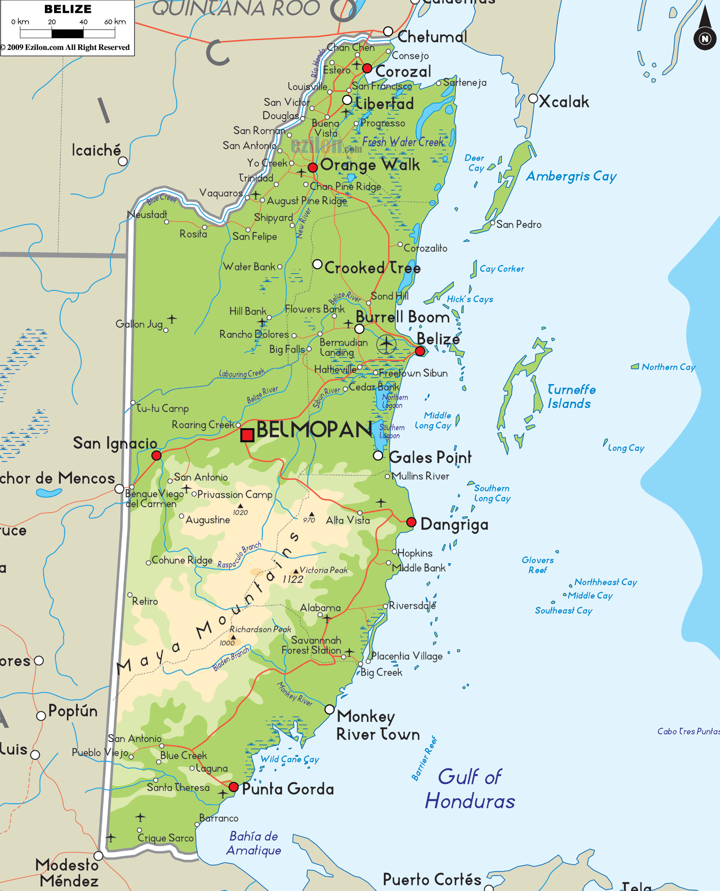
Description: The Physical Map of Belize showing major geographical features like elevations, mountain ranges, ocean, plateaus, peninsulas, rivers, plains, landforms and other topographic features.
 Belize
is a country situated in Central America on the Yucatan
Peninsula. The country is bordered by the Caribbean Sea
to the east with a 386 kilometer long coastline. The
country has a total area of 22,960 square kilometers out
of which 22,800 square kilometer is land and 160 square
kilometers is water. The country lies between 17 degrees
north latitude and 88 degrees west longitude. The
country is surrounded by many islands and coral reefs.
The Belize Barrier Reef is the longest reef in the
western hemisphere.
Belize
is a country situated in Central America on the Yucatan
Peninsula. The country is bordered by the Caribbean Sea
to the east with a 386 kilometer long coastline. The
country has a total area of 22,960 square kilometers out
of which 22,800 square kilometer is land and 160 square
kilometers is water. The country lies between 17 degrees
north latitude and 88 degrees west longitude. The
country is surrounded by many islands and coral reefs.
The Belize Barrier Reef is the longest reef in the
western hemisphere.
The climate of the country is generally tropical with
two distinct hot and rainy seasons. The terrain is
dominated by a swampy coastal plain and low lying
mountains to the south. The highest point on the
mainland is called Victoria Peak as it rests at 1,122
meters. The lowest point rests at mean sea level.
The southern part of the country is taken up by the
Cockscomb and Maya Mountain Range and their basins. The
north is watered by many rivers and streams of which the
Belize River is the longest as it flows for 290
kilometers. The Chetumal Bay lines the northern border.
The other important rivers include the Sibun, Hondo and
Monkey rivers.

Political Map of Belize
Political map and map image of Belize.

Regional Directory of Caribbean
Information and guide about Caribbean and website listing.

Regional Directory of United States of America
Information and guide about United States of America and websites with American topics.

Regional Directory of Europe
Information and guide about Europe and websites with European topics.

Regional Directory of Australia
Information and guide about Australia and websites with Australian topics.