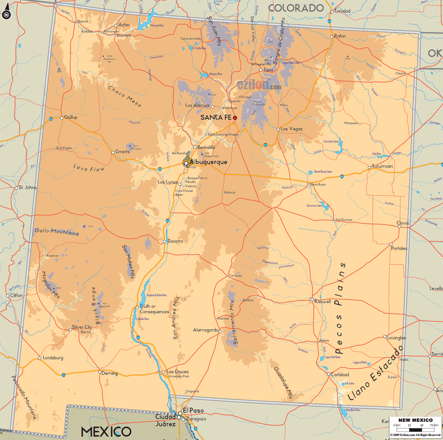

Description: The Physical map of New Mexico State, USA showing major geographical features such as rivers, lakes, topography and land formations.
 Introduction:
Embarking on a geographical journey through the heart of the American southwest, we have a breathtaking pause at the state of New Mexico. Rich in cultural history and graced by a unique blend of topographies, this state is prominent in the United States geographical narrative. The Large Detailed Physical Map of New Mexico aims to encapsulate the physical essence of this diverse state.
A comprehensive depiction of the land's topography, including rivers, lakes, mountains, hills, and other natural elements, becomes apparent with a simple glance. The map is further demarcated into South, North, East, West, and Central areas to offer a well-structured and elaborate elucidation of the geographical marvels that lie in each sector.
This account will walk you through the diverse segments and clarify the map's significance, clearly understanding New Mexico's exceptional ecological setting.
As illustrated in the map, the southern stretch of New Mexico is a canvas of remarkable geological tapestries. Standing tall amidst this region are the Guadalupe Mountains, whose rugged contours seamlessly extend into Texas. The map effortlessly captures the bold essence of these mountains, delineating their ridges and valleys with impeccable precision. The hues employed across this terrain in the map reflect the stark transition from a desert to a semi-arid climate, narrating the region's climatic tale visually appealingly.
The cartographic presentation of the Rio Grande is noteworthy as it meanders through the expansive arid zones, symbolizing a lifeline in a land of parched elegance. Various water bodies, including the Brantley Lake, are mapped with a discerning eye, depicting them as modest reservoirs amidst dry land. The meticulous illustration of smaller lakes and ponds serves as geographical annotations to the area's hydrological profile, each water body seemingly whispering tales of survival in a harsh climate.
Going in a northern direction on the map will lead you to the marvelous Sangre de Cristo Mountains. It is the southernmost subrange of the Rocky Mountains, emphasized by their towering peaks and steep ridges, as presented in the map. The captivating ski resorts like the Taos Ski Valley, nestled amidst these majestic mountains, make a quaint appearance on the map, acting as gateways to adventure in this high-altitude haven.
The expansive Carson National Forest is another prominent feature in this sector, its sprawling greenery a soothing sight on the map amidst the overarching arid theme of the state. The map embellishes the north's hydrological aspects by depicting the Rio Grande's continuous flow alongside rivers like the Chama and San Juan. The rivers function as significant channels through which the land obtains nutrients, much like veins in our bodies.
The eastern sector unfolds a predominantly flat or gently rolling terrain, marking the edge of the Great Plains. The map captures this transition with a subtle shift in color palettes, signifying a gradual move into a more arid zone. Townships like Clovis and Portales emerge as significant landmarks in this region on the map, marking human settlements amidst the sprawling plains.
With its snaking course through the plains before crossing into Texas, the Pecos River is a significant highlight. Its detailed portrayal on the map accentuates the river's vital role in shaping the region's geographical and ecological narrative. The map's color gradations around this river hint at the moisture it lends to the adjoining areas.
As one pivots westward on the map, the contrasting terrains of New Mexico continue to astound. The Zuni Mountains make a compelling appearance, their wooded expanses contrasting the surrounding arid domain. The map masterfully captures this green oasis, picturing dense woodlands nestling amidst dry landscapes.
The map further unveils the enigmatic El Malpais National Monument, a realm of unique volcanic fields. The ruggedness of this region, marked by ancient lava flows and cinder cones, echoes through the map's detailed depiction. The contrast between the rocky formations and sparse vegetation is visually articulated on the map, portraying a tale of survival and adaptation.
Central New Mexico is a geographical epicenter where diverse topographies converge. The map meticulously outlines the vast expanses of the Cibola National Forest, a verdant enclave amidst a desert-dominated backdrop. The Rio Grande, coursing through Albuquerque and bisecting the region into eastern and western halves, emerges as a focal point in the map, signifying the region's hydrological richness.
The map delves into an articulate delineation of the Manzano and Sandia Mountains, offering a dimensional view of the region's elevation variances. These ranges are presented with a varying color spectrum on the map, visually representing the different altitude levels. The map encapsulates the undulating nature of the terrain, providing viewers with a taste of the region's mountainous charm.
In geographical explorations, the Large, Detailed Physical Map of New Mexico is a meticulously crafted document inviting viewers to a profound visual journey across New Mexico's vast expanses.
Each section, be it North, South, East, West, or Central, unearths a distinct topographical narrative. The map provides a holistic view of New Mexico's diverse physical landscape, from the arid stretches to lush woodlands, towering peaks to serene plains, and the life-giving rivers to tranquil lakes.
Through a detailed portrayal of each river, mountain, lake, and significant land formation, this map transcends mere cartographic lines to offer a comprehensive geographical story, enhancing the viewer's understanding and appreciation of New Mexico's unique physical geography.

Counties and Road Map of New Mexico
Counties and Road map and map image of New Mexico.

Regional Directory of Canada
Information and guide about Canada and website listing.

Regional Directory of United States of America
Information and guide about United States of America and websites with American topics.

Regional Directory of Europe
Information and guide about Europe and websites with European topics.

Regional Directory of Australia
Information and guide about Australia and websites with Australian topics.