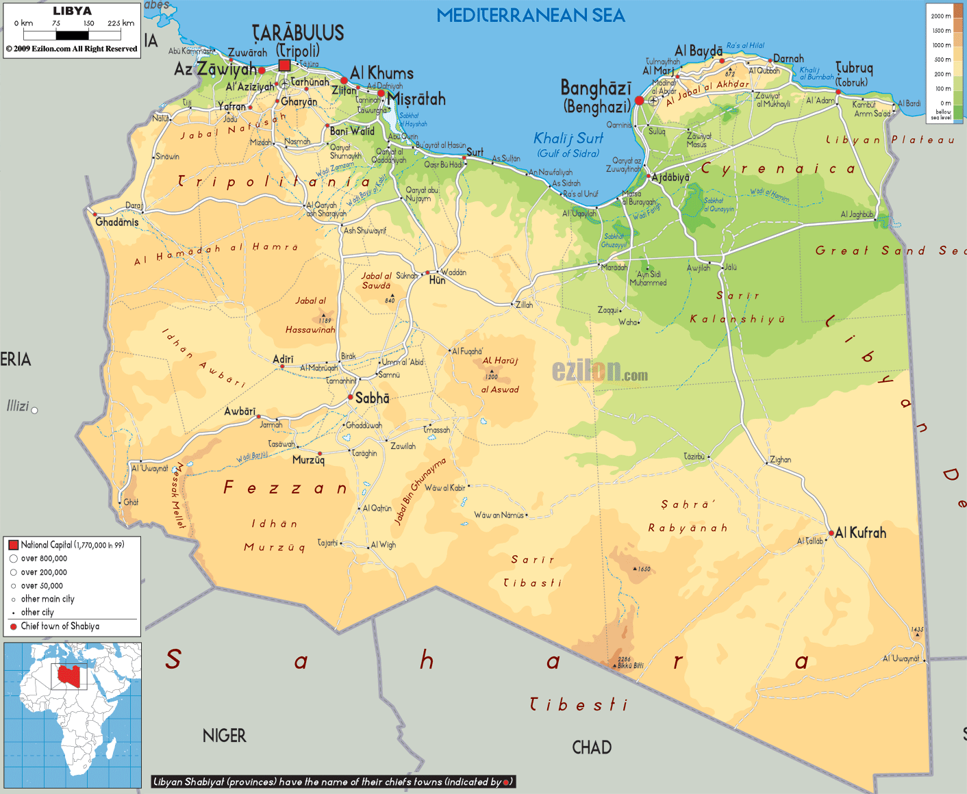
Description: The Physical Map of Libya showing major geographical features like elevations, mountain ranges, deserts, seas, lakes, plateaus, peninsulas, rivers, plains, landforms and other topographic features.
 Libya,
officially known as the State of Libya is located in the
Maghreb region of North Africa and touches the
Mediterranean Sea in the north. It has Egypt toits east,
Sudan to its southeast, Niger and Chad to its south,
Tunisia and Algeria to its west. It covers an area of
about 2 million square kilometres and is proclaimed as
the 4thlargest country in Africa.
Libya,
officially known as the State of Libya is located in the
Maghreb region of North Africa and touches the
Mediterranean Sea in the north. It has Egypt toits east,
Sudan to its southeast, Niger and Chad to its south,
Tunisia and Algeria to its west. It covers an area of
about 2 million square kilometres and is proclaimed as
the 4thlargest country in Africa.
At 1,800 kilometres, Libya has the longest coastline in
the African continent, facing the Mediterranean Sea. A
portion of Mediterranean Sea to the north of Libya is
referred to as the Libyan Sea.
There are a few scattered uninhabited small oases,
usually linked to the major depressions, where water can
be found by digging to a few feet in depth. In the west
there is a widely dispersed group of oases in
unconnected shallow depressions, the Kufra group,
consisting of Tazerbo, Rebianae and Kufra.
Slightly further to the south are the massifs of Arkenu,
Uweinat and Kissu. These granite mountains are ancient,
having formed long before the sandstones surrounding
them. Arkenu and Western Uweinat are ring complexes very
similar to those in the Aïr Mountains. Eastern Uweinat
(the highest point in the Libyan Desert) is a raised
sandstone plateau adjacent to the granite part further
west.
The plain to the north of Uweinat is dotted with eroded
volcanic features. With the discovery of oil in the
1950s also came the discovery of a massive aquifer
underneath much of the country. The water in this
aquifer pre-dates the last ice ages and the Sahara
desert itself. This area also contains the Arkenu
structures, which were once thought to be two impact
craters.

Political Map of Libya
Political map and map image of Libya.

Road Map of Libya
Road map and map image of Libya.

Regional Directory of United States of America
Information and guide about United States of America and websites with American topics.

Regional Directory of Europe
Information and guide about Europe and websites with European topics.

Regional Directory of Australia
Information and guide about Australia and websites with Australian topics.