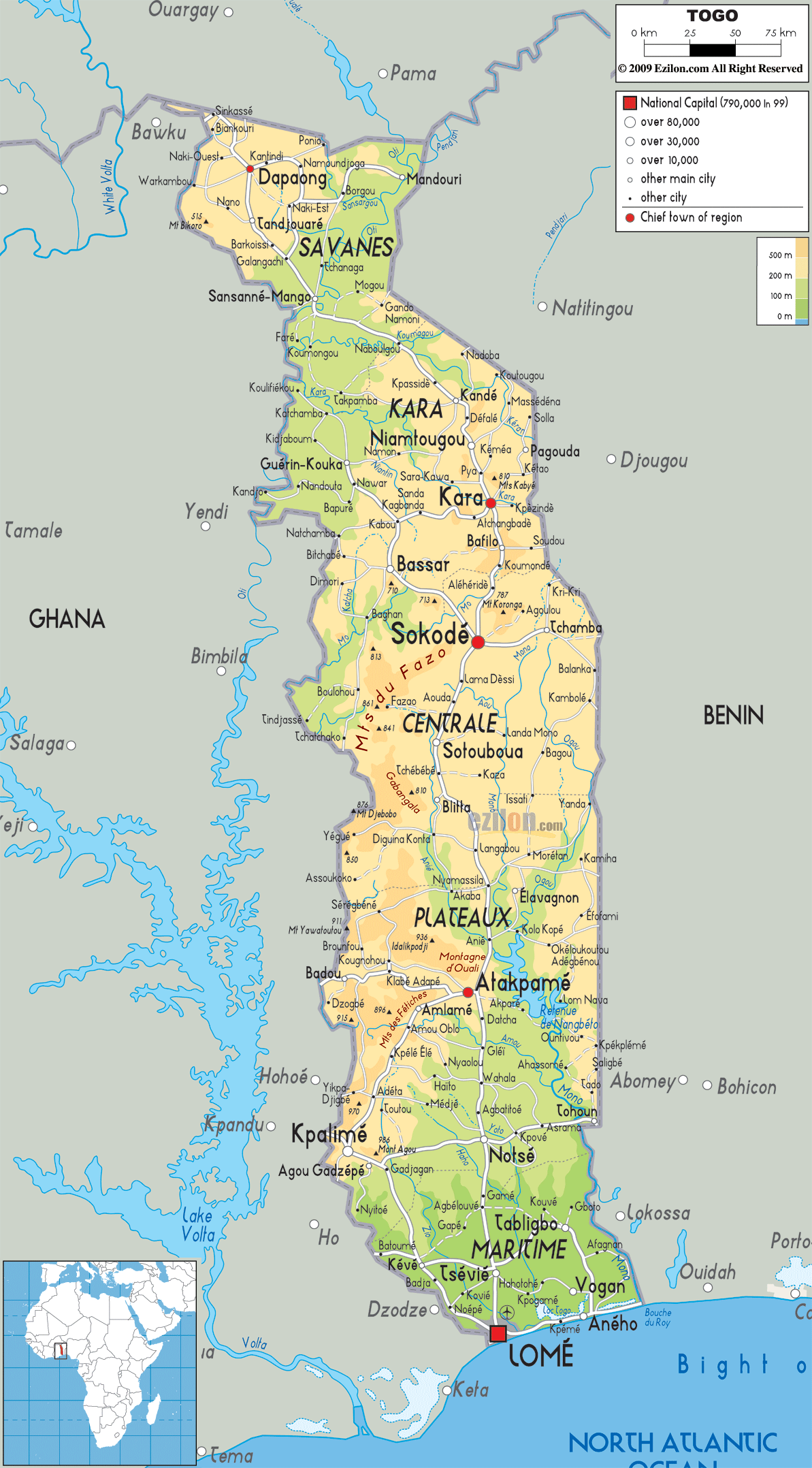
Description: The Physical Map of Togo showing major geographical features like elevations, mountain ranges, deserts, lakes, plateaus, peninsulas, rivers, plains, landforms and other topographic features.
This map of Togo with mountains, hills, lakes, rivers and other terrains is already large enough to read directly on your desktop. To see a full-screen zoom view on a phone or tablet, tap the map image (or tap the Zoom Map label above the image). Scan by shading regions in various colored blocks, with Togo's mountains, hills, lakes and rivers in bold.
 Togo
is a country in the West Africa and is officially called
the Togolese Republic. It is bordered by the Ghana on
the west, the Benin on the east and the Burkina Faso on
the north. It then extends towards south to Gulf of
Guinea. Togo covers a total area of about 57,000 square
kilometres. It is a tropical, sub-Saharan country which
is highly dependent on agriculture and has a climate
that is beneficial for good crop production.
Togo
is a country in the West Africa and is officially called
the Togolese Republic. It is bordered by the Ghana on
the west, the Benin on the east and the Burkina Faso on
the north. It then extends towards south to Gulf of
Guinea. Togo covers a total area of about 57,000 square
kilometres. It is a tropical, sub-Saharan country which
is highly dependent on agriculture and has a climate
that is beneficial for good crop production.
In the north the land consists of a gentlerolling
savanna as compared to the central parts of the country,
which consist of hills. The southern Togo consists of a
savanna as well as a forested plateau which extends to
meet the coastal plain full of extensive marshes and
lagoons. The land size of the country is about 56,800
km2.

Political Map of Togo
Political map and map image of Togo.

Road Map of Togo
Road map and map image of Togo.

Regional Directory of United States of America
Information and guide about United States of America and websites with American topics.

Regional Directory of Europe
Information and guide about Europe and websites with European topics.

Regional Directory of Australia
Information and guide about Australia and websites with Australian topics.