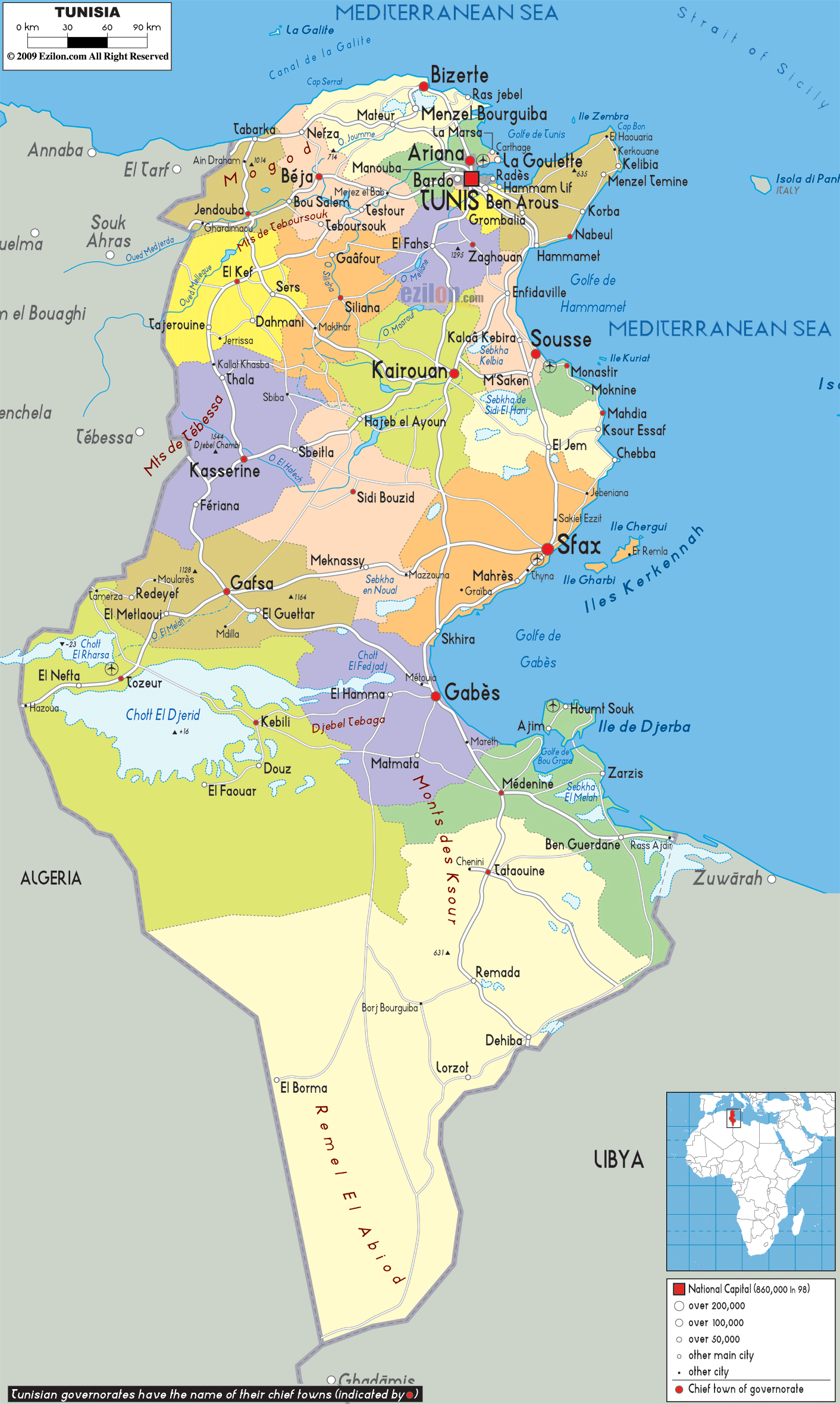
Detailed map of Tunisia with cities, towns, governorates, villages and surrounding countries. Tunisia shares its borders with Algeria and Libya.
This map of Tunisia with cities, governorates, and towns is already large enough to read directly on your desktop. To see a full-screen zoom view on a phone or tablet, tap the map image (or tap the Zoom Map label above the image). Scan by shading governorates in various colored blocks, with Tunisia's cities and towns in bold.
 Tunisia
is a country that lies in the north of Africa. On the
southeast of the country there is Libya and on the west
of Tunisia there is Algeria. Tunisia is situated on the
south of Sardinia and on the southwest of Sicily. The
size of the country is about 165,000 square kilometers
and it has a population of about 10,300,000 people. The
capital city of the country is Tunis. Tunisia is the
smallest country that is located along the Atlas
mountain range and it is the northernmost nation in
Africa. The Sahara Desert constituent about 40% of the
country of Tunisia and the remaining portion of the
country consists of coastline and fertile soil.
Tunisia
is a country that lies in the north of Africa. On the
southeast of the country there is Libya and on the west
of Tunisia there is Algeria. Tunisia is situated on the
south of Sardinia and on the southwest of Sicily. The
size of the country is about 165,000 square kilometers
and it has a population of about 10,300,000 people. The
capital city of the country is Tunis. Tunisia is the
smallest country that is located along the Atlas
mountain range and it is the northernmost nation in
Africa. The Sahara Desert constituent about 40% of the
country of Tunisia and the remaining portion of the
country consists of coastline and fertile soil.
The people from Tunisia are called Tunisians.

Physical Map of Tunisia
Physical map and map image of Tunisia.

Road Map of Tunisia
Road map and map image of Tunisia.

Regional Directory of United States of America
Information and guide about United States of America and websites with American topics.

Regional Directory of Europe
Information and guide about Europe and websites with European topics.

Regional Directory of Australia
Information and guide about Australia and websites with Australian topics.