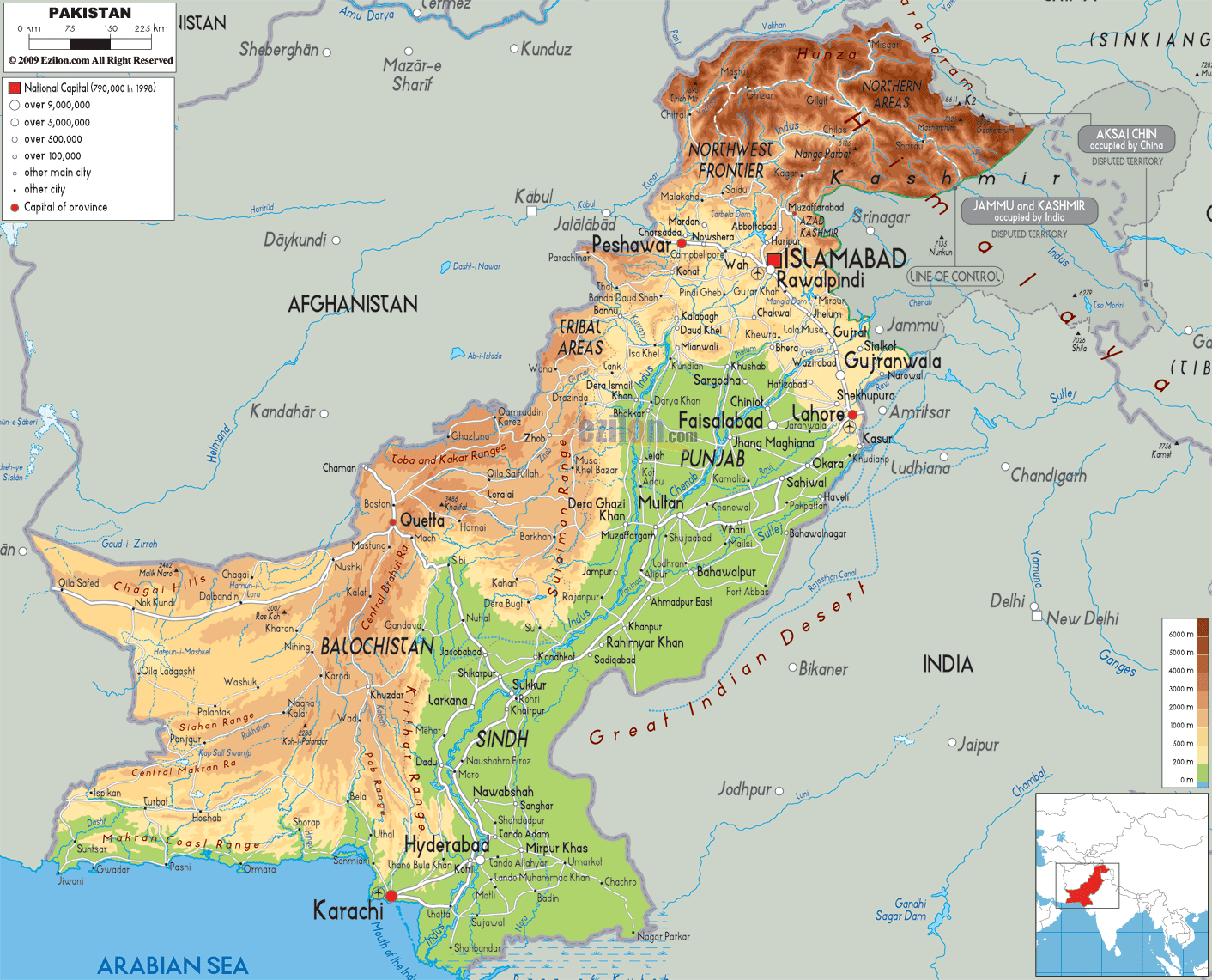
Description: The Physical Map of Pakistan showing major geographical features like elevations, mountain ranges, deserts, seas, lakes, plateaus, peninsulas, rivers, plains, landforms and other topographic features.
This map of Pakistan with mountains, hills, lakes, rivers and other terrains is already large enough to read directly on your desktop. To see a full-screen zoom view on a phone or tablet, tap the map image (or tap the Zoom Map label above the image). Scan by shading provinces in various colored blocks, with Pakistan's mountains, hills, lakes and rivers in bold.
 Pakistan
Detailed Physical map of Pakistan showing the Himalayas and Karakoram Mountains, the Indus River and deserts, elevations and other topographic features. Pakistan's physical landscape is shaped by its neighbors China to the northeast, India to the east, and Iran and Afghanistan to the west. Pakistan officially is called the Islamic Republic of Pakistan. 796,095 square kilometres
is the total area of Pakistan. In terms of area Pakistan
holds the 36th rank in the world. 1,046-kilometre is the
total length of the coastline which it shares with Gulf
of Oman in the south and the Arabian Sea.
Pakistan
Detailed Physical map of Pakistan showing the Himalayas and Karakoram Mountains, the Indus River and deserts, elevations and other topographic features. Pakistan's physical landscape is shaped by its neighbors China to the northeast, India to the east, and Iran and Afghanistan to the west. Pakistan officially is called the Islamic Republic of Pakistan. 796,095 square kilometres
is the total area of Pakistan. In terms of area Pakistan
holds the 36th rank in the world. 1,046-kilometre is the
total length of the coastline which it shares with Gulf
of Oman in the south and the Arabian Sea.
Its bordering countries are Iran to the southwest, India
to the east, China in the far northeast and Afghanistan
to the west. Wakhan Corridor in the north of the
Afghanistan is the separation boundary between Pakistan
and Tajikistan. It also has a water border with Oman.
Azad Kashmir and Gilgit–Baltistan are on the frequent
earthquake zone area because they are situated at the
edge of the Indian plate. Hindu Kush, Karakoram and
Pamir are the main mountain ranges and contains some of
the highest mountains in the world. K2 at 8,611 metres
is the second highest peak in the world and is in
Pakistan. It also has Thar Desert in the east.

Political Map of Pakistan
Political map and map image of Pakistan.

Road Map of Pakistan
Road map and map image of Pakistan.

Regional Directory of United States of America
Information and guide about United States of America and websites with American topics.

Regional Directory of Europe
Information and guide about Europe and websites with European topics.

Regional Directory of Australia
Information and guide about Australia and websites with Australian topics.
