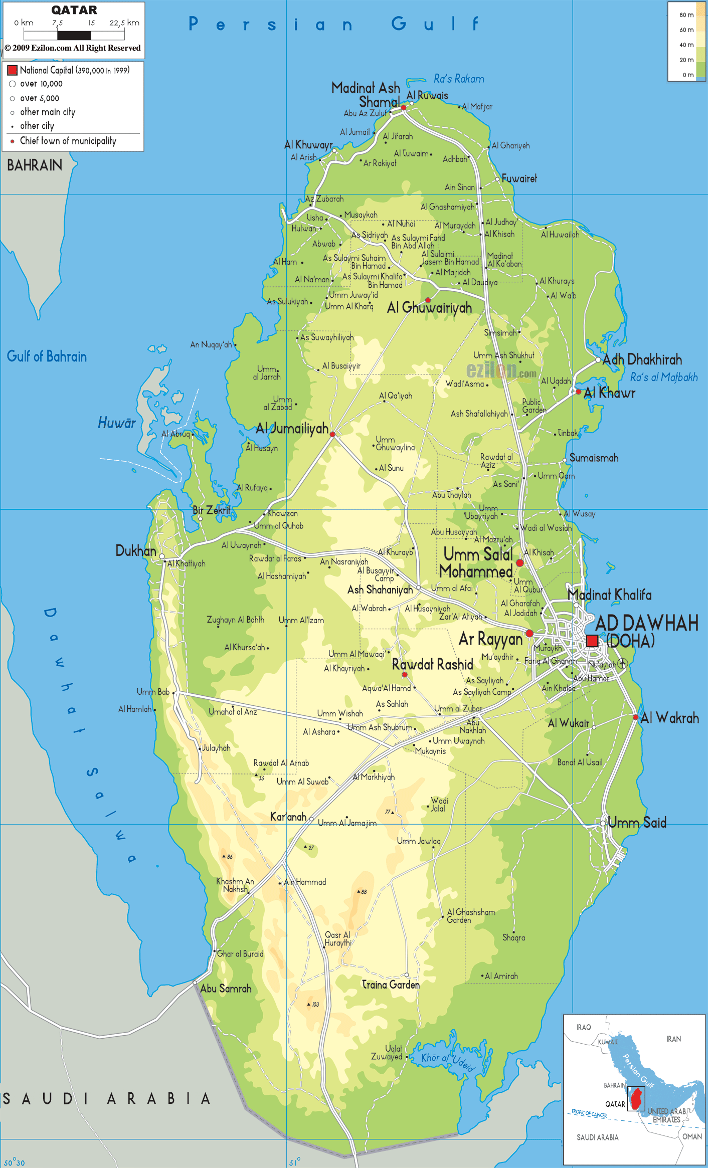
Description: The Physical Map of Qatar showing major geographical features like elevations, mountain ranges, deserts, seas, lakes, plateaus, peninsulas, rivers, plains, landforms and other topographic features.
This map of Qatar with mountains, hills, lakes, rivers and other terrains is already large enough to read directly on your desktop. To see a full-screen zoom view on a phone or tablet, tap the map image (or tap the Zoom Map label above the image). Scan by shading municipalities in various colored blocks, with Qatar's mountains, hills, lakes and rivers in bold.
 Detailed Physical map of Qatar showing flat desert and coastline, elevations and other topographic features. Qatar shares its only land border with Saudi Arabia to the south, and is otherwise surrounded by the Gulf of
Persia. It is separated from kingdom of Bahrain by a
strait in the Persian Gulf.
Detailed Physical map of Qatar showing flat desert and coastline, elevations and other topographic features. Qatar shares its only land border with Saudi Arabia to the south, and is otherwise surrounded by the Gulf of
Persia. It is separated from kingdom of Bahrain by a
strait in the Persian Gulf.
The topography of Qatar consists mostly of barren plain with lowlands and it is covered with sand. Surrounding an inlet of the Persian Gulf there is an area of rolling sand dunes the Khor al Adaid to the southeast in the country. Qurayn Abu al Bawl at 103 metres is the highest point of the country. It is located to the west inthe Jebel Dukhan.
A range of low limestone outcroppings which runs from
north-south diection from Zikrit to the southern border
is the feature of this range. Qatar's main onshore oil
deposits are located in the Jebel Dukhan area. To the
northwest of the country lie the natural gas resources.
It holds very great significance because of its
resources of the natural gas. 142 fungal species are
found in Qatar. The highest per-capita carbon dioxide
emissions are produced by Qatar in the world.

Political Map of Qatar
Political map and map image of Qatar.

Road Map of Qatar
Road map and map image of Qatar.

Regional Directory of United States of America
Information and guide about United States of America and websites with American topics.

Regional Directory of Europe
Information and guide about Europe and websites with European topics.

Regional Directory of Australia
Information and guide about Australia and websites with Australian topics.