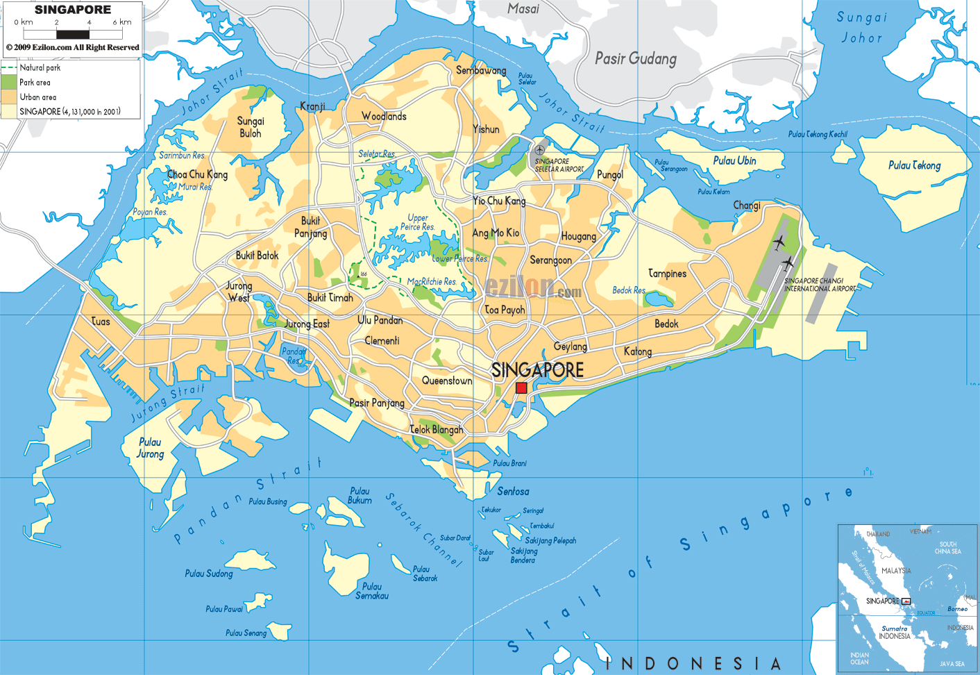
Description: Detailed large political map of Singapore showing names of capital city, towns, states, provinces and boundaries with neighbouring countries.
This map of Singapore with cities, planning areas, and towns is already large enough to read directly on your desktop. To see a full-screen zoom view on a phone or tablet, tap the map image (or tap the Zoom Map label above the image). Scan by shading planning areas in various colored blocks, with Singapore's cities and towns in bold.

Detailed map of Singapore with cities, towns, districts, villages and surrounding countries. Singapore is connected to Malaysia to the north via the Johor-Singapore Causeway, and lies near Indonesia across the Strait of Singapore to the south. This detailed map of a compact island state shows the main island of Singapore, as well as offshore islands such as Jurong Island, Sentosa, Pulau Ubin, and the southern islands, outlined and labeled where relevant.
The best way to understand how Singapore's population, transport networks, and planning areas fit together is to look at a political map. This map is used for identifying administrative regions, built-up areas, named towns, and planning districts. It is not customizable for terrain.
The Urban Redevelopment Authority has administrative control over Singapore's five major regions and 55 different planning areas. These areas are North, North East, East, Central, and West. The map of Singapore with cities and regions shows that these broad regions are implied by the placement of town names and the shading of built-up areas from the downtown core outwards.
You can see major planning areas like Downtown Core, Orchard, Bukit Timah, Jurong East, Tampines, Woodlands, and Yishun in large font, while smaller residential towns and industrial areas are in slightly smaller font.
The Singapore map with cities also shows the bodies of water and surrounding states: to the north, across the Straits of Johor, is Malaysia; to the south, across the Strait of Singapore, are the Indonesian islands of the Riau Archipelago.
Icons representing important infrastructure, including Singapore Changi International Airport in the east, and industrial areas around Jurong and Tuas in the west. Light lines, representing primary expressways and arterial roads, link the city's various districts.
At the heart of Singapore's city map lies the Central Region, which houses the national capital area and many of the island's best-known districts. The label Singapore is mapped near the southern coastline, partly covering the Downtown Core, Marina Bay, Chinatown, the Civic District, and nearby commercial quarters that make up the city center. When you look farther inland, you see areas with a high density of residential and commercial buildings. These names include Orchard, Newton, Novena, and Bukit Timah. They all lie farther north of the central business district.
The map of Singapore with towns and villages shows that the west and east of the city center are mature housing estates, including Queenstown, Bukit Merah, Toa Payoh, Geylang, and Kallang. There are many road and rail links connecting these areas. The urban core area most people associate with central Singapore consists of these planning areas, and their clustering around the downtown label helps residents and travelers quickly orient themselves on the map.
Located to the island's right, the East Region is labeled on the map of Singapore and consists of cities and regions that stretch from the central to the eastern coast. At the far eastern point of the island is the internationally significant Singapore Changi International Airport, easily visible with a runway symbol/label.
Inland regions, such as Tampines, Pasir Ris, and Bedok, have been identified as major planning areas, while other areas, like Hougang and Paya Lebar, appear slightly closer to the core.
The clear identification of these eastern towns and expressways is useful mainly because many people look for a Singapore map with towns to gauge how far their hotel or business is from Changi Airport.
This part of the map will also help residents and students understand how eastern public housing estates run along the coast and back to the core through arterial roads and metro lines, as shown by the road network.
At the other end of the island, the West Region is shown as a cluster of towns around Jurong and the industrial southwest on the Singapore map cities layer. Locations like Jurong East, Jurong West, Bukit Batok, Bukit Panjang, and Choa Chu Kang are designated as planning areas, showing the extensive residential zones that have developed around Singapore's early industrial nucleus. Further southwest, the map identifies Tuas – an area involving reclaimed land and offshore operations for port and manufacturing services.
Offshore islands like Jurong Island, Pulau Bukom, and several smaller reclaimed or natural islets are drawn and named, highlighting how much of Singapore's heavy industry and petrochemical operations are offshore, away from the main island where people live. People who use the map of Singapore with towns and villages to study economic geography can see how the new industrial infrastructure, residential estates, and port facilities interrelate in the western region.
At the top of the island, the North Region is represented on the map of Singapore, with towns such as Woodlands, Sembawang, and Yishun, which lie closest to the causeways connecting Singapore to Malaysia. The map names the northern planning areas along the Straits of Johor, which function as border towns and commuter towns between Singapore and Johor Bahru.
To the southeast of the North Region, the North East Region features growing towns such as Sengkang and Punggol, with Serangoon and Ang Mo Kio slightly nearer to the core. On the Singapore map, with cities and towns labeled, the new housing estates are expanding outwards from the older central districts and connecting back to the city through major roads and rail corridors.
If you follow the Singapore Map of Cities and Towns from west to east, it begins at Tuas and Jurong, then the heartland area, such as Bukit Batok, Bukit Timah, Clementi, and Queenstown, before reaching the central city labeled Singapore on the southern coast.
From there, if you keep your eyes on the coastline, you can pretty much follow the eastward route via Geylang, Katong, and Bedok, till you reach Tampines, Pasir Ris, and Changi, which is near the airport. In the north turn, you've Hougang, Sengkang, Punggol, Yishun, then across Woodlands, Sembawang, and a loop around the main built-up areas.
The Singapore map cities layer shows a ring of suburban towns clustering around the central business district. They are all tightly packed in a relatively small area of land but are distinctly separated by planning boundaries and park connectors. According to travelers, it also makes the main movement axes noticeable: the west–east axis from Jurong to Changi and the north–south axis from Woodlands down to the city center.
As both a city and a country, Singapore is shown on the map, with its cities and regions clearly indicated and its international surroundings clearly shown. Located to the north across the Johor Straits, Malaysia features several towns beyond the water, specifically the labels Pasir Gudang and Masai.
The main island is separated from Indonesian territory to the south by the Strait of Singapore. The inset map in the corner shows Singapore at the southern tip of the Malay Peninsula, near important shipping lanes linking the Indian and Pacific Oceans.
These geographic references are useful for anyone using a map of Singapore showing cities and towns to plan regional travel and analyze patterns of maritime trade. Given their purpose, they strengthen Singapore's position as a strategic hub, which is one reason search interest in Singapore maps and in maps of Singapore with regions is consistently high.
After all, it's just a single city-state; Singapore is stacked with a map all about towns and villages that still encapsulates an internal hierarchy of urban spaces. There are three sub-tags for Singapore, namely Marina Bay, Chinatown, and Little India. The area is recognized as the country's main business district (CBD). Further, has the tallest building in the country according to the planning.
Surrounding it are the big housing estates of Tampines, Jurong East, Ang Mo Kio, and Woodlands, which are major regional hubs. Most of these suburbs have superimposed text to mark them. The smaller names designate local neighborhoods, industrial areas, and offshore islands, completing the whole network of built-up areas.
This system helps residents and geography students understand how Singapore's planning areas function in place of the separate cities and provinces you see in bigger countries.
Due to its unification of planning regions, towns, expressways, parks, airports, and surrounding seas, this Map of Singapore with cities and regions really is multi-purpose. A mobile app that allows residents to find their planning area and distance from the commercial centers of Orchard, Marina Bay, or Jurong Gateway, as well as other housing estates across the island. When planning routes between Changi Airport, downtown hotels, Sentosa Island, Orchard Road, and border checkpoints near Woodlands, travelers can rely on the Singapore map with cities and towns.
Geography students are divided into regions or planning areas in Singapore. The map of Singapore with regions provides a compact overview of this highly urbanized city-state. Since this political map does not include mountains or other physical features, students can focus on land use, transport corridors, and the proximity of residential towns to places of employment, and then add additional layers in classwork.
Singapore is located at the southern tip of the Malay Peninsula in Southeast Asia.
Malaysia appears north of Singapore across the Straits of Johor, while Indonesia lies south across the Strait of Singapore.
The map shows Singapore divided into Central, North, North East, East, and West regions.
Major towns shown include Jurong East, Tampines, Woodlands, Yishun, Sengkang, Bedok, and Ang Mo Kio.
Downtown Singapore is located along the southern coastline around Marina Bay and the Downtown Core.
Central districts shown include Marina Bay, Chinatown, Orchard, Newton, Novena, and Bukit Timah.
Surrounding towns include Queenstown, Bukit Merah, Toa Payoh, Geylang, and Kallang.
Singapore Changi International Airport is located on the eastern side of the island near Changi and Pasir Ris.
Eastern towns shown include Tampines, Pasir Ris, Bedok, Hougang, and Paya Lebar.
The East Region is important because it contains Changi Airport and several large residential and business areas.
Western towns shown include Jurong East, Jurong West, Bukit Batok, Bukit Panjang, and Choa Chu Kang.
Tuas is located at the far western side of Singapore near industrial and port facilities.
Offshore islands shown include Jurong Island, Pulau Bukom, Sentosa, and Pulau Ubin.
Jurong Island is important because it contains major petrochemical and industrial operations.
Northern towns shown include Woodlands, Sembawang, and Yishun.
Woodlands is located in northern Singapore near the causeway connecting Singapore to Malaysia.
North East towns shown include Sengkang, Punggol, Serangoon, and Ang Mo Kio.
Sengkang and Punggol are important because they represent major modern housing and planning developments.
The map shows major west-east and north-south transport corridors linking Jurong, the city center, Changi, and Woodlands.
The map shows the Straits of Johor and the Strait of Singapore surrounding the island.
Sentosa is located south of the main island near the Downtown Core and harbor area.
Planning areas near Orchard Road include Orchard, Newton, Novena, and Bukit Timah.
Towns along the east coast corridor include Geylang, Katong, Bedok, Tampines, Pasir Ris, and Changi.
Towns shown between Jurong and central Singapore include Bukit Batok, Clementi, Queenstown, and Bukit Timah.
The Malaysian towns of Pasir Gudang and Masai appear north of Singapore across the Johor Strait.
Yes, the map displays Singapore's planning areas and regional divisions.
Yes, travelers can use the map to navigate between Changi Airport, downtown Singapore, Sentosa, and border crossings.
Yes, the map helps students study urban planning, transport corridors, regional divisions, and population distribution.
Singapore is considered strategic because it sits along major maritime shipping lanes linking the Indian and Pacific Oceans.
No. Printing or copying maps from this site is not permitted.

Political Map of Asia
Political map and map image of Asia.

Physical Map of Asia
Physical map and map image of Asia.

Regional Directory of United States of America
Information and guide about United States of America and websites with American topics.

Regional Directory of Europe
Information and guide about Europe and websites with European topics.

Regional Directory of Australia
Information and guide about Australia and websites with Australian topics.