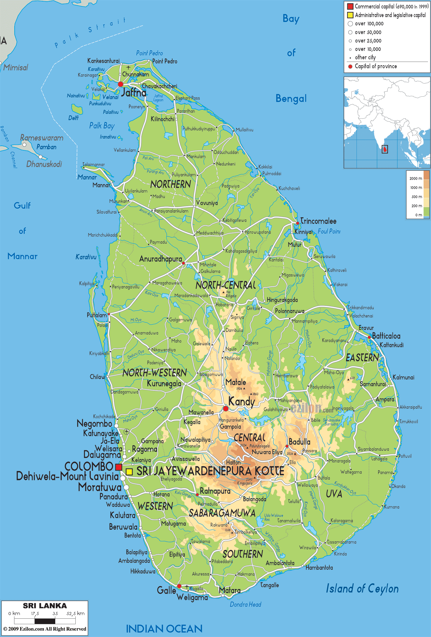
Description: The Physical Map of Sri Lanka showing major geographical features like elevations, mountain ranges, ocean, lakes, plateaus, peninsulas, rivers, plains, landforms and other topographic features.
This map of Sri Lanka with mountains, hills, lakes, rivers and other terrains is already large enough to read directly on your desktop. To see a full-screen zoom view on a phone or tablet, tap the map image (or tap the Zoom Map label above the image). Scan by shading provinces in various colored blocks, with Sri Lanka's mountains, hills, lakes and rivers in bold.
 Detailed Physical map of Sri Lanka showing the central highlands, rivers and coastline, elevations and other topographic features. Sri Lanka is an island nation with no land borders, lying near India across the Palk Strait in the Indian Ocean. It is a part of the
Indian subcontinent. Ceylon is the old name for Sri
Lanka.
Detailed Physical map of Sri Lanka showing the central highlands, rivers and coastline, elevations and other topographic features. Sri Lanka is an island nation with no land borders, lying near India across the Palk Strait in the Indian Ocean. It is a part of the
Indian subcontinent. Ceylon is the old name for Sri
Lanka.
It has maritime boundaries with Maldives to the
southwest and India to the northwest. The Gulf of Mannar
and Palk Strait separates it from the mainland. A chain
of limestone shoals forms a bridge like formation
between India and Sri Lanka. It is situated on the
Indian tectonic plate.
The rain bearing clouds are stopped by the mountain
ranges. 103 rivers can be found in the country. The
Mahaweli River which is 335 kilometres long is the
longest and main river of Sri Lanka. Bambarakanda Falls
with the height of 263 metres is the highest waterfall.
1,585 kilometres is the total length of the coastline of
the country.

Political Map of Sri Lanka
Political map and map image of Sri Lanka.

Road Map of Sri Lanka
Road map and map image of Sri Lanka.

Regional Directory of United States of America
Information and guide about United States of America and websites with American topics.

Regional Directory of Europe
Information and guide about Europe and websites with European topics.

Regional Directory of Australia
Information and guide about Australia and websites with Australian topics.