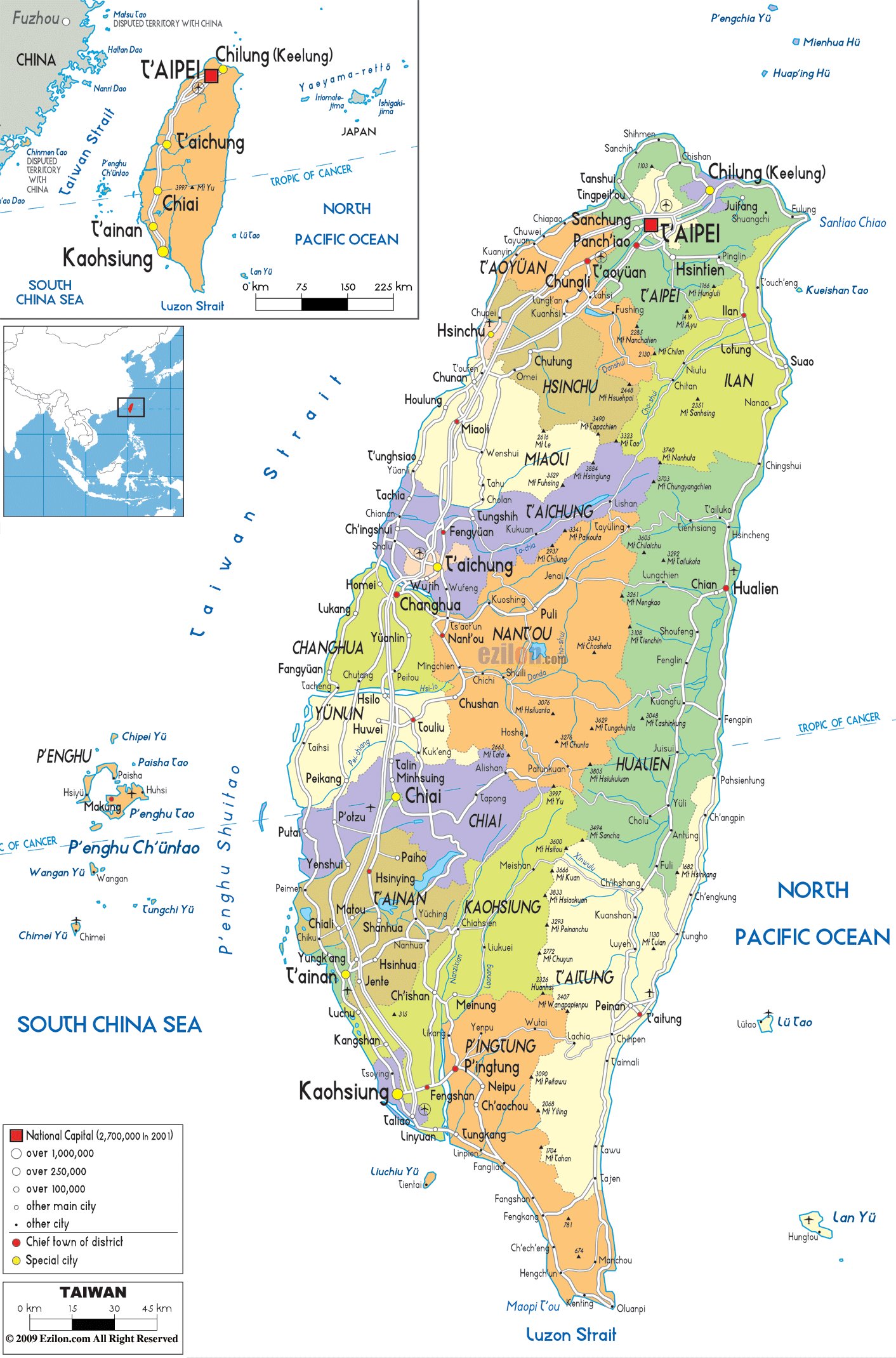
Description: Detailed large political map of Taiwan showing names of capital city, towns, states, provinces and boundaries with neighbouring countries.

The map of Taiwan, with its cities, towns, and municipalities, provides a basic overview of Taiwan's rich political landscape. It primarily focuses on Taiwan's administrative structure and urban network. The Taiwan island map refers to the map of Taiwan, an island located in the southeast of China, separated from the mainland by the Taiwan Strait. The South China Sea lies to the southwest of the island, while the North Pacific Ocean meets the eastern border.
Other islands, such as Penghu, Kinmen, and Matsu, are also marked, indicating that they belong to Taiwan. Since the map has a political rather than a geographical character, it shows county and city boundaries, local names, and transport lines. As a result, it is one of the best map formats for showing where people live and how the island is subdivided into regions.
Taiwan is classified into three levels: six special municipalities, three provincial cities, and 13 counties. The map of Taiwan shows cities and regions colored according to these divisions. The Taiwan map cities layer also shows the special municipalities (Taipei, New Taipei, Taoyuan, Taichung, Tainan, and Kaohsiung). The county seats (Hsinchu, Miaoli, Changhua, Nantou, Yunlin, Chiayi, Pingtung, Yilan, Hualien, Taitung) also show on the map.
A legend explains how the symbols differ in the nation's capital, cities with over 1 million people, medium-sized cities, and small townships. In this manner, readers of the map of Taiwan can read the towns and villages at a glance.
The map of Taiwan with regions will show that the island's administrative divisions are stretched along a north-south axis. Most large cities are located on the western coastal plain. Smaller towns are along the east coast. Taipei City, the national capital located in the north, is marked by a special symbol. It is surrounded by New Taipei City, which wraps around it like a ring. The port city Keelung (Chilung) lies on the northeast coast. The map designates Taoyuan City, then Hsinchu City and Hsinchu County, followed by Miaoli County, south of Taipei, all forming a chain of urban and industrial centers along the upper west coast.
Further south, Taichung City, one of Taiwan's largest municipalities, dominates the central region, along with Changhua County and Nantou County. The map of Taiwan with cities and towns marks Taichung with a large symbol. Likewise, various road lines connect Taichung on this map to surrounding towns, including Fengyuan and Changhua to the southwest, Yuanlin to the south, and Puli to the west. The symbols on this map help the reader visualize how the towns in the inland area of central Taiwan and the coastal towns interact.
Located in the southern part of the island, Tainan City and Kaohsiung City are the two major cities shown on the map, along with Chiayi City, Chiayi County, Yunlin County, and Pingtung County, all of which are densely populated rural and urban communities in the south.
The political and economic center of the island, Taipei, is marked on the northern part of the Map of Taiwan with Cities by a red square symbol and a bold label. New Taipei City is the city that surrounds Taipei, Taiwan's capital. The districts and towns of this city are shown on the Taiwan map cities layer. Some examples include Banqiao, Sanchong, and towns such as Tamsui and Xinzhuang. All these areas are marked with dots or circles. The size of this dot or circle indicates the area's population. To the northeast, Keelung City (Chilung) is designated as a separate port with its own boundary and label, and faces the open Pacific.
Taoyuan City is to the west and southwest of Taipei. An extensive rail and road system connects it to the capital. In fact, both parts of the city are highly urbanized. Many travelers use this northern corridor for air arrivals and for moving into the city.
After Taoyuan, we begin to see Hsinchu County and Hsinchu City. This city represents a high-tech city. Further south, we find Miaoli County, a mostly rural area with smaller towns. These towns and villages are found on the map of Taiwan with small symbols. According to locals and visitors alike, the northern section of the area explains how the greater Taipei urban region links to technology parks and coastal towns in the upper half of the west coast.
The Taiwan map with cities and regions shows the main urban center of central Taiwan, styled Taichung City, enclosed in a large circle and labeled boldly. The map shows Taichung's neighboring towns, such as Fengyuan, Dajia, and Shalu, which are coastal, while Wufeng and Taiping are inland. You can see the road connecting them all. Changhua County, to the south, includes towns such as Changhua City, Yuanlin, and Lukang. The southeast is Nantou County, which includes Nantou City and Puli.
The map labels for Taiwan also show that central Taiwan contains a coherent regional network of industrial coastal settlements, more in the north, and more rural interior townships, more to the south. For geography students, this same region is where the Tropic of Cancer intersects the island. As you will see, it is most certainly included on the map for the study of climates. This is even though the focus is more political than physical.
The city's coverage of the Taiwan map in the south extends from the midwest coast to the Luzon Strait, including several important municipalities and counties. Chiayi City and Chiayi County are in the lower central region, with towns such as Minxiong and Taibao. At the same time, Yunlin County lies just north of it, linking the central and southern regions. The following map shows the urban area of Tainan City and its surrounding districts, along with a link to Kaohsiung City, further south along the western shoreline.
Kaohsiung is one of Taiwan's largest port cities. It is marked by a single prominent symbol and is located near the southwest corner of the main island. Additional symbols mark Fengshan and Zuoying.
The island's southern tip, including Pingtung City and Hengchun, is home to one of Taiwan's largest cities. Along the coast, a string of towns and villages follows before turning toward the Luzon Strait. Pingtung County is the island's extension.
The southern part of Taiwan is where Taiwan's industrial and port activities are concentrated, in Kaohsiung and its neighboring cities. At the same time, its rural and coastal towns radiate outwards along the west and south coasts.
As you take a visual stroll down the map of Taiwan with cities and towns, beginning at the north and ending at the south along the western side of the island, you will move from Keelung and Taipei in the north through New Taipei, Taoyuan and Hsinchu, onward via Miaoli and Taichung down to Changhua and Yunlin and lastly to Chiayi, Tainan, Kaohsiung and finally, Pingtung at the southern tip.
The series of city names and road lines reveals the major urban corridor where the majority of Taiwan's population and industries are concentrated. It is useful to both travelers and economic geographers. The layer depicting cities on the Taiwan map shows major highways that run parallel to this corridor. The pattern of movement between the big cities becomes easy to imagine. One does not even need the terrain's physical characteristics to gather it.
If you start from Keelung and follow the east coast on the map of Taiwan, you see a more spaced-out series of towns, such as Yilan City, Hualien, and Taitung, each representing a county seat along the Pacific shore.
The routes established between these locations follow the shoreline and illustrate the less urbanized nature of the eastern side, which remains connected by a consistent route used by those seeking to travel there. Offshore, the map also includes the Penghu Islands (Pescadores) in the Taiwan Strait, along with Kinmen and Matsu, not far from the Chinese coast, shown in small outlines and labeled to indicate their connection to Taiwan.
Taiwan's cities and regions map places Taiwan within its maritime and regional context. To the west of Taiwan lies the Taiwan Strait, which separates the island from the mainland of China. In some inset maps, marks coastal cities like Fuzhou, which many viewers may need to know about. A strategic location at the intersection of important maritime routes: south connects to the Luzon Strait, which links to the Philippines; southwest depicts the South China Sea; and east marks the North Pacific Ocean.
This context is especially useful for users searching for a map of Taiwan's cities and towns as part of broader travel planning in East Asia. It helps to clarify ferry routes, flight directions, and regional geography around the island. Many political maps of Taiwan, including the one you are using, feature inset maps showing Taiwan in relation to other countries in East and Southeast Asia. In addition to tourism, this is useful for studies in international relations.
The political Map of Taiwan, with towns and villages, uses different symbol sizes to represent population categories, ranging from special municipalities to small townships. Taipei, New Taipei, Taichung, Tainan, Kaohsiung, and Taoyuan are presented in thick circles to highlight their importance as urban centers and administrative cities of Taiwan. Medium-sized cities in Taiwan, such as Hsinchu, Chiayi, Keelung, Yilan, Hualien, Pingtung, and Taitung, are represented in a single layer of slightly smaller symbols on the map, which are equally easy to spot.
A small dot or a name (without any other symbol) represents a smaller town or a rural township. Thus, the map of Taiwan is filled with the names of the different towns and villages found between the large cities. According to the residents, it shows where major services, such as hospitals, universities, and transport hubs, are located in relation to your smaller hometown. Students can visually see how large cities and towns relate to one another.
A map of Taiwan with capitals and towns will be highly useful to practically every section of the population, because it brings together administrative boundaries, major cities, smaller towns, routes, and maritime surroundings. The residents may use it to locate their municipality or county, identify which special municipality or county capital is closest, and see how highways connect them to major transport hubs, including Taipei, Taichung, and Kaohsiung.
Travelers can plan their routes depending on their preferences, from Taipei down the west coast or around the island, including Taroko in Hualien, the east coast near Taitung, or the offshore Penghu Islands. These places are clearly marked on the map of Taiwan, with cities and regions.
For geography students, the outline map of Taiwan with regions is an excellent study material that shows the island's 22 top-level administrative divisions, including special municipalities, provincial cities, and counties, as per the current government administrative setup.
Because political maps do not intentionally depict mountains, rivers, and other physical features, learners would first look at human geography and learn about political boundaries, population centers, transport corridors, and maritime contexts. After this, they will merge this with physical maps for deeper learning.
Taiwan is located off the southeast coast of China, separated by the Taiwan Strait.
The map shows the Taiwan Strait, South China Sea, Luzon Strait, and North Pacific Ocean around Taiwan.
The map shows Penghu, Kinmen, and Matsu as offshore islands belonging to Taiwan.
The political map shows 22 top-level administrative divisions including special municipalities, provincial cities, and counties.
Taipei City is shown as the national capital and political center of Taiwan.
Major municipalities shown include Taipei, New Taipei, Taoyuan, Taichung, Tainan, and Kaohsiung.
Taipei is located in northern Taiwan and is surrounded by New Taipei City.
Cities and districts surrounding Taipei include Banqiao, Sanchong, Tamsui, and Xinzhuang within New Taipei City.
Keelung is located on the northeastern coast of Taiwan facing the Pacific Ocean.
Northern areas shown include Taipei, New Taipei, Keelung, Taoyuan, Hsinchu City, Hsinchu County, and Miaoli County.
Taoyuan is important because it forms part of Taiwan's major urban and transport corridor linked to Taipei.
Hsinchu is located southwest of Taoyuan along Taiwan's upper western corridor.
Central Taiwan regions shown include Taichung City, Changhua County, and Nantou County.
Towns around Taichung shown on the map include Fengyuan, Dajia, Shalu, Wufeng, and Taiping.
Changhua County towns shown include Changhua City, Yuanlin, and Lukang.
Nantou County towns shown include Nantou City and Puli.
The Tropic of Cancer is shown crossing central Taiwan.
Southern Taiwan regions shown include Yunlin County, Chiayi City, Chiayi County, Tainan City, Kaohsiung City, and Pingtung County.
Kaohsiung is located near the southwestern coast of Taiwan.
Districts around Kaohsiung shown include Fengshan and Zuoying.
Pingtung County towns shown include Pingtung City and Hengchun.
East coast cities shown include Yilan City, Hualien, and Taitung.
The east coast shows more widely spaced towns while the west coast contains Taiwan’s major urban corridor.
The map highlights major north–south transport corridors linking Taipei, Taoyuan, Taichung, Tainan, Kaohsiung, and Pingtung.
Maritime areas shown include the Taiwan Strait, South China Sea, Luzon Strait, and Pacific Ocean.
The map references mainland China and the Philippines as nearby regional neighbors.
Major municipalities are shown with larger symbols while smaller towns and villages appear with smaller dots.
Travelers can use the map to follow urban corridors, coastal routes, and ferry connections between cities and islands.
The map helps geography students study administrative divisions, urban networks, transport corridors, and regional relationships.
No. Printing or copying maps from this site is not permitted.

Physical Map of Taiwan
Physical map and map image of Taiwan.

Road Map of Taiwan
Road map and map image of Taiwan.

Regional Directory of United States of America
Information and guide about United States of America and websites with American topics.

Regional Directory of Europe
Information and guide about Europe and websites with European topics.

Regional Directory of Australia
Information and guide about Australia and websites with Australian topics.