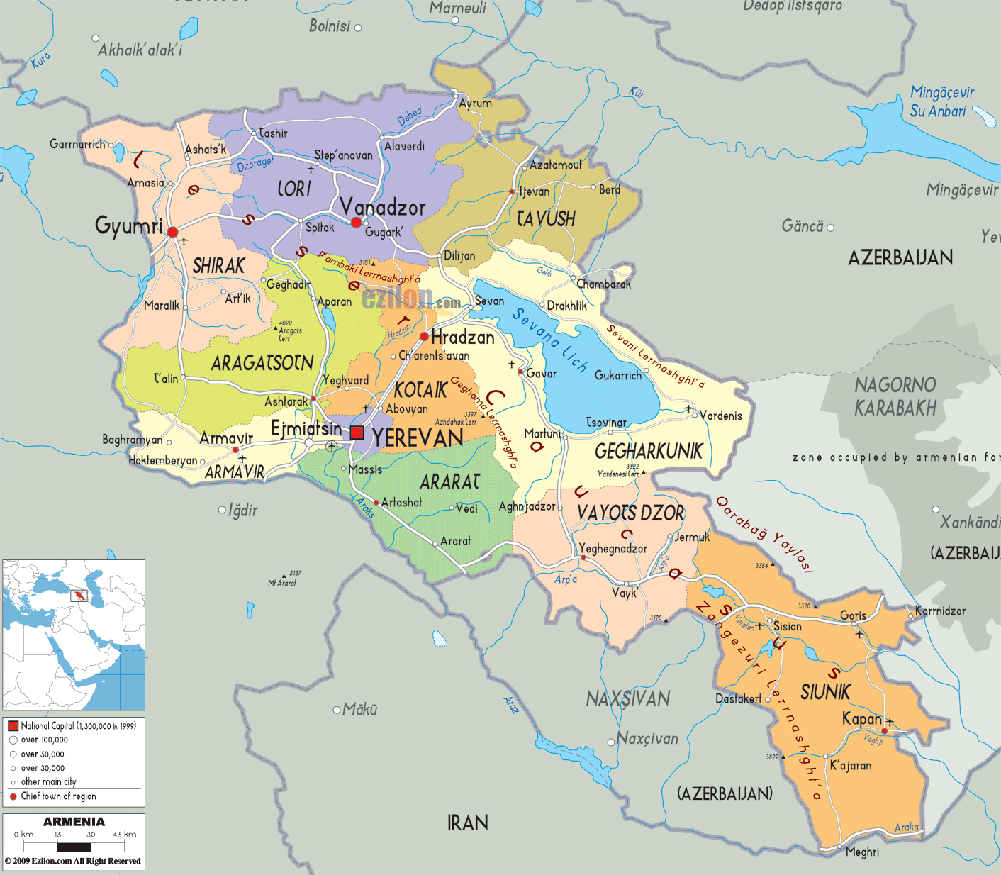
Description: Detailed large political map of Armenia showing names of capital cities, towns, states, provinces and boundaries with neighbouring countries.
 Map of Armenia: central cities, road network, and cities. This page is built around a detailed map that lets you follow the whole country at a glance. Our Armenia map with cities shows the eleven first-level units - ten provinces and the capital Yerevan - together with key towns, highways, and border crossings that link Armenia to Georgia, Iran, Turkey, and Azerbaijan. Because the map is the best visual for this style, you can read this guide while tracing every province, lake, mountain, and road on the sheet.
Armenia is a landlocked country in the South Caucasus, in the Armenian Highlands of West Asia. It is bordered by Georgia to the north, Azerbaijan to the east, Iran to the south, and Turkey plus the Azerbaijani exclave of Nakhchivan to the west and southwest. Yerevan is both the capital and the largest city, and it appears near the center of our map, anchoring the national road network and much of the population.
Looking at the map of Armenia, you can see how the country sits between the Black and Caspian Seas, in a region often called Transcaucasia. The outline forms a rough rectangle tilting from northwest to southeast. The western side faces Turkey and the Nakhchivan exclave, the northern edge touches Georgia, the eastern frontier runs against Azerbaijan, and the southern strip borders Iran.
The relief on the map reminds you that Armenia is a highland country. Much of its territory lies above 1,000 metres, with volcanic plateaus and rugged mountains dominating the view. Significant peaks are not all named on this political map, but you can infer the high ground from province boundaries and the routes of the main roads. The central and western lowlands around the Ararat plain are flatter and more fertile, which explains why many cities cluster there.
Because Armenia is landlocked and some borders are effectively closed, the open trade corridors with Georgia and Iran are critically important. On our map of Armenia, the roads that run north toward Tbilisi and south toward the Iranian border posts stand out as strategic lifelines for residents and businesses.
This detailed map shows how Armenia is divided into its ten provinces (marzer) and the city of Yerevan. Yerevan, a special status unit in the center, is surrounded by 10 provinces: Shirak, Lori, Tavush, Aragatsotn, Armavir, Ararat, Kotayk, Gegharkunik, Vayots Dzor, and Syunik. Provincial capitals, such as Gyumri in Shirak or Vanadzor in Lori, are marked as major cities, and smaller towns appear as additional dots along the roads.
The road network is depicted as a clean, linear network of links that follow valleys and plains. While not every road number appears, the map makes it easy to follow the north-south axis from the Georgian border to Iran, as well as the east–west links across the Ararat plain and toward Lake Sevan. This makes the Armenia road map section useful for both route planning and geographic orientation.
Since the provinces act very much like states for residents, this Armenia map with cities and regions shows you where each community fits in the country. For tourists and geography students, the color coding and distinct labeling make this teaching tool the best map style. The color coding visually connects natural features and borders with human settlements.
In the northwest of the map, you will see Shirak Province, shaded in its own color and bordered by Georgia to the north and Turkey to the west. The provincial capital, Gyumri, stands out as a significant symbol of the city. Gyumri is Armenia's second-largest city and is long known for its arts, crafts, and distinctive architecture.
Following the road lines on the map, you can trace how routes from Gyumri head north to the Georgian frontier and southward toward Aragatsotn and Yerevan. Smaller towns such as Maralik and Amasia appear as local centers. For someone planning a visit, the detailed map makes it clear that Shirak is a border plateau, connecting Armenia to both Georgia and Turkey while also feeding traffic into the central corridor.
Directly south of Shirak lies Aragatsotn Province, with its capital Ashtarak, marked on the map just northwest of Yerevan. This province sits at the foot of Mount Aragats, Armenia's highest mountain, which dominates the western skyline even though it is not individually labeled on this political map.
Our Armenia map with cities shows Ashtarak as a junction where roads from Gyumri and the western villages meet the main route into Yerevan. Smaller settlements such as Aparan and Talın appear along the highland roads that loop around the mountain. For geography students, this pattern demonstrates how mountain slopes and river valleys determine where roads and population centers can be located in a high plateau environment.
Moving slightly south and west on the map brings you to Armavir Province, whose capital, Armavir, and major city Ejmiatsin (Vagharshapat) are both visible near the Araks River and close to the Turkish border. This area is rich in cultural sites and fertile farmland.
The map shows how roads fan out from Ejmiatsin toward Yerevan, Gyumri, and the border crossings, illustrating why this province has long been a crossroads of trade and religion. The Araks River, which forms part of the frontier with Turkey and Nakhchivan, is delineated by the international boundary lines that bend along the southern edge of the province.
Southeast of Armavir, our detailed map highlights Ararat Province, named after the iconic Mount Ararat across the border in Turkey. Its capital, Artashat, appears south of Yerevan on the broad Ararat plain, a key agricultural zone.
Roads drawn on the map leave Yerevan and run through Ararat toward border areas and smaller towns such as Masis. This makes it clear that Ararat Province is a southern gateway, facing both Nakhchivan and the open trade corridor with Iran to the east. For residents and logistics planners, the combination of flat terrain and proximity to the border explains why the region supports intensive farming, industry, and transport infrastructure.
The map of Armenia with cities shows Yerevan at the centre, a distinct unit surrounded by multiple provinces. Yerevan is home to approximately a third of Armenia's total population.
From Yerevan, you can visually follow:
Westward roads into Armavir and toward Turkey and Nakhchivan
Northwest links into Aragatsotn and further to Shirak
Northeast connections into Kotayk, Gegharkunik, and Lori
Southward routes into Ararat and then toward Vayots Dzor and Syunik
Because the map keeps the capital central, it helps travelers plan day trips to almost every province. Geography students can also see how Yerevan acts as a hub in the national road system, despite Armenia's mountainous terrain.
Looking at the north central area of the map, you will find Lori Province, bordered by Georgia to the north. Its capital, Vanadzor, is marked as a major city, and towns like Spitak and Stepanavan appear along valley routes. MyArmenia+1
The roads shown in Lori mainly follow river valleys that cut through forested hills. This gives a real sense of how industry and towns are strung along transport corridors. For travelers who want to explore monasteries, canyons, and green landscapes, our map of Armenia makes it easy to see how close Lori lies to both Yerevan and the Georgian border.
East of Lori, the map shades Tavush Province, known for its forests and the spa town of Dilijan near the province's border. The administrative center, Ijevan, is not labelled, but the province itself is clearly shown extending toward Azerbaijan and Georgia.
On the Armenia map with cities, the key visual element in Tavush is the northeastern edge, where border lines meet Azerbaijan. This illustrates why the region is strategically important and why roads running through Dilijan toward Lake Sevan and Georgia serve as vital transit links for both trade and tourism.
North and east of Yerevan is Kotayk Province, with Hrazdan as its capital. Kotayk is home to resorts like Tsaghkadzor and cultural sites around Garni and Geghard. While not every site label appears on this political map, you can see Kotayk's position wrapping around Yerevan and bridging the route toward Lake Sevan.
The roads through Kotayk show how easily Yerevan residents can reach mountain ski slopes and canyon monasteries. The province serves as a demonstration for student geographers of how tourism, agriculture, and industry can coexist in a compact, highland setting on the metropolitan fringe.
Further east, the map highlights Gegharkunik Province, dominated by Lake Sevan, one of the largest high-altitude freshwater lakes in Eurasia. The provincial capital Gavar and the town of Sevan appear on the lakeshore, while Martuni, Chambarak, and Vardenis mark other key settlements.
Because nearly a quarter of Gegharkunik is covered by Lake Sevan, the map uses blue shading to highlight the water body. Roads run along the lakeshore and link back toward Yerevan through the Sevan pass. Travelers can read the map to find beach resorts, monasteries, and viewpoints, while researchers can see why the province plays a significant role in Armenia's water resources and tourism economy.
South of Gegharkunik and east of Ararat, our detailed map shows Vayots Dzor Province, with its capital, Yeghegnadzor. This region is known for wine villages like Areni and spa towns such as Jermuk, some of which appear on the map.
The road network in Vayots Dzor runs along the Arpa River valley and then climbs toward Syunik. On our Armenia map with cities, these roads form a southern highland corridor linking Yerevan to the Iranian border, traversing rugged, scenic terrain.
At the bottom right of the map is Syunik Province, stretching from the center of the country down to the frontier with Iran. Its capital, Kapan, and other towns such as Goris, Sisian, Meghri, and Kajaran are clearly labelled along a curving north–south road. Reuters+1
The road shown here is more than a simple highway. Syunik provides Armenia's only direct land connection to Iran, making this route a lifeline for trade and energy supplies, mainly because links to Turkey and Azerbaijan are restricted. On the map, you can see how this corridor runs between Azerbaijani territories to the east and the Nakhchivan exclave to the west, underlining the province's strategic location in the South Caucasus.
For travelers, the Syunik section of the map highlights deep gorges, historic monasteries, and the famous Tatev area, accessible from near Goris, even if not every site name is visible. For geography students, Syunik illustrates how narrow corridors and border politics shape transport patterns in a landlocked country.
Our detailed map of Armenia works on several levels at once. Residents can see how their home cities relate to provincial boundaries, border crossings, and the capital Yerevan. People traveling and doing business can see how main roads pass through the provincial centers. The provincial centers are Gyumri, Vanadzor, Kapan, and Meghri.
Visitors can use the map of Armenia with cities to create loops that combine cultural stops with highlights of the landscape. For example, the loop from Yerevan to Gyumri, then Vanadzor, Dilijan, Lake Sevan, around Vayots Dzor, and again through Ararat. Because every province is color-coded and all key towns and lakes are shown, the map is the best reference for planning multi-day routes.
Geography students and researchers can use the map to address questions on highland settlement, border zones, hydrology, and regional development. The map's large size of Lake Sevan suggests problems with water management. The road layout follows the valleys and the plains that interrupt the mountains of Armenia.
By reading this guide while following the detailed map of Armenia, you gain an integrated picture of how provinces, cities, roads, and borders fit together in a compact but complex South Caucasus country.

Physical Map of Armenia
Physical map and map image of Armenia.

Road Map of Armenia
Road map and map image of Armenia.

Regional Directory of United States of America
Information and guide about United States of America and websites with American topics.

Regional Directory of Europe
Information and guide about Europe and websites with European topics.

Regional Directory of Australia
Information and guide about Australia and websites with Australian topics.