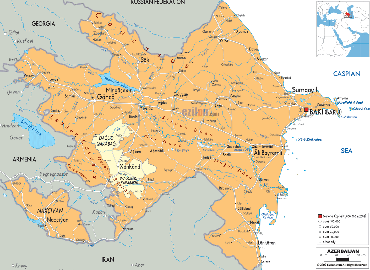
Description: Detailed large political map of Azerbijan showing names of capital cities, towns, states, provinces and boundaries with neighbouring countries.

Detailed map of Azerbaijan with cities, towns, districts, villages and surrounding countries. Map of Azerbaijan, Azerbaijan map with cities, major cities, and road network - this guide is written so you can follow our detailed map step by step. The Azerbaijan map with cities shows the whole country from the Greater Caucasus in the north to the Iranian frontier in the south, and from the Georgian border in the west across to the Caspian Sea coast in the east. Because our sheet is a detailed map with clearly drawn districts, towns, rivers, and roads, it is one of the best reference maps for residents, travelers, and geography students.
Azerbaijan lies at the intersection of Eastern Europe and Western Asia. Azerbaijan is bordered by Russia to the North, Georgia to the northwest, Armenia to the west, Iran to the south, and a long eastern shoreline by the Caspian Sea. The Nakhchivan Autonomous Republic appears on the map as an exclave, separated from the main territory by Armenian territory, and borders Armenia, Iran, and Turkey. The capital city, Bakı (Baku), sits on the Absheron Peninsula, facing the Caspian Sea, and is marked on the map as a prominent square symbol with surrounding coastal suburbs.
If you look at the outline of Azerbaijan on our map, you see a broad lowland in the center and east and higher ground to the north, west, and south. The mountains that make up the Greater Caucasus run along the northern border with Russia and parts of the border with Georgia. The Highlands of the Lesser Caucasus lie in the western and southwestern parts of the country, around the regions of Qazax, Ganja, and the Karabakh uplands. The central and southern areas fill the plains of the Kur and Araz rivers, which flow to the Caspian coast.
This geography explains the pattern of cities and roads. Towns located at the foot of the mountains, where valleys opening toward the mountains are most abundant, are Guba, Qusar, Sheki, etc. Baku, Sumqayıt, and Gəncə (Ganja) are larger cities. They find areas with flatter topography for easy transportation. Azerbaijan’s map suggests that river valleys and low passes are followed, while towards Georgia, Russia, and Iran, border crossings fan out.
The Azerbaijan map with cities also shows neighbouring capitals and external reference points at the frame edges, such as Tbilisi, Georgia, and Russian territory to the north. This makes it easier to understand how Azerbaijan connects to the wider South Caucasus and Caspian region.
Our detailed map shows Azerbaijan with its districts and cities labelled in Latin script. The principal area is shaded in orange, while lighter shades are used for Dağlıq Qarabağ (the Nagorno-Karabakh) and other districts that have undergone political changes. The Nakhchivan Autonomous Republic in the southwest corner is marked distinctly and labelled Naxçıvan. The Nakhchivan Autonomous Republic in the southwest corner is shaded separately and clearly labelled as Naxçıvan.
Major cities are drawn with larger symbols and bold names:
Bakı (Baku) on the Absheron Peninsula
Sumqayıt is to the northwest of Baku along the coast
Gəncə in the central western area
Mingəçevir, near the large reservoir on the Kur river
Lənkəran and coastal towns in the south
Naxçıvan city inside the exclave
Smaller district centers such as Şəmkir, Yevlax, Qazax, Quba, Qusar, Şirvan, Salyan, Masallı, Cəlilabad, Astara, and many more appear as dots along road lines. When you follow the network on the map, you see how these towns link the agricultural lowlands, mountain villages, and Caspian seaports.
The road network on the Azerbaijan map with cities is drawn as clean lines rather than numbered highways. Key axes stand out:
A north–south corridor along the coast from the Russian border through Qusar, Quba, Sumqayıt, Baku, and down toward Salyan and Astara.
A west–east corridor from the Georgian border through Qazax, Tovuz, Şəmkir, Gəncə, Yevlax, and onward toward Baku.
Routes that branch into the Karabakh uplands, the Mugan plain, and the Lankaran lowlands, as well as roads crossing into Nakhchivan and toward Iran.
Because many rivers and canals are also drawn, residents and researchers can easily match transport lines to river basins and irrigated zones.
The map shows that the Absheron Peninsula, among others, juts out into the sea. On its south side, you can see Bakı (Baku) marked, which is the national capital shown with a square symbol. Surrounding names such as Ələt, Qaradağ, Suraxanı, and nearby islands like Xilə Zira Adası and Pirallahı Adası show how the city extends along the shore and over the broader metropolitan area.
Our Map of Azerbaijan is detailed enough to follow roads leading from Baku. One road goes northwest to Sumqayıt and then continues to Quba and Qusar. Another road leads westward towards Şamaxı, Kürdəmir, Yevlax, and Gəncə, while a southern corridor follows the coastline to Salyan, Neftçala, and Lənkəran. Due to the abundance of oil and gas, Baku is the centre of trade and administration.
Northwest of Baku, on the coast, Sumqayıt stands out as a large city on the map. It is part of the densely populated Absheron economic region, known for industry and housing. Between Baku and Sumqayıt, towns such as Xırdalan are shown along the highway, forming a continuous urban corridor.
Further up the coast, the map shows smaller coastal towns and ports that connect the Caspian Sea with inland areas. For travelers, this makes the Azerbaijan map with cities helpful in planning day trips from Baku to beaches, mud volcanoes, and historic villages on the peninsula.
In the northeast corner of the main territory, near the Russian border, you will find Quba and Qusar. They are shown as important towns where roads climb from the lowlands into the Greater Caucasus. The border outline shows Azerbaijan bordering the Russian Federation in this segment, with roads from Quba and Qusar leading to border crossings and mountain valleys.
On our detailed map, the rivers that cut through this region help you see why roads follow particular lines. Geography students can use this part of the Azerbaijan map with cities to study how mountain slopes and river valleys shape settlement in the highlands and how transport corridors connect to lowland agriculture.
Walking your eyes along the northern border toward the west, you meet towns such as Qax, Zaqatala, and Balakən along the Georgian frontier, and slightly south, you see Şəki (Sheki), known for its historic architecture. The map places these towns in narrow valleys at the foot of the mountains, with roads linking them to both Georgia and the central Kur-Araz lowland.
Our Azerbaijan map with city names includes many of these towns, which can be helpful for travelers seeking to explore traditional caravan routes, mountain scenery, or cross-border trips into Georgia. Planners and residents can likewise view these districts as border gateways for trade and cultural exchange.
The map shows the city of Ganja, located north of the center and to the left of the main territory, as a critical city symbol. This city is the second most important to Baku and Sumqayıt. The Georgian border roads at Qazax and Tovuz converge on Gəncə, with other roads going east to Yevlax, Bərdə, and Goranboy.
The area around Gəncə lies in the Kur river basin, at the edge of the Lesser Caucasus foothills. The detailed map shows irrigated zones and canals heading south and east, which explains why this region is both an industrial and agricultural hub. On the Azerbaijan map with cities, Gəncə clearly stands as the anchor of western Azerbaijan.
North of Gənja, the town Mingachevir is marked near the large Mingachevir reservoir on the Kur river. The map shows the river flowing southeast across the country, with road and settlement names following its course. Nearby Yevlax sits at a key juncture where highways cross the Kur and spread outward to Gəncə, Bərdə, Ağdaş, and Göyçay.
This part of the map is beneficial for geography students because it illustrates how major rivers support hydropower, irrigation, and settlement. The combination of river lines, reservoirs, roads, and towns makes this one of the best examples of a lowland corridor in the South Caucasus.
In the south-central area of Azerbaijan, our map highlights Dağlıq Qarabağ (Nagorno Karabakh) and surrounding districts, such as Ağdam, Füzuli, Cəbrayıl, and Qubadlı, in a lighter colour. Cities including Xankəndi and Şuşa are labelled inside this zone. The region has been subject to conflict and status changes over time, so the map should be read as a representation tied to its publication date rather than a current political statement.
From a strictly geographic point of view, this section of the Azerbaijan map with cities shows a transition from the Lesser Caucasus uplands into the Kur river plain. Roads ascend from Bərdə and Ağcabəi, two lowland settlements, to the hilly ground until they reach the Armenian border and the Iranian frontier further south.
The Mugan plain extends to the Caspian coast southeast of the Karabakh highlands. Towns like Beyləqan, İmişli, Saatlı, and S birabad are marked on the map, which connects them with roads and irrigation. South of the Kur, the Araz river forms large parts of the border with Iran, and towns like Biləsuvar and Cəlilabad appear near the frontier.
When you follow these roads across the map, you see how the Kur-Araz lowland supports cotton, grain, and other crops. Residents, agronomists, and planners can use this part of the detailed map to understand water management and transport links in one of Azerbaijan’s key agricultural zones.
At the bottom right of the main territory, our Azerbaijan map with cities shows the Lənkəran lowlands, squeezed between the Caspian Sea and the Talish Mountains near the Iranian border. Coastal towns such as Lənkəran, Asara, and Masallı are clearly labelled. Roads hug the coast and run parallel to the mountains, then connect back toward Salyan and Baku.
This region is known for a mild, humid climate and tea plantations, which you can infer from the map by the combination of low altitude coastline and nearby mountain slopes. For travelers, the towns in this area form a scenic route between Baku and the Iranian border. Students illustrate how coastal lo lands differ from the drier Mugan and Kur plains farther west.
In the far southwest of the entire sheet, the Nakhchivan Autonomous Republic appears as a separate block bordered by Armenia, Iran, and a short border with Turkey. The capital city, Naxçıvan, is notable, and roads connect it to significant settlements such as Şərur, Ordubad, Culfa, and Şahbuz.
The map shows that the Araz river runs along much of the southern boundary with Iran, while mountain ridges separate Nakhchivan from Armenia to the north and east. For residents, this region is an integral part of Azerbaijan; for map readers, it is also a good case study of an exclave and how transport must cross foreign territory or use air corridors to connect with the central part of the country.
A detailed map of Azerbaijan helps residents integrate local districts into the national picture. A person in Quba can use it to show which road leads to Baku and which leads to Russia. In İmişli, a farmer sees the rivers and canals connecting their fields with the Kur and Araz basins. A student in Gəncə can race the route of the railway and highway network toward Georgia and Baku.
For travelers, the Azerbaijan map with cities is one of the best map references for planning trips that combine coastal cities, mountain resorts, and historic inland towns. You can visually design a loop that starts in Baku, runs to Quba and Qusar in the north, crosses to Şəki and Zaqatala, visits Gəncə and Mingəçevir, then drops south into the Mugan plain and finally returns to Baku along the Lənkəran coast.
For geography students and researchers, the map supports more analytical work. In this image, you’ll see how the Greater Caucasus and Lesser Caucasus, as well as the Talish Mountains, frame the Kur-Araz lowland. Further, you will see that rivers, reservoirs, and canals structure human settlements.
It also provides a visual record of district boundaries and special regions at the time of publication, allowing comparison with newer data.
Azerbaijan is long and narrow, strategically situated on the Caspian Sea just across the water from Kazakhstan, Turkmenistan, and Iran, and just south of the Russian Federation. By using our Azerbaijan map alongside this lengthy description, you gain a multi-layered understanding of how cities, districts, mountains, plains, rivers, and roads fit together within this strategically located Caspian country.

Physical Map of Azerbaijan
Physical map and map image of Azerbaijan.

Road Map of Azerbaijan
Road map and map image of Azerbaijan.

Regional Directory of United States of America
Information and guide about United States of America and websites with American topics.

Regional Directory of Europe
Information and guide about Europe and websites with European topics.

Regional Directory of Australia
Information and guide about Australia and websites with Australian topics.