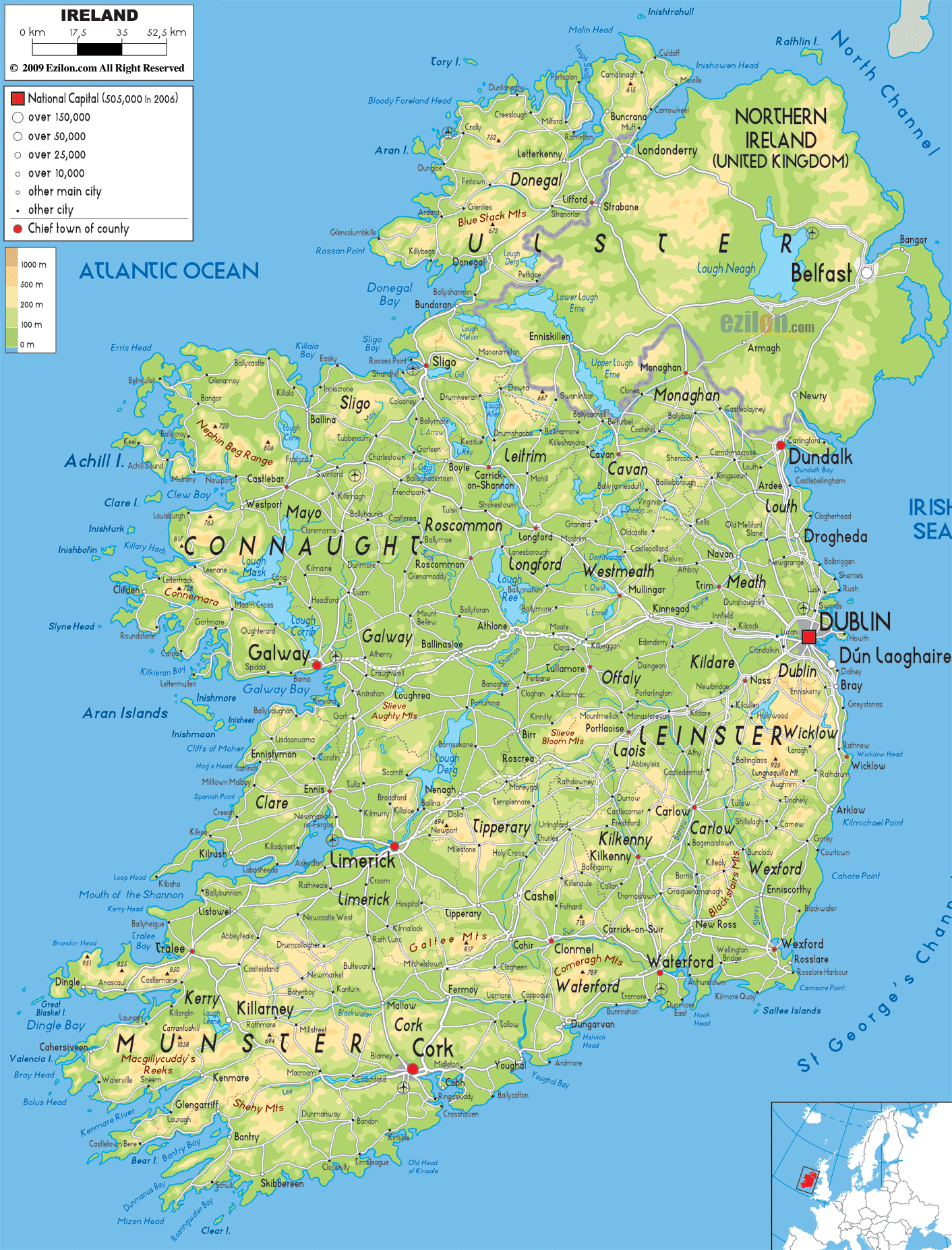
Description: The physical map of Ireland showing major geographical features like elevations, mountain ranges, seas, lakes, plateaus, peninsulas, rivers, plains, landforms and other topographic features.
 When you examine this detailed physical map of Ireland image above, you're looking at one of Europe's most geographically diverse and naturally beautiful islands. This comprehensive guide reveals the intricate topography, river systems, coastal features, and elevation patterns that have shaped Ireland's landscape over millions of years. If you are a geography student who is looking at how a landform develops, if you are a traveler looking to visit Ireland's natural wonders, or if you are a map lover who enjoys looking at physical geography, this map tells the full story of Ireland's nature.
As you study this physical map, the elevation legend on the left reveals Ireland's topographical diversity through a color-coded system ranging from sea level (0m) to the highest elevations (1000m+). The greens are softer and dominate the “green isle” of Ireland due to its low modelling with golds & brown highlighting the mountainous island. The central lowland of Ireland is surrounded by highland areas along the coastline creating an elevation pattern giving Ireland a bowl shape.
The map exhibited illustrates the manner in which Ireland's landscape has been shaped by glacial activity, river erosion and coastal processes over time. Ireland's longest river, the River Shannon, flows through the middle part of the island, while other less important rivers form a vast drainage system which is within the valleys, plains and coastlines of the country.
The area of light green colour in Centarl Ireland represent the Great Central Plain. Its a bleatufl area of rolling hills, farmland and huge bog systems. This lowland area, usually no more than 100 m above sea level, forms the agricultural heart of Ireland and shows how glacial deposits created one of Europe's best farmland.
The River Shannon, which is easy to spot meandering through the central lowlands, is Ireland's most important geographical feature. The source of the shannon is the cuilcagh mountains it is located near the border of northern Ireland. It flows approximately 360km into the atlantic. The mouth of the shannon is the shannon estuary near limerick.
The Shannon creates important features that can be seen on Shannon Map:
Lough Ree - A large lake in the upper Shannon system, visible in the Roscommon-Westmeath border region
Lough Derg - The Shannon's largest lake, stretching across the Tipperary-Clare-Galway borders
Shannon Estuary - The wide tidal mouth where the river meets the Atlantic Ocean
The Shannon system joins with a large number of tributaries which drain the central plain, including rivers flowing from the highlands surrounding it. Over the years, this network has provided a route system for transport and continues to help tourism on Ireland's inland waterway.
The central lowlands don't have any reliable markings on this physical map, although there are likely extensive peat bog systems here. They are essentially flat, low-lying regions.
Peat bogs, formed after thousands of years in glacial landscapes that poorly drained, are precious ecosystems in their own right and have supplied Irish communities with fuel for centuries.
County Donegal displays some of Ireland's most dramatic topography, with the golden and brown coloring indicating significant elevation changes and mountainous terrain. The highland setting of the Blue Stack Mts and Derryveagh Mts entails the highest peaks in Ireland, after Kerry and Cork.
The map shows how Ireland’s most severe Atlantic coastline is found on the Donegal circuit.
Bloody Foreland Head - The northernmost point of mainland Ireland
Malin Head - Ireland's northernmost point, extending into the Atlantic
Inishowen Peninsula - The large peninsula between Lough Foyle and Lough Swilly
Fanad Head and Rosguill Peninsula - Distinctive coastal projections into the Atlantic
The map shows how these coastal features create numerous bays, inlets, and headlands that have provided natural harbors while also creating some of Europe's most spectacular coastal scenery.
The physical map reveals numerous small lakes scattered throughout Donegal's mountainous terrain. These glacial lakes were carved by ice age glaciers and now provide both scenic beauty and important freshwater resources for the region.
In County Galway, the western region known as Connemara appears in golden tones, indicating the elevated terrain of the Twelve Bens mountain range. The quartzite mountain range in Ireland accounts for some of the country's best-known peaks, while it also acknowledges Connemara’s place as one of Europe's last great wildernesses.
Galway Bay, clearly visible as a large indentation in Ireland's western coast, represents one of the country's most significant coastal features. For centuries, maritime activity has prospered in the sheltered waters of the bay, while the coastal plain provides fertile agricultural land.
The Aran Islands (Inishmore, Inishmaan, and Inisheer) are little patches of land found in Galway Bay, the islands are limestone plateaus that rise directly from the Atlantic Ocean. These islands show that Ireland's geology is great offshore.
The northern Burren uplands of County Clare drop to the Shannon Estuary in the south. Thus, we see a wonderful variety. The map illustrates Clare's coast faces the full brunt of the Atlantic creating dramatic cliffs and other coastal features.
The Shannon Estuary, which is the large body of water that can be viewed between Clare and Kerry. It is by far one of the most important estuarine systems in Ireland. One that acts as a waterway for seafaring shipping traffic but also supports spectacular wildlife.
County Mayo showcases remarkable geographical diversity, from the elevated terrain of Croagh Patrick and the Nephin Beg Range to the extensive coastal plains and offshore islands.
Clew Bay, clearly visible as a large sheltered bay on Mayo's western coast, contains numerous small islands (traditionally said to number 365) that appear as tiny green dots on the map. This drowned drumlin landscape was created by glacial action and subsequent sea level rise.
Achill Island, Ireland's largest island, appears connected to the mainland by a bridge. The map shows how this island contains significant elevation changes, with mountainous terrain rising directly from the Atlantic coastline.
County Kerry displays Ireland's most dramatic mountain landscapes, with extensive areas of golden and brown coloring indicating the highest elevations in the country. The MacGillycuddy's Reeks mountain range is home to Carrauntoohil, Ireland's highest peak at 1,038 meters.
The well-known touristic Ring of Kerry route runs around the Iveragh Peninsula's coastline which is a large projection into the Atlantic Ocean. The map indicates that the peninsula consists of mountains and cliffs at the sea's edge:
Dingle Bay - The large bay separating the Iveragh and Dingle peninsulas
Kenmare River - Actually a long sea inlet (ria) extending inland between Kerry and Cork
Skellig Islands - Small islands off the Kerry coast (visible as tiny dots)
The Dingle Peninsula appears as another major coastal projection, with mountainous terrain rising directly from the Atlantic. This peninsula represents one of Ireland's most important Gaeltacht (Irish-speaking) regions and contains some of the country's most spectacular coastal scenery.
County Cork displays significant topographical diversity, with mountain ranges in both the western and northern parts of the county. The Caha Mountains along the Kerry-Cork border and the Boggeragh Mountains in north Cork create elevated terrain that contrasts with the river valleys and coastal plains.
The map clearly shows Cork Harbour, one of the world's largest natural harbors, formed where several rivers converge before reaching the sea. The River Lee flows through Cork city, while numerous other rivers drain the county's diverse terrain.
County Wicklow, often called the "Garden of Ireland," displays significant elevation changes just south of Dublin. The Wicklow Mountains, appearing in golden tones on the map, represent the northern extension of the Leinster Chain and include some of eastern Ireland's highest peaks.
The Wicklow Mountains contain numerous glacial valleys and corrie lakes that were carved during the ice ages. While individual lakes may not be clearly visible at this map scale, the terrain patterns show the characteristic U-shaped valleys created by glacial action.
Dublin Bay, clearly visible as an indentation in Ireland's eastern coast, provides the natural harbor that has made Dublin Ireland's primary port for over a thousand years. The light green coastal plains surrounding it are some of the most populous and economically valuable parts of Ireland.
Ireland has other major river systems shown on its map, aside from the Shannon system:
River Liffey - Flows through Dublin to Dublin Bay
River Boyne - Drains much of the eastern midlands
River Slaney - Flows through Wicklow and Wexford to the sea
River Lee - Creates Cork's harbor system
River Blackwater - Flows through Cork and Waterford
River Suir - Drains the southeastern region
River Corrib - Connects Lough Corrib to Galway Bay
River Moy - Drains much of Mayo to the Atlantic
The map shows that Ireland's position and highlands create watersheds on either side of the island. An interesting feature of Ireland is its rivers which all flow outwards from the central highlands towards the coast thus leading to radial drainage.
The western coast of Ireland is the most rugged, facing the Atlantic Ocean. The map shows how this coast is characterized by:
Cliffs of Moher (Clare) - Though not specifically marked, visible as elevated coastal terrain
Slieve League (Donegal) - Among Europe's highest sea cliffs
Achill Head (Mayo) - Dramatic cliff formations
Galway Bay - Large sheltered bay supporting maritime activities
Clew Bay (Mayo) - Drowned drumlin landscape
Dingle Bay (Kerry) - Deep inlet between peninsulas
The east coast of Ireland is more sheltered than most:
Dublin Bay - Wide, shallow bay with extensive mudflats
Dundalk Bay - Important wetland habitat
Wexford Harbour - Significant port and wildlife area
The map clearly shows Ireland's numerous offshore islands:
Aran Islands - Limestone islands in Galway Bay
Blasket Islands - Off the Dingle Peninsula (Kerry)
Skellig Islands - Rocky islands off Kerry coast
Achill Island - Ireland's largest island (Mayo)
Ireland has clear proof of glacial activity during the ice ages of the Pleistocene. The physical map reveals several glacial features:
Drumlins - Small hills visible throughout the central lowlands
Eskers - Ridge-like features created by glacial streams
Corries - Circular mountain basins carved by glaciers
U-shaped valleys - Characteristic glacial valley profiles
This physical map does not show any hill shading but the elevation patterns suggest a varied geology of Ireland:
Quartzite mountains - Form many of Ireland's highest peaks
Granite intrusions - Create distinctive mountain landscapes
Limestone plains - Form the central lowlands
Sandstone ridges - Create linear highland features
Because of where it is in the North Atlantic, the climate of Ireland has helped to shape its geography:
Mild temperatures - Prevent extreme weathering
High rainfall - Creates extensive river systems and bog development
Westerly winds - Shape coastal features and vegetation patterns
Gulf Stream influence - Moderates temperatures year-round
Ireland's climate is affected by its topography. You can reckon this from the elevation patterns on the map:
Increased precipitation - Mountains receive higher rainfall
Temperature variations - Elevation creates local climate differences
Wind exposure - Highland areas experience stronger winds
Snow persistence - Higher elevations retain snow longer
The physical map reveals how Ireland's terrain has influenced human settlement:
Natural harbors - Support major cities and ports
Fertile coastal plains - Attract agricultural settlement
Sheltered bays - Provide protection for maritime communities
Shannon corridor - Supports numerous towns and cities
Eastern rivers - Create transportation and settlement corridors
Southern valleys - Provide fertile agricultural land
Ireland's physical geography has shaped transportation development:
River valleys - Provide routes through highland areas
Coastal plains - Support major transportation arteries
Mountain passes - Create connections between regions
Many of the physical features visible on this map are protected for their environmental and scenic value:
Killarney National Park (Kerry) - Protects mountain and lake landscapes
Glenveagh National Park (Donegal) - Preserves highland wilderness
Wicklow Mountains National Park - Protects upland ecosystems
Ireland's diverse physical geography supports varied ecosystems:
Mountain ecosystems - Support specialized plant and animal communities
Coastal habitats - Provide nesting sites for seabirds
River systems - Support freshwater fish and aquatic life
Bog ecosystems - Contain unique plant communities
This detailed physical map of Ireland shows a country of contrasts; one whose natural beauty has been created over millions of years. The dramatic landscape was formed over millions of years and, more recently, during the last Ice Age. Ireland has dramatic scenery from the Atlantic cliffs of Donegal and Kerry to the rolling central plain. It also has limestone pavements of the Burren and granite peaks of Wicklow. Their country physical is one that has been very much shaped by ice, water and wind. These have made one of the most distinctively beautiful landscapes in the world.
This map helps travelers understand Ireland's natural wonders as well as plan their trips according to the country's varied landscape. Geography students learn how physical processess produce unique landforms, and how those landforms influence human activity. One can look at the contour map, drainage map, coastal map and settlement map of Ireland and study it in detail.
This map shows the physical features that continue to impact the economy, culture and way of life of people in Ireland. The Cpplands are highly fertile. They support the growth of crops. The dramatic coastline of Canada attracts millions of tourists. The mountain areas provide recreation. They also offer a wilderness experience. The river systems help with supplying water resources. They also provide a means of transport. To understand Ireland's physical geography is to understand the bedrock on which Irish civilization has been built and continues to evolve.
As you move across this map with your mouse, you do not see only the lines and colours. You see the impact of geological forces that have shaped one of the most beautiful islands in Europe. The impact of geological, natural forces that created this beautiful land which has atmospheric and environmentally friendly atmosphere.

Political Map of Ireland
Political map and map image of Ireland.

Road Map of Ireland
Road map and map image of Ireland.

Regional Directory of United States of America
Information and guide about United States of America and websites with American topics.

Regional Directory of Europe
Information and guide about Europe and websites with European topics.

Regional Directory of Australia
Information and guide about Australia and websites with Australian topics.