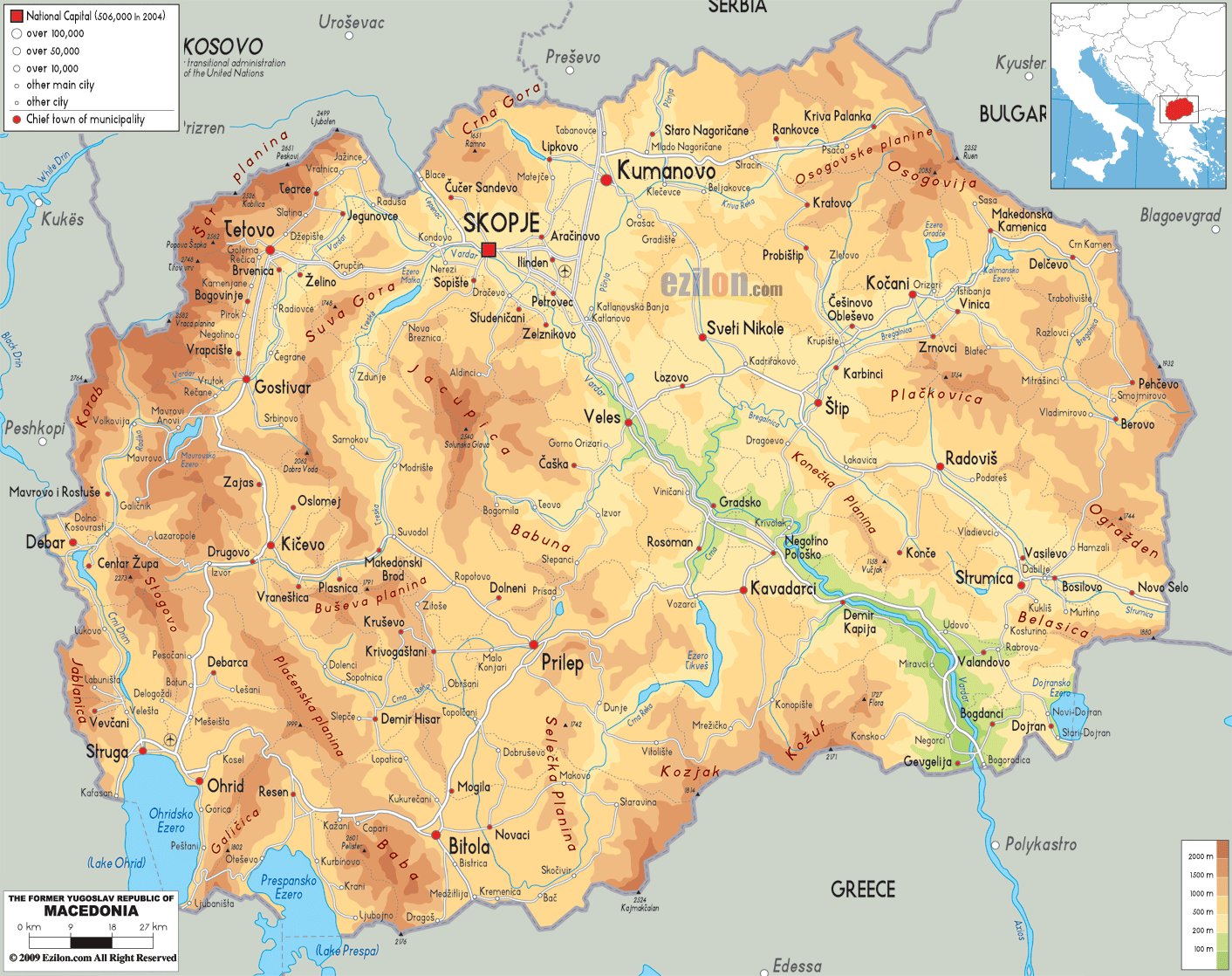
Description: The physical map of Macedonia showing major geographical features like elevations, mountain ranges, lakes, plateaus, peninsulas, rivers, plains, landforms and other topographic features.
This map of Macedonia with mountains, hills, lakes, rivers and other terrains is already large enough to read directly on your desktop. To see a full-screen zoom view on a phone or tablet, tap the map image (or tap the Zoom Map label above the image). Scan by shading municipalities in various colored blocks, with Macedonia's mountains, hills, lakes and rivers in bold.
 Detailed Physical map of North Macedonia showing mountains and lakes, including Lake Ohrid and Lake Prespa, elevations and other topographic features. Macedonia
is a country situated in southwestern Europe. It lies
between north latitude 41.50 degrees and east longitude
22 degrees.
Detailed Physical map of North Macedonia showing mountains and lakes, including Lake Ohrid and Lake Prespa, elevations and other topographic features. Macedonia
is a country situated in southwestern Europe. It lies
between north latitude 41.50 degrees and east longitude
22 degrees.
It is a landlocked country but does have three huge
lakes. They are, Lake Prespa, Lake Ohrid and Lake Dojran.
The total land area of the country is 24856 square
kilometers whereas water additionally covers 857 square
kilometers.
The country can be divided in 4 major zones: Pindus
Mountains mixed forests, Rhodopes mixed forests, Balkans
mixed forests and Aegean mixed forests.
The Vardar River creates a valley in the center of the
country and is bordered by the mountain ranges on both
sides. The mountains creating the valley are the Sar
Mountains and the Osogovo. The three lakes lie towards
the southern border of the country.
The two most dominant mountain ranges in the country are
the Dinaric Range and the Rhodope Range. Mount Korab is
the highest natural peak present in the country and
measure up at 2764 meters. The Sar Mountain is just
behind by a bit and stands tall at 2747 meters.
There are 1100 sources of water in the country which
drain into one of the three dominant basins: Adriatic,
Aegean or Black Sea. River Vardar is the largest river
in the country and the Aegean is the largest basin.

Political Map of Macedonia
Political map and map image of Macedonia.

Road Map of Macedonia
Road map and map image of Macedonia.

Regional Directory of United States of America
Information and guide about United States of America and websites with American topics.

Regional Directory of Europe
Information and guide about Europe and websites with European topics.

Regional Directory of Australia
Information and guide about Australia and websites with Australian topics.
