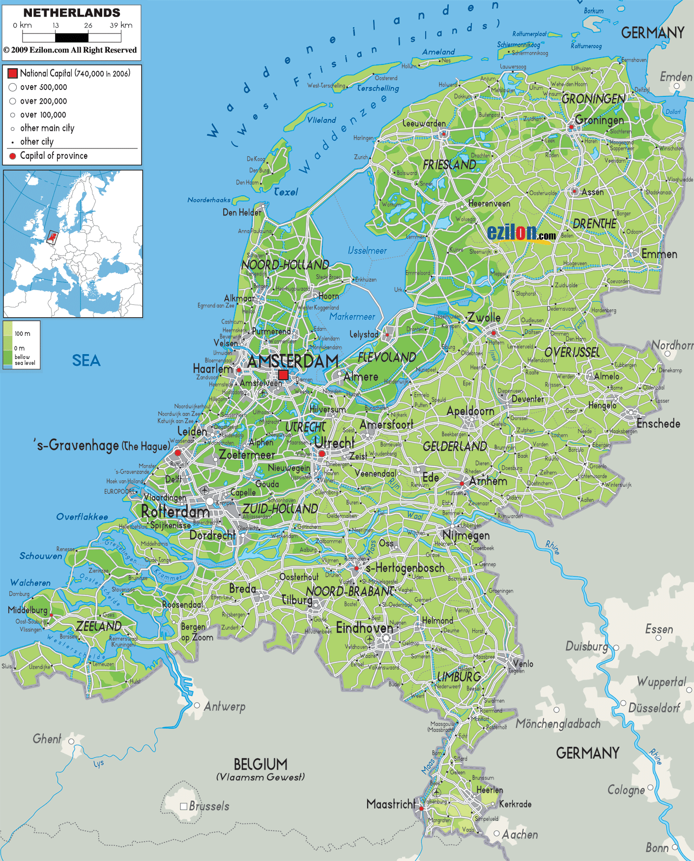
Description: The Physical Map of Netherlands showing major geographical features like elevations, seas, lakes, plateaus, peninsulas, rivers, plains, landforms and other topographic features.
 Looking at the physical map of the Netherlands, one immediately notices a country delicately balanced between water and land. Much of its terrain lies at or even below sea level, necessitating an elaborate system of polders, dykes, and canals. This low-lying country, bordered by the North Sea to the west and northwest, displays a unique topography shaped by centuries of interaction between humans and nature. For geography students and travelers alike, this map is a gateway to understanding the Netherlands’ geographical makeup—from its flatlands to its rivers, from the coastal dunes to reclaimed lands.
The physical map not only shows cities and roads, but overlays them on elevation gradients, rivers, and water bodies. Let's explore the Netherlands inch by inch, focusing on the natural features that define it.
Positioned in northwestern Europe, the Netherlands is a flat country, much of which is painted light green on the map, indicating low elevation. To the north and west lies the North Sea, while Germany borders it to the east and Belgium to the south. Most of the terrain is under 30 meters above sea level. When you look at the coastal edge, particularly in the provinces of Noord-Holland, Zuid-Holland, and Zeeland, you can observe darker green and blue shades indicating regions very close to sea level or reclaimed from the sea.
Looking at the northern edge of the map, above Friesland and Groningen, you'll notice a dotted line of islands extending east to west—these are the West Frisian Islands. Visible names include Texel, Vlieland, Terschelling, Ameland, and Schiermonnikoog. These barrier islands separate the shallow Wadden Sea from the North Sea and act as natural buffers against storm surges. The Wadden Sea, labeled in blue, is a UNESCO World Heritage Site due to its ecological richness and tidal flat system.
These islands and the adjacent sea areas are critical habitats for migratory birds and marine species. From a physical geography standpoint, this entire area is a case study in tidal dynamics and sedimentary landforms.
Coastal Dunes and the North Sea ShorelineRunning along the western edge of the Netherlands, from Zeeland in the south to Noord-Holland in the north, the coastline is punctuated by wide beaches and dunes. On the map, this is the area to the immediate left of cities like The Hague, Haarlem, and Den Helder. The coastal dunes here are the highest natural points in the western Netherlands, acting as primary natural defenses against sea incursion.
In the region of Zuid-Holland, near The Hague and Katwijk, the dunes are particularly well-defined. Behind them lies a narrow zone of coastal plains that were historically marshlands, later drained for agriculture and urban use. The physical geography here is a testament to centuries of water management.
Now glance at the central part of the map, particularly Flevoland and areas north of Amsterdam. The perfectly geometric layout of roads and canals here indicates planned land, known as polders. Flevoland, bordered by the IJsselmeer, is the largest artificial island in the world and consists entirely of reclaimed land.
Key features of Flevoland on the map include:
Lelystad, the capital, located at the center.
Almere, to the southwest, one of the newest and fastest-growing cities.
Grid-like waterways and fields that reflect deliberate planning.
These polders were created by constructing dykes, pumping out water, and controlling the groundwater level with canals and pumps. Their flatness, shown in uninterrupted green tones, reflects the uniform topography typical of engineered landscapes.
To the east of Noord-Holland and surrounding Flevoland, the large blue expanse is the IJsselmeer, formerly part of the Zuiderzee before being enclosed by the Afsluitdijk. This transformation created an enormous freshwater lake, crucial for water management and agriculture.
Below the IJsselmeer, you’ll find the Markermeer—also man-made—separated by a dike and serving both as a reservoir and a buffer for water control. These lakes illustrate how water bodies in the Netherlands are not just natural but often entirely controlled.
One of the most defining features of the Dutch physical map is its river system. Running from east to west, the country’s rivers are the veins of its landscape, facilitating trade, shaping settlement patterns, and creating fertile soils.
Key rivers to observe include:
The Rhine (Rijn): enters from Germany and splits into multiple branches.
The Waal: the main branch of the Rhine, flowing past Nijmegen and Tiel.
The Lek: another branch passing close to Utrecht.
The Meuse (Maas): enters from Belgium, flowing northward through Limburg and then west past cities like Roermond and 's-Hertogenbosch.
The IJssel: branches off the Rhine and flows northward to the IJsselmeer near Kampen.
You can trace these rivers by following the winding blue lines across Gelderland, Limburg, and Overijssel. These are navigable and used heavily for cargo transport.
In the southwest, observe the intricate blue and green pattern of islands and peninsulas—this is Zeeland, a delta province. The Scheldt River splits into multiple estuarine arms before reaching the North Sea. Towns like Middelburg and Vlissingen appear surrounded by water and protected by massive engineering projects.
This area is crucial to understanding Dutch flood control history, particularly the Delta Works, an extensive system of dams, sluices, locks, and storm surge barriers designed after the catastrophic flood of 1953. These works are visible around the Oosterschelde and Westerschelde, the latter being a major shipping route to Antwerp.
While most of the Netherlands is flat, the southeastern region of Limburg presents the country’s only hills and upland terrain. Looking at the map around Maastricht, you’ll notice a more irregular pattern of roads and terrain.
This region includes:
The Vaalserberg, the highest point in the country at 322.7 meters.
Hilly ridges around Vaals and Epen.
Forested zones that differ markedly from the open polders of the north.
These elevated zones are not only scenic but also significant for understanding Dutch geology and soil diversity.
Scattered throughout the map, particularly in Veluwe (central Gelderland), you’ll spot darker green patches indicating forested areas and national parks. The Veluwe is the largest forested area in the Netherlands and includes rolling heaths and sand drifts.
Other notable green zones include:
Utrechtse Heuvelrug
Drentsche Aa National Landscape
Biesbosch National Park (on the delta lands)
These areas support biodiversity and serve as recreational zones. For geography students, they show how land use balances ecology with population density.
Apart from IJsselmeer and Markermeer, smaller lakes dot the Dutch map. Look at Friesland to see clusters of blue areas around Heerenveen and Sneek. These lakes are glacial remnants and serve both tourism and water regulation functions.
Important lakes:
Tjeukemeer in Friesland
Veluwemeer along the Gelderland-Flevoland border
Loosdrechtse Plassen near Utrecht
These are often connected by canals, allowing for extended boat navigation across provinces.
Human Impact on the Physical Landscape
What makes the Netherlands particularly fascinating is how much of its physical geography is human-altered. The map you are viewing is not just natural; it reflects centuries of engineering:
Dykes and levees surround most low-lying areas.
Windmills (historically) and pumping stations (today) maintain water levels.
Entire cities and agricultural regions exist on reclaimed seabeds.
This co-engineering of land and water is visible everywhere—from the straight canals in Flevoland to the ring-shaped city layout of Amsterdam.
Let’s quickly summarise each province’s dominant physical features based on the map:
Groningen:
Low elevation
Coastal marshlands and flat polder terrain
Friesland:
Lakes, islands, and pasturelands
West Frisian Islands
Drenthe:
Sandy soils and heathlands
Forested zones in central areas
Overijssel:
Eastern hills, western floodplains
River IJssel
Gelderland:
Veluwe forests
Rhine and Waal rivers
Utrecht:
Rolling moraine landscapes
Urban-rural mixture
Noord-Holland:
Coastal dunes and reclaimed lands
Surrounded by lakes and canals
Zuid-Holland:
Flat alluvial plains
Urbanized coastlines
Zeeland:
Deltaic islands
Sea-encroached lowlands
Noord-Brabant:
Flat farmland
Sandy soils
Limburg:
Hilly and upland
Meuse valley
Flevoland:
Entirely reclaimed
Geometrically organized polders
For students, this map is a practical tool to learn about the interplay of topography, water, human impact, and natural features. You can see how rivers shape settlements, how lakes affect urban planning, and how even forests are deliberately managed.
For travelers, understanding the physical geography makes every trip richer:
Navigating coastal dunes on a bike
Sailing through interconnected lakes
Hiking in Limburg’s hills
Final Reflection: The Map as a Living Landscape
The physical map of the Netherlands is not static—it’s a living reflection of centuries of transformation. It shows that even the flattest of lands can be complex, vibrant, and full of stories. Whether you’re tracing the line of a river or examining the edge of a reclaimed polder, remember that every inch of this country has been shaped by the ever-evolving relationship between land, water, and people.
All of the rivers in the country drain themselves into the Ijsselmeer Lake which further drains into the North Sea.
The Rhine is a river shared by many countries it originates in Switzerland but eventually empties itself into the North Sea via Netherlands. The Rhine River is also the longest in the country, flowing for 1233 kilometers.

Political Map of Netherlands
Political map and map image of Netherlands.

Road Map of Netherlands
Road map and map image of Netherlands.

Regional Directory of United States of America
Information and guide about United States of America and websites with American topics.

Regional Directory of Europe
Information and guide about Europe and websites with European topics.

Regional Directory of Australia
Information and guide about Australia and websites with Australian topics.