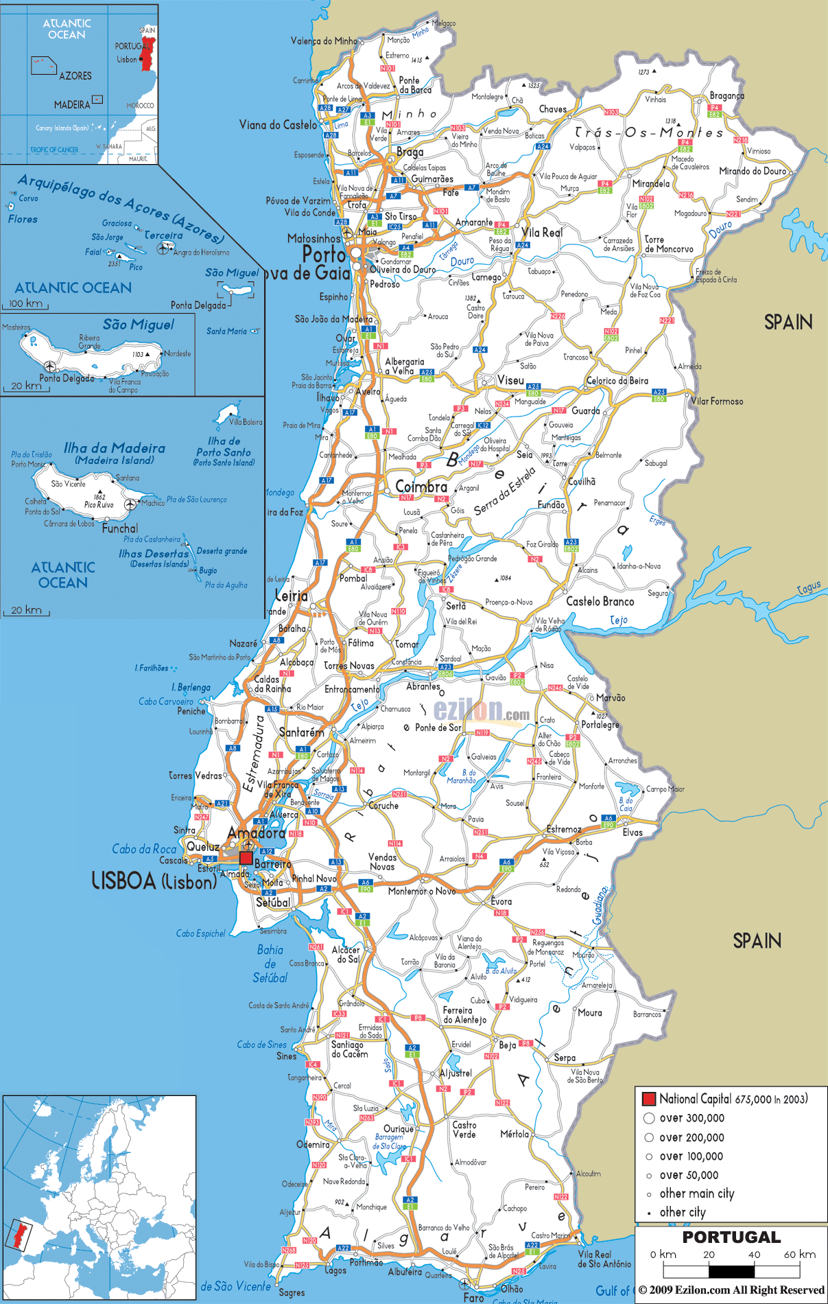
Description: Detailed clear large road map of Portugal with road routes from cities to towns, road intersections / exit roads in regions, provinces, prefectures, also with routes leading to neighboring countries.
This map of Portugal with highways, expressways, and roads is already large enough to read directly on your desktop. To see a full-screen zoom view on a phone or tablet, tap the map image (or tap the Zoom Map label above the image). Scan by shading districts in various colored blocks, with Portugal's highways and expressways in bold.
 Detailed map of Portugal with Road Map of Portugal with Highways and Expressways connecting cities, towns and villages across the country and to the border with Spain. Portugal has roads connecting to cities, towns and villages around the country. Most of its most important roads are concentrated in the South Western coastal cities and towns. Car drivers in Portugal drive on the right and overtake in the left as standard country procedure.
Roads in North Portugal A28 National highway from Valença do Minho connects Viana do Castelo, Esposende, Estela, Póvoa de Varzim, then to Villa do Condo, Matosinhos while joining A17 at cities of Vila Nova de Gaia and Porto.Other notable roads in the North are N101, N103, A24, Az Ip4 E82 connecting cities and towns such as Ponte da Barca, Braga, Guimarães, Chaves, Bragança through Mirandela to Villa Real.
Central Roads A1 E1 one of the longest highway connects São João da Madeira and has an intersection with A25 E80 connecting town of Albergaria-a-Velha, Viseu, Celorico da Beira all the way to Villa Formoso in Eastern border with Spain. IP3 Road connects Tondelo with Santa Comba Dão to the city of Coimbra, this road intersects with other roads like N17 that connects Coimbra with Celorio da Beira. N234 highway also connects Nelas with Carregal do Sal a municipality in Viseu District. A18 from Leira is another principal road in central Portugal connecting city of Leira with Nazaré town, Caldas da Rainha, Toreres Vedras to city of Amadora and the capital city of Lisboa (Lisbon).
South Roads A2 Highway from Almada near the capital city of Lisboa (Lisbon), passed Setúbal city were the road intersect with A6 E90 a road passing Montemor o Novo to Estremoz and Elvas in the East, but A2 E1 goes southwards while passing through the outskirt of Alcácer do Sal to teh region of Algarve in the South. A22 is a major coastal highway in the south connecting Lagos, Portimão, Albufeira, São Brás de Alportel, Faro and Vila Real de Santo António city in the south eastern border.

Political Map of Portugal
Political map and map image of Portugal.

Political Map of Portugal
Political map and map image of Portugal.

Regional Directory of United States of America
Information and guide about United States of America and websites with American topics.

Regional Directory of Europe
Information and guide about Europe and websites with European topics.

Regional Directory of Australia
Information and guide about Australia and websites with Australian topics.