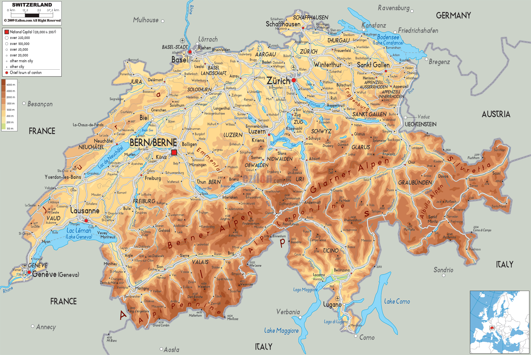
Description: The physical map of Switzerland showing major geographical features like elevations, mountain ranges, seas, lakes, plateaus, peninsulas, rivers, plains, landforms and other topographic features.
 Switzerland may be small, but it is physically extremely varied. This European country has everything to take you away, like tall mountains, deep valleys, beautiful lakes, wide plateaus, and all the rivers. When you go through this guide on the geography of Switzerland, which has been shown with the help of the physical map attached, you will go region-wise, through its topography and natural wonders. If you’re studying geography or are just a keen traveler, this piece is useful for learning more about the land and how it influences Swiss life.
You'll find Geneva (Genève), where Lake Geneva (Lac Léman) meets the Rhône River, in the southwestern tip of the map. A lake shaded light blue occupies most of the region and serves as a glorious natural entrance into the country. Geneva lies at an elevation of roughly 375 metres and is surrounded by low-lying hills. As you follow the Rhône River westward, you can see how the terrain gently slopes, perfect for vineyards and lakeside towns such as Nyon and Montreux.
To the northwest, stretching along the border with France, lies the Jura Mountain range. In these mountains, the colors vary from light brown to dark beige, indicating height. The Jura Plateau contains rolling hillocks, thick forested area and karst features. This area is not as high as the Alps, but it has some striking ridges and valleys, particularly around Delémont which is located in the Jura, and around La-Chaux-de-Fonds located in the Neuchâtel Canton.
The Swiss Plateau is in the centre of the map, and it appears in pale yellow. It extends westward to Lausanne and Bern, northeast to Zürich and St. Gallen. The most populated and intense agricultural area of Switzerland is this area. Major cities such as Bern, Zürich, and Lucerne (Luzern) sit here. The region has hills, meadows, and valleys made by three rivers: Aare, Reuss, and Limmat. The land gradually rises as you head southward.
South of Lucerne, the terrain becomes increasingly rugged. Cantons like Nidwalden, Obwalden, and Uri show a sharp contrast in elevation. The terrain shifts dramatically, with valleys narrowing and mountain ridges climbing into the higher altitudes of the Alps. Rivers such as the Reuss carve through the rock to create deep gorges and alpine passes.
Stretching through the southern portion of Bern and into Valais, the Bernese Alps are marked in rich brown tones. Here you'll find the famous Jungfrau region, as well as peaks such as the Eiger, Mönch, and Jungfrau—all rising above 4,000 meters. The elevation shading on the map helps you visualize the dramatic change from valley towns like Interlaken and Grindelwald to the high-altitude terrain of the surrounding peaks.
Glaciers are prevalent in this area. The Aletsch Glacier—the longest in the Alps—originates from this region. The Rhône River, which flows into Lake Geneva, also begins in this alpine area.
To the southwest, the canton of Valais contains the Pennine Alps, which include some of Switzerland's highest peaks. The Matterhorn, located near Zermatt and the Italian border, towers at 4,478 meters and is one of the most iconic mountains in the world. On the map, you can clearly see how the terrain rises sharply in this region, with towns and villages situated in narrow, steep-sided valleys.
The Rhône River continues through Valais, defining the deep valley that cuts east to west. The corridor where the towns Sion, Sierre, and Martigny are located, is the valley of a river with high mountains
Moving eastward, the Lepontine Alps extend across parts of Ticino and Uri. The Glarus Alps lie to the northeast, in the canton of Glarus. Tödi and Ringelspitz are two of the most beautiful mountains in the area that do not get as many visitors. The glacial valley route of the Linth and the Reuss river, through inaccessible places.
In this area of the map, the valleys usually cross one another. This indicates that the area has seen considerable folding and faulting.
South of the main alpine ridge, Ticino is a region of striking contrast. The southern Alps play a huge role in shaping the ground as large mountain sides drop into low nutrient valleys and large lakes. The map shows the canton's major lakes - Lago Maggiore and Lago di Lugano - which are shaded in blue.
The cities of Lugano, Locarno, and Bellinzona are situated on flatter areas between the lakes and mountains, offering breathtaking backdrops and subtropical vegetation. You can see from the terrain lines how quickly elevation increases outside these urban areas, leading up into the alpine passes that connect Ticino to central Switzerland.
Routes like the Gotthard Pass and San Bernardino Pass (often used by travelers crossing Switzerland north to south) traverse some of the most rugged terrain in the country. These passes are etched into the terrain with snaking lines representing roads or highways winding through the mountain valleys.
On the far eastern edge of the map, Graubünden is the largest and most mountainous canton. This region features the Albula, Silvretta, and Rätikon mountain ranges. The terrain is marked with deep valleys, steep ridgelines, and isolated highlands. The towns of Davos, St. Moritz, and Chur (the capital) are situated in high valleys or at the convergence of river systems like the Rhine.
The brown color dominating this region on the map reflects its predominantly high elevation. Peaks like Piz Bernina (4,049 meters) and Piz Kesch stand as some of the highest in the eastern Alps. The map's detail allows viewers to notice the branching valleys and sparse population centers.
North of the Swiss Plateau lies the gently rolling terrain of northern Switzerland, bordering Germany. This region is marked by river basins, primarily the Rhine River, which flows along the northern border. The map shows how cities such as Basel, Schaffhausen, and Winterthur sit along these water systems.
The Rhine Falls, near Schaffhausen, is the largest waterfall in Europe and is formed by the sudden drop in elevation along this river. The natural scenery of the region is less far-reaching than the Alps but has some hills and forest.
In the northeastern corner, Lake Constance (Bodensee) borders Germany and Austria. It's clearly outlined in the map and serves as a natural boundary. The canton of Thurgau slopes gently toward this lake, offering scenic views and fertile agricultural land.
Switzerland's lakes are clearly visible and serve as geographic anchors in nearly every region:
Lake Geneva (Lac Léman): Shared with France, this is the largest lake in Switzerland, located in the west.
Lake Neuchâtel: Lies between Neuchâtel and Vaud, surrounded by the Jura Plateau.
Lake Lucerne (Vierwaldstättersee): Shaped like an intricate cross, this lake sits amid dramatic alpine terrain.
Lake Zurich: Found in the northeast, near the city of Zürich.
Lake Maggiore and Lake Lugano: Southern lakes with Mediterranean influence, located in Ticino.
Lake Constance (Bodensee): Shared with Germany and Austria.
The light blues represent shallow waters like lakes while the deeper shades of blue represent deeper waters like the oceans. Also, it is dissimilar to the shading of fields and woods. Thus, they are an integral part of the Swiss terrain.
The physical map of Switzerland is more than a display of topography—it's a window into the country's soul. Settlement patterns, language and transportation, have been influenced by every river, mountain, valley and lake. Having detailed elevation contours as well as color shading enables the student or traveller to appreciate the height of the Matterhorn and the shores of Lake Geneva.
When looking at the map, not only will you be informed as to geography, but also other essential aspects of the personality of Switzerland. Whether it is the mountains or the valley floor, every inch in this land tells a story. One can take the word of a geologist that these stories have been inscribed in stone, water, and mountain air.

Political Map of Switzerland
Political map and map image of Switzerland.

Road Map of Switzerland
Road map and map image of Switzerland.

Regional Directory of United States of America
Information and guide about United States of America and websites with American topics.

Regional Directory of Europe
Information and guide about Europe and websites with European topics.

Regional Directory of Australia
Information and guide about Australia and websites with Australian topics.