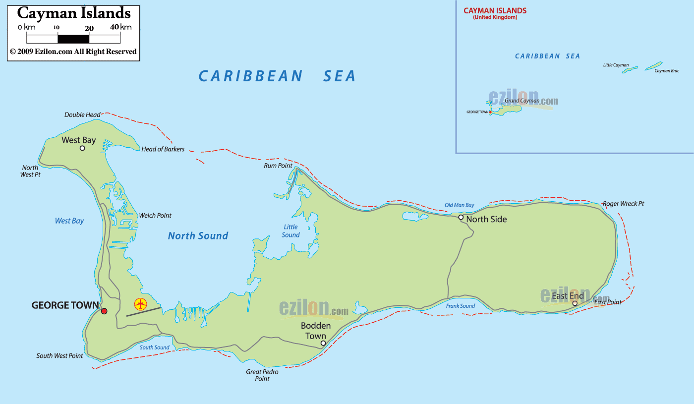
Description: Detailed large political map of Cayman Islands showing names of capital city, towns, districts and boundaries with neighbouring countries.
 Map of Cayman Islands, Cayman Islands map with cities, major towns, districts, and road network. This guide reads the labels exactly as they appear, so visitors, residents, and geography students can find places quickly. The main frame shows Grand Cayman in full, with the capital, George Town, on the west side. The inset at upper right places the Sister Islands of Cayman Brac and Little Cayman east of Grand Cayman in the Caribbean Sea. Red road-light lines sketch the principal corridors that connect districts and bays.
Water bodies. The broad lagoon north of the island is North Sound, with a smaller pocket labeled Little Sound. The south fringe reads South Sound. The entire shoreline sits in the Caribbean Sea.
Districts and towns. From west to east, the labels show West Bay, George Town as the capital, Bodden Town, North Side, and East End.
Coastal reference points. Around the rim, you will see North West Pt, Welch Point, Head of Barkers, Rum Point, Old Man Bay, Roger Wreck Pt, East Point, Great Pedro Point, and South West Point.
Status. British Overseas Territory.
Capital. George Town, Grand Cayman.
Official language. English.
Currency. The Cayman Islands dollar is widely accepted in the US dollar.
Time zone. Eastern Time, without daylight saving time alignment, most years.
Driving. Left side of the road.
Air gateways. Owen Roberts International Airport on Grand Cayman. Inter-island flights connect to Little Cayman and Cayman Brac.
Electricity. 120 V, 60 Hz, plugs Type A and B.
Climate. Tropical marine. Drier period late winter to spring. Hurricane season commonly runs from June to November.
On-water care. Shallow banks and coral heads ring North Sound and South Sound. Use charts and local guidance when boating from Rum Point, Old Man Bay, or East End.
At the northwest corner, the label West Bay marks a settled district that wraps the shoreline from North West Pt down past canal estates shown by tight blue channels. The inner shore faces West Bay water inside the larger North Sound. A road-light corridor runs south from West Bay toward the capital along the most developed coast.
Just below West Bay, the map prints GEORGE TOWN in bold on the west coast. This is the capital and main port. A small airfield symbol sits immediately south of the label, and the coastal road-light line continues through downtown before bending east across the island.
From West Bay, the north coast curves past Head of Barkers toward the tip at Rum Point. The shoreline here defines the northern rim of North Sound. The map shows short road-light spurs that reach beaches and jetties along this arc.
East of Rum Point, the label North Side appears inland with a coastal caption at Old Man Bay. This pair helps you place the district’s village area on a north-facing coast that opens directly to the Caribbean. A minor interior road-light line branches south toward the central highland and back to the coast.
At the far east, the district name East End sits above two sharp coastal markers. Roger Wreck Pt faces northeast while East Point lies on the southeast corner. Their paired labels make a precise eastern reference when you track sea conditions around the tip.
Turning the corner to the south coast, the following bold caption is Frank Sound. The red road-light spine links the east with the central and western districts by crossing the island near this label. Just offshore, the open Caribbean provides calm lee days and windward days; you can read from wave arrows on nautical copies of the map.
Midway along the south edge, the historic label Bodden Town marks the settlement that once served as the early capital. East of it, the rocky headland, Great Pedro Point, projects into the sea. The main road-light line threads Bodden Town and continues west toward the capital.
West of Bodden Town, the water of South Sound describes the shallow inner bay south of George Town. The road-light corridor hugs this shore, then bends north into the capital’s grid. Farther west, the rim closes near South West Point.
The small frame at upper right prints all three main islands under the heading CAYMAN ISLANDS with the note United Kingdom. It shows Grand Cayman to the west and two outliers to the east, labeled Little Cayman and Cayman Brac. Specific towns on the Sister Islands are not printed in this edition, so you can rely on the island names themselves for basic orientation when planning inter-island travel.
Capital and hub: George Town on Grand Cayman.
Districts: West Bay, Bodden Town, North Side, East End.
Major water bodies: North Sound, Little Sound, South Sound, Caribbean Sea.
North shore features: Head of Barkers, Rum Point, Old Man Bay.
East and south features: Roger Wreck Pt, East Point, Frank Sound, Great Pedro Point.
Corner points: North West Pt, South West Point, plus Welch Point on the North Sound rim.
West coast spine. From West Bay to George Town along the most urban strip.
North Sound rim. Short branches from the spine run out to Head of Barkers and Rum Point.
Trans-island link. From East End through Frank Sound to Bodden Town, then onward to George Town.
South return. A continuous line ties Great Pedro Point to South Sound and closes the loop at South West Point.
The Cayman Islands have no land borders. All edges meet the Caribbean Sea. The map focuses on internal districts and coastal markers rather than external neighbors, so the most precise boundary reading is the island shoreline itself.
Start in George Town and trace the west coastal spine to West Bay. Circle the North Sound rim to Head of Barkers and Rum Point for beaches and boat ramps. Cross through Frank Sound to reach East End and the windward shore near Roger Wreck Pt. Follow the south return past Great Pedro Point into Bodden Town and South Sound, then back to the capital. Use the inset to place Little Cayman and Cayman Brac for side trips.

Regional Directory of Caribbean
Information and guide about Caribbean and website listing.

Regional Directory of Canada
Information and guide about Canada and website listing.

Regional Directory of United States of America
Information and guide about United States of America and websites with American topics.

Regional Directory of Europe
Information and guide about Europe and websites with European topics.

Regional Directory of Australia
Information and guide about Australia and websites with Australian topics.