Description: Detailed clear large map of Guadeloupe showing names of capital cities, towns, states, provinces and boundaries with neighbouring countries.
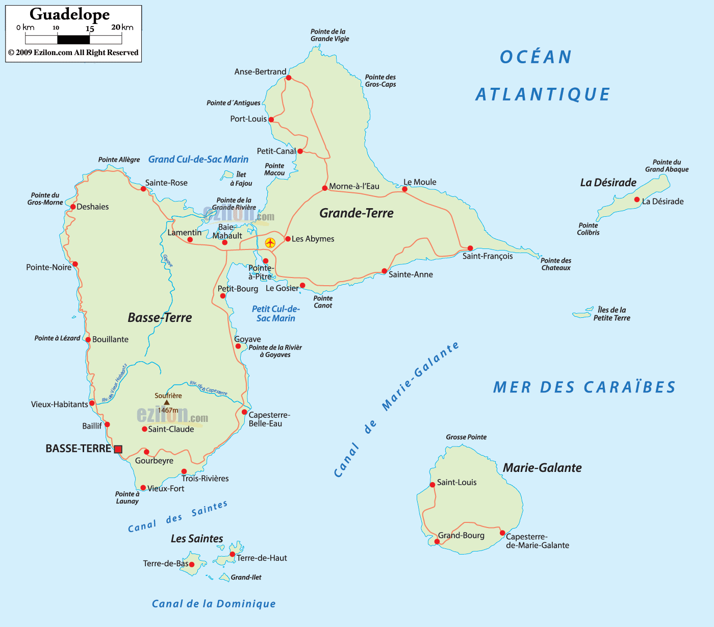
 Map of Guadeloupe, Guadeloupe map with cities, major cities, communes and roads network. This friendly guide shows you how to read the archipelago at a glance. You will see the twin main islands Basse-Terre and Grande-Terre, the outlying islands Marie-Galante, La Désirade, Les Saintes, and Îles de la Petite-Terre, the national capital Basse-Terre city, the main hub Pointe-à-Pitre, the beaches and headlands on the Caribbean Sea and Atlantic Ocean, and the simple road-light corridors that connect towns.
Guadeloupe is a French Caribbean region. The map shows two main islands shaped like a butterfly. Basse-Terre sits on the west. Grande-Terre sits on the east. Between them is a sea inlet labeled Grand Cul-de-Sac Marin to the north and Petit Cul-de-Sac Marin to the south. Bridges and causeways link the two halves near Pointe-à-Pitre and Baie-Mahault. The Caribbean Sea borders the west and south. The Atlantic Ocean borders the north and east.
Status: French overseas region and department in the Caribbean.
Capital: Basse-Terre city on the island of the same name.
Main hub: Pointe-à-Pitre on Grande-Terre with Les Abymes airport.
Language: French is official, Creole is widely spoken.
Currency: Euro.
Time: Atlantic Standard Time, no daylight saving.
Driving: Right side, metric signs.
Ports and ferries: Ferries link Pointe-à-Pitre with Marie-Galante, La Désirade, and Les Saintes.
Quick map tip: Think of the two main islands as a butterfly. The left wing is mountainous Basse-Terre, the right wing is flatter Grande-Terre. The body of the butterfly is Pointe-à-Pitre.
The red square marks Basse-Terre, the capital, on the south-west shore of the island named Basse-Terre. Just inland the map marks Soufrière volcano at 1467 meters, the high point of the archipelago. Nearby towns are Saint-Claude on the slope, Gourbeyre on the bay, and Baillif to the north. At the southern tip you see Vieux-Fort and the point called Pointe à Launay. The channel labeled Canal des Saintes separates this tip from Les Saintes.
Moving north along the Caribbean side you meet Vieux-Habitants, Bouillante, Pointe-Noire, and Deshaies. These labels help you track the curve of the west coast, known for calm water and beaches.
The ring road turns east past Sainte-Rose and Lamentin toward Baie-Mahault. The sea label Grand Cul-de-Sac Marin marks the mangrove lagoon that divides the two big islands. A bridge crosses here toward Grande-Terre.
Pointe-à-Pitre sits at the narrow channel between the islands. The airport symbol marks Pôle Caraïbes Airport near Les Abymes. South of the center the map shows Le Gosier on the hotel coast. The main roads spread like a fan to both islands, so this is your map’s traffic hub.
From Pointe-à-Pitre a coastal road passes Le Gosier, then Sainte-Anne, then Saint-François at the far end. A thin point called Pointe des Châteaux sticks into the Atlantic. This is the south beach belt of Grande-Terre.
Turning north from Saint-François you reach Le Moule. Farther along are Morne-à-l’Eau inland, Petit-Canal on the inner shore, then Port-Louis and Anse-Bertrand near Pointe de la Grande Vigie at the very top. Labels like Pointe des Gros-Caps and Pointe d’Antigues show the windy Atlantic edge.
The road bends west to Baie-Mahault and the bridge area. On the water you see the small Îlet à Fajou inside the Grand Cul-de-Sac Marin. Cross the causeway and you are back at Pointe-à-Pitre.
A long narrow label marks La Désirade east of Grande-Terre. The main village is La Désirade. Headlands like Pointe du Grand Abaque and Pointe Colibris fix the island on the Atlantic side.
South-east of the main pair sits round Marie-Galante. The map marks Grand-Bourg, Saint-Louis, and Capesterre-de-Marie-Galante. The north label Grosse Pointe helps you set the top of the island. The channel is named Canal de Marie-Galante.
South of Basse-Terre you see Les Saintes. The two main islands are Terre-de-Haut and Terre-de-Bas, joined by ferry lines. The label Canal de la Dominique at the far south points toward the neighbor country Dominica.
Between Grande-Terre and La Désirade the small Îles de la Petite-Terre sit inside bright blue water. They are tiny on the map but the label helps you place this protected area.
Ring of Basse-Terre. A coastal loop links Basse-Terre, Vieux-Fort, Bouillante, Pointe-Noire, Deshaies, Sainte-Rose, Lamentin, and Baie-Mahault.
Ring of Grande-Terre. A loop from Pointe-à-Pitre runs through Le Gosier, Sainte-Anne, Saint-François, Le Moule, Port-Louis, Anse-Bertrand, and back to Baie-Mahault.
Cross connections. Short spurs link Morne-à-l’Eau with the inner lagoon, and Petit-Bourg with Goyave and Capesterre-Belle-Eau on the Basse-Terre side.
Guadeloupe has only sea borders. The Caribbean Sea lies to the west and south. The Atlantic Ocean lies to the north and east. The nearest neighbors by water are Dominica to the south across the Canal de la Dominique, Antigua and Barbuda to the north-east, and Montserrat to the north-west.
Basse-Terre (capital), Saint-Claude, Gourbeyre, Baillif, Vieux-Fort, Vieux-Habitants, Bouillante, Pointe-Noire, Deshaies, Sainte-Rose, Lamentin, Petit-Bourg, Goyave, Capesterre-Belle-Eau, Trois-Rivières.
Pointe-à-Pitre, Les Abymes, Le Gosier, Sainte-Anne, Saint-François, Le Moule, Morne-à-l’Eau, Petit-Canal, Port-Louis, Anse-Bertrand, Baie-Mahault.
Grand-Bourg, Saint-Louis, Capesterre-de-Marie-Galante on Marie-Galante. La Désirade village on La Désirade. Terre-de-Haut, Terre-de-Bas in Les Saintes.

Regional Directory of Caribbean
Information and guide about Caribbean and website listing.

Regional Directory of Canada
Information and guide about Canada and website listing.

Regional Directory of United States of America
Information and guide about United States of America and websites with American topics.

Regional Directory of Europe
Information and guide about Europe and websites with European topics.

Regional Directory of Australia
Information and guide about Australia and websites with Australian topics.