Description: Detailed large political map of Martinique showing names of capital city, cities, islands, towns, states, provinces and boundaries with neighbouring countries.
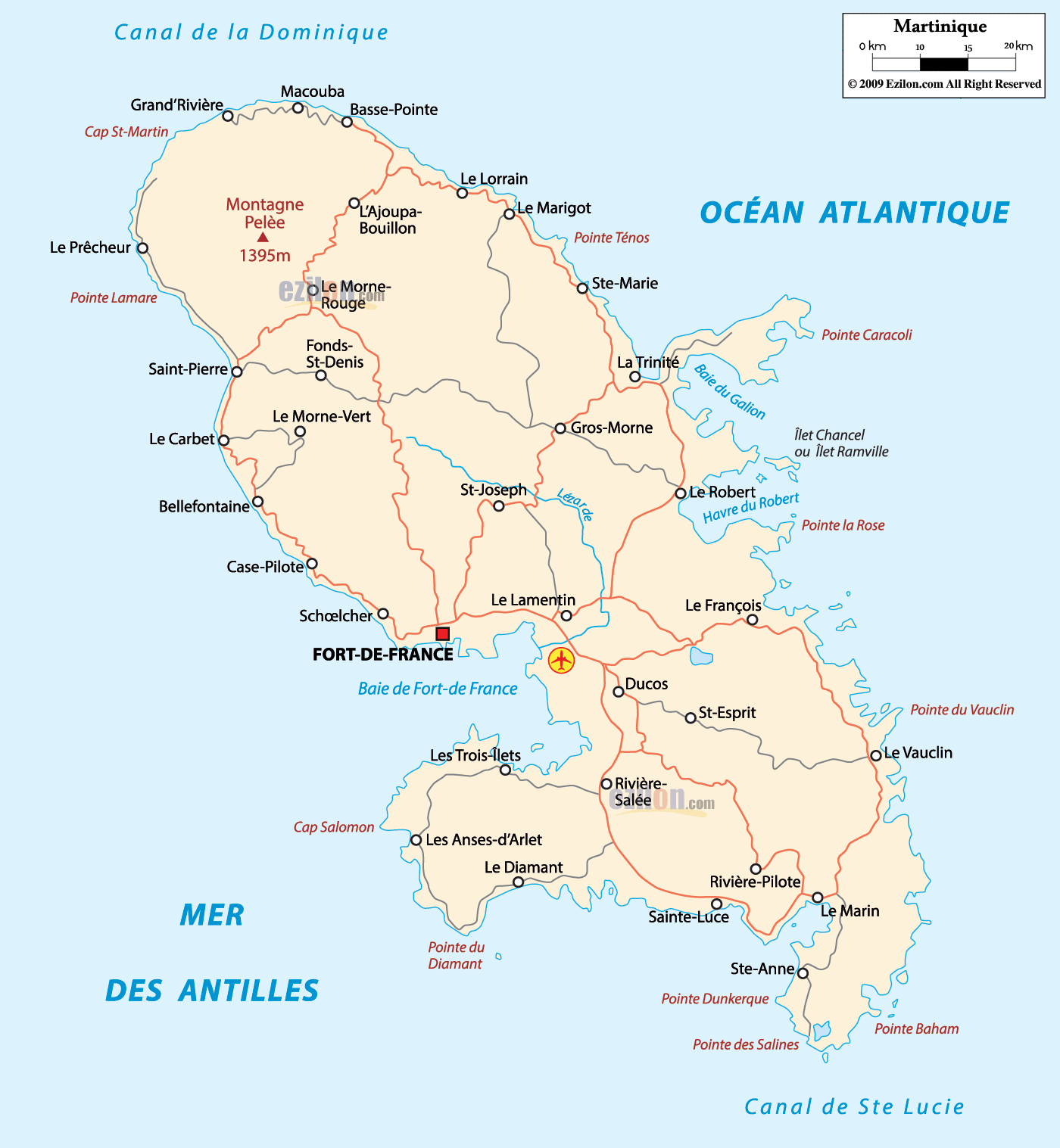
 Map of Martinique, featuring cities, major cities, communes, and the road network. Use this detailed map as a simple guide to find places fast. You can see the island’s capital, many towns, the lines of the main roads, bays, capes, and the water that surrounds the island. Martinique is a French overseas department in the Lesser Antilles. The Caribbean Sea is on the west coast. The Atlantic Ocean is on the east coast. The island sits between two neighbors that matter for orientation. Dominica is to the north across the Canal de la Dominique. Saint Lucia is to the south across the Canal de Ste Lucie.
Capitals and big towns use larger labels.
Thin red lines show the main road-light corridors that link towns.
Blue labels mark bays and rivers.
Small black dots mark communes and villages.
Green shading in the northwest marks Montagne Pelée and northern forests.
Martinique Aimé Césaire International Airport is near Le Lamentin, just east of Fort-de-France.
Ferries run across the bay between Fort-de-France and Les Trois-Îlets and connect to nearby islands on regional routes.
Main marinas and ports are Fort-de-France, Le Marin, and Saint-Pierre.
Language: French is the official language; Martinican Creole is widely spoken.
Currency: Euro (EUR).
Time zone: UTC minus 4 hours all year. No daylight saving.
Driving: right-hand side, speed limits in km/h, seat belts required.
Power: 230 V, 50 Hz, plug types C and E.
Calling code: +596.
Internet: Fast mobile data is widely available in towns.
Emergency: 112 works; fire 18, medical 15, police 17, sea rescue 196.
Tropical climate with a dry season roughly from December to May and a rainy season from June to November. Hurricane season peaks from August to October. Check local forecasts and follow official guidance near Mont Pelée and on coastal hikes.
Montagne Pelée sits in the far north. The map lists its height as 1395 m. It is the highest point on the island and an easy landmark. Around it are several communes that form a ring of settlements.
On the northwest coast, find Grand’Rivière and Macouba. They face the Canal de la Dominique and the open Atlantic.
Sliding a bit south along the same coast, you meet Basse-Pointe and Le Carbet.
West of the volcano sit Saint-Pierre, Le Prêcheur, Le Morne-Rouge, Le Morne-Vert, Fonds-Saint-Denis, Case-Pilote, and Bellefontaine. This cluster shows how many people live on the safer slopes and near the sea.
On the northeast coast, you will see L’Ajoupa-Bouillon, Le Lorrain, Le Marigot, and Sainte-Marie. A small red road line links them down the coastline.
Key coastline names in the north
Cap St-Martin marks the far northwest tip.
Pointe Ténos lies on the northeast shore near Le Marigot.
Baie du Galion sits by La Trinité, farther south along the Atlantic.
The island’s center is easy to read on the map because the labels are bigger and the bay outline is broad.
The capital is Fort-de-France, on the west coast facing Baie de Fort-de-France.
Just east of the capital is Le Lamentin, where the main airport sits.
North and west of the capital are Schoelcher, Case-Pilote, and Le Carbet.
Inland and north of the bay are Saint-Joseph and Gros-Morne.
On the Atlantic side across the hills, the central coast shows La Trinité and Le Robert. The label Havre du Robert marks the calm harbor with many islets.
Road-light corridors in the center
A central corridor runs from Fort-de-France through Le Lamentin to Le François on the southeast coast, then to Le Vauclin and down to Le Marin.
Another corridor loops from Fort-de-France north to Schoelcher and Case-Pilote, then back inland toward Saint-Joseph and Gros-Morne, finally dropping to La Trinité on the Atlantic side.
These loops let you cross the island in one to two hours, depending on stops and hills.
The southern third of Martinique is a long peninsula that points toward Saint Lucia. Many of the island’s most visited bays and beaches are here.
On the Caribbean coast, moving south from the capital area, you meet Les Trois-Îlets, Les Anses-d’Arlet, and Le Diamant. The label Cap Salomon appears near the Anses-d’Arlet headland.
In the south center, the map names Rivière-Salée, Ducos, and Saint-Esprit. They sit along the east-west inner road that connects both coasts.
On the Atlantic coast, look for Le François, Le Vauclin, Le Marin, Sainte-Luce, and Sainte-Anne. Pointe des Salines, famous for a long white sand beach, marks the very tip of the island.
East of Sainte-Anne, the map adds Pointe Dunkerque and Pointe Baham. These are small caps that help you place the shoreline when you drive along the coast.
Southern harbors and bays
Baie du Robert and the Havre du Robert are full of small islets and shallow turquoise water.
Baie de Fort-de-France is the giant west-coast inlet that shelters the capital.
Le Marin has a deep bay and the island’s biggest marina.
This section helps you scan the map fast. Use it like a reading guide. Every place listed below appears on the map.
Le Prêcheur and Saint-Pierre sit under the volcano on the upper west coast. Saint-Pierre was the old capital and is easily accessible, located just south of Le Prêcheur.
Le Carbet lies a few minutes south by the shore, then Bellefontaine and Case-Pilote line the road toward the bay.
Around the bay’s inner rim, you will see Schoelcher, the capital Fort-de-France, and the resort area of Les Trois-Îlets across the water.
Continuing south, the coast curves past Les Anses-d’Arlet and the tall rock near Le Diamant.
What you can spot from the map: The west coast road is mostly continuous. It hugs the sea from Le Prêcheur all the way to Le Diamant. The red corridor line shows many small inlets where drivers can pull over for views.
Starting at the northeast corner near Grand’Rivière, the coast moves down past Basse-Pointe, Le Lorrain, Le Marigot, and Sainte-Marie.
Midway on the east side are La Trinité and the Baie du Galion. South of that are Le Robert and Havre du Robert with many small islands offshore.
The road then drops toward Le François, Le Vauclin, and Le Marin before wrapping around to Sainte-Anne and Sainte-Luce.
Coastline tips: The east coast has more reefs and cays. The bays are named on the map, which helps when you plan snorkeling or boat trips.
Saint-Joseph, Gros-Morne, and Ducos mark the inland ridges that connect the two coasts.
Le Morne-Rouge, Le Morne-Vert, and Fonds-Saint-Denis are the small mountain communes north of the bay under Montagne Pelée. They are good anchor names when you look for hiking areas.
Fort-de-France is the capital and largest city.
Le Lamentin is just east of the capital and is easy to recognize because many roads meet there.
Schoelcher borders Fort-de-France to the northwest and holds the main university campus area.
North border by sea: the Canal de la Dominique separates Martinique from Dominica. The channel name is printed across the top left corner of the map.
South border by sea: the Canal de Ste Lucie separates Martinique from Saint Lucia. The label runs below the southern peninsula.
West: the Caribbean Sea.
East: the Atlantic Ocean.
These names help you place the island within the Lesser Antilles chain.
North ring. From Fort-de-France to Schoelcher, Case-Pilote, Le Carbet, and Saint-Pierre, with side roads to Le Morne-Rouge and Le Prêcheur.
Cross-island central link. From Fort-de-France through Le Lamentin and Saint-Joseph to Gros-Morne, then down to La Trinité and Le Robert.
Southeast arc. From Le Lamentin to Le François, Le Vauclin, and Le Marin, then west to Sainte-Luce and back toward Rivière-Salée.
Southern beach loop. Les Trois-Îlets to Les Anses-d’Arlet to Le Diamant, then inland to Rivière-Salée and up to the bay.
These lines are not numbered highways on the map, but the red paths make the main travel patterns clear.
North and northwest: Grand’Rivière, Macouba, Basse-Pointe, Le Prêcheur, Saint-Pierre, Le Carbet, Bellefontaine, Case-Pilote. Northern interior: Montagne Pelée, Le Morne-Rouge, Le Morne-Vert, Fonds-Saint-Denis. Northeast and east: L’Ajoupa-Bouillon, Le Lorrain, Le Marigot, Sainte-Marie, La Trinité, Le Robert. Center and capital area: Fort-de-France, Le Lamentin, Schoelcher, Saint-Joseph, Gros-Morne. South and southeast: Le François, Le Vauclin, Ducos, Saint-Esprit, Rivière-Salée, Le Marin, Sainte-Luce, Sainte-Anne. Southwest and Caribbean beaches: Les Trois-Îlets, Les Anses-d’Arlet, Le Diamant.
The northwest is cooler and mountainous because of Montagne Pelée. Towns like Saint-Pierre and Le Morne-Rouge appear close to the green relief.
The capital, the Bay Area, is the busiest. Fort-de-France and Le Lamentin are the best hubs to start any drive.
The east coast from La Trinité to Le Vauclin has many sheltered lagoons like the Havre du Robert that are popular for boat trips to islets.
The south between Le Marin, Sainte-Anne, Sainte-Luce, Les Anses-d’Arlet, and Le Diamant is where most beaches are, linked by the southern loop road.

Regional Directory of Caribbean
Information and guide about Caribbean and website listing.

Regional Directory of Canada
Information and guide about Canada and website listing.

Regional Directory of United States of America
Information and guide about United States of America and websites with American topics.

Regional Directory of Europe
Information and guide about Europe and websites with European topics.

Regional Directory of Australia
Information and guide about Australia and websites with Australian topics.