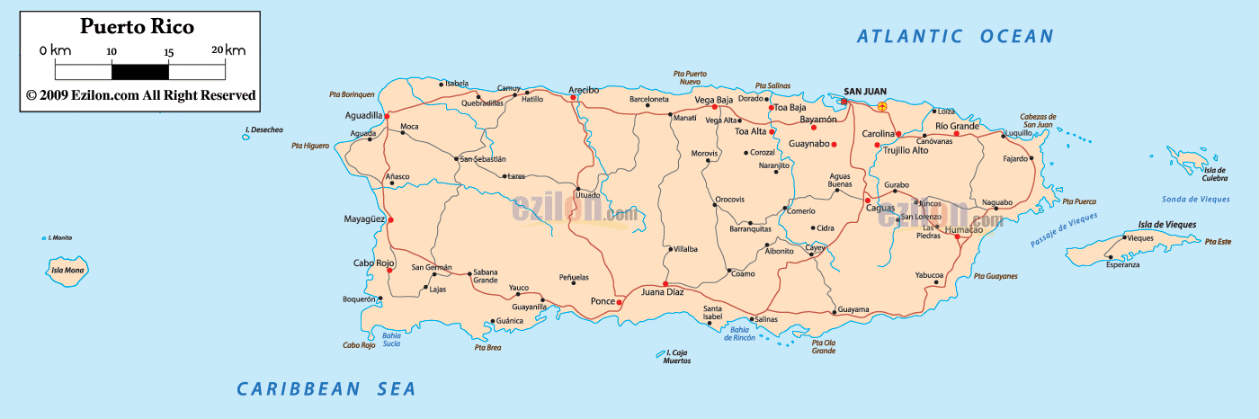
Description: Detailed large political map of Puerto Rico showing names of capital city, cities, islands, towns, states, provinces and boundaries with neighbouring countries.
 Map of Puerto Rico, Puerto Rico map with cities, major municipalities, and a simple road network. This best detailed map helps you locate the capital San Juan, coast-to-coast corridors, and the island municipalities of Vieques and Culebra. Read it like a tour around the island, so students, travelers, and locals can quickly find places.
Puerto Rico is a United States territory in the northeastern Caribbean. The Atlantic Ocean borders the north coast, and the Caribbean Sea borders the south coast. To the West is the Mona Passage toward the Dominican Republic. To the east are the Virgin Islands across the Virgin Passage. Official languages Puerto Rico are Spanish and English, and the currency is the US dollar.
The north shoreline faces the Atlantic Ocean. You will see Arecibo, Manatí, Vega Baja, Dorado, Bayamón, and Carolina along this arc around the San Juan metro.
The south shoreline faces the Caribbean Sea with towns such as Ponce, Guayanilla, Peñuelas, Yauco, Guánica, Guayama, Salinas, Santa Isabel, and Coamo a little inland.
The West showcases surf towns like Rincon and Aguadilla. The east shows the rainforest uplands near El Yunque with Río Grande, Luquillo, Fajardo, Ceiba, Naguabo, and the nearby island municipalities of Vieques and Culebra.
Puerto Rico has 78 municipalities. On the map, municipality seats are denoted by bolder labels. The capital is marked with a red square, and airport symbols mark the main airfields.
Look at the northeast corner, where the map prints San Juan on the Isleta de San Juan. Around it are Bayamón to the West, Guaynabo to the south, Carolina to the east near the main airport, Toa Baja and Toa Alta on the suburban rim, Trujillo Alto along the interior edge, and Loíza on the coastal flats. This is the largest urban area on the island.
Moving west from the capital, you meet Vega Alta, Vega Baja, Manatí, Barceloneta, and Arecibo, which is a major north coast center. Turning east from San Juan, you pass Canóvanas, Río Grande near the foothills of El Yunque, then Luquillo, Fajardo with ferry links, and Ceiba at the old naval base.
The northwest corner shows Aguadilla with the Rafael Hernández Airport. South of it are Moca, Isabela, and Quebradillas. Along the far west coast, you see Aguada and Rincón, a surf capital. A bit inland are Lares and Jayuya in the central highlands.
The south shore touches the Caribbean Sea. The largest city here is Ponce with the Mercedita Airport. West of Ponce are Peñuelas, Guayanilla, Yauco, Guánica, and Cabo Rojo on the southwest cape. East of Ponce, the shoreline runs through Santa Isabel, Salinas, and Guayama near the Las Mareas area. The route continues to Arroyo, Patillas, Maunabo, and Yabucoa as the coast bends north.
The eastern tip contains Humacao, Naguabo, Fajardo, and Ceiba. Off this coast, the map highlights two municipal islands:
Vieques with the capital Isabel Segunda and the airport at Antonio Rivera Rodríguez.
Culebra with Dewey and Benjamín Rivera Noriega Airport. Ferries connect from the Fajardo or Ceiba area.
A north-south backbone called the Cordillera Central crosses the island. Here you can spot Utuado, Adjuntas, Jayuya, Orocovis, Barranquitas, Aibonito, Cidra, Cayey, Ciales, Morovis, Corozal, Comerío, Naranjito, Caguas, Gurabo, Juncos, San Lorenzo, and Las Piedras. These seats connect to the coasts by short valleys where the roads descend into the plains.
North coastal corridor. From San Juan west through Bayamón, Dorado, Vega Baja, Manatí, and Arecibo. This follows the high-capacity route often labeled PR-22 and then PR-2 to the West.
Cross-island expressway. From San Juan south to Caguas, across the mountains by Cayey, then down to Salinas and west to Ponce. On many maps, this is PR-52 and PR-1.
South coastal corridor. From Ponce east through Santa Isabel, Salinas, and Guayama, or West through Peñuelas, Guayanilla, and Yauco toward Cabo Rojo.
East corridor to the ferries. From San Juan toward Río Grande, Luquillo, Fajardo, and Ceiba for boats to Vieques and Culebra.
West loop. From Arecibo around to Aguadilla, Aguada, and Rincón then south to Mayagüez and back toward Ponce.
These are not drawn as numbered highways on every political map, but the red lines show the general corridors that carry most trips.
Atlantic Ocean along the entire north coast.
Caribbean Sea along the south coast.
Mona Passage to the West toward the Dominican Republic.
Virgin Passage to the east toward the US Virgin Islands and the British Virgin Islands.
Official name: Commonwealth of Puerto Rico
Capital: San Juan
Largest southern city: Ponce
Major airports printed: Luis Muñoz Marín near Carolina, Rafael Hernández at Aguadilla, Mercedita at Ponce, plus field airports on Vieques and Culebra
Best use of the map: find the metro cluster around San Juan, follow the north and south corridors, and use the east coast labels to reach ferries to the island municipalities.

Regional Directory of Caribbean
Information and guide about Caribbean and website listing.

Regional Directory of Canada
Information and guide about Canada and website listing.

Regional Directory of United States of America
Information and guide about United States of America and websites with American topics.

Regional Directory of Europe
Information and guide about Europe and websites with European topics.

Regional Directory of Australia
Information and guide about Australia and websites with Australian topics.