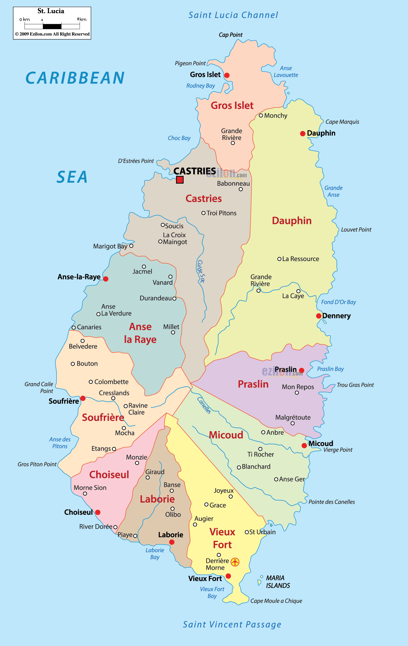
Description: Detailed large map of Saint Lucia showing names of capital city, cities, islands, towns, states, provinces and boundaries with neighbouring countries.
 Map of Saint Lucia, Saint Lucia map with cities, major towns and quarters. This easy guide uses a detailed map to help you find places fast. You will see the best map features for orientation, including quarters, capital symbols, coastlines, and simple road-light corridors that link communities around the island.
A red square marks the national capital Castries on the northwest coast.
Red dots mark other towns such as Gros Islet, Soufrière, Dennery, Micoud, Vieux Fort, Laborie, Choiseul, Anse-la-Raye, Praslin, and hamlets like Babonneau and Monchy.
Quarter names appear in large shaded blocks: Gros Islet, Castries, Anse la Raye, Soufrière, Choiseul, Laborie, Vieux Fort, Micoud, Praslin, Dennery, and Dauphin.
Thin red lines show the island’s main road-light corridors that ring the coast and cross the interior.
West coast faces the Caribbean Sea, with bays like Rodney Bay, Choc Bay, Marigot Bay, Anse des Pitons, Grand Caille Point, and River Dorée. East coast faces the Atlantic Ocean, with Grande Anse, Fond d’Or Bay, Praslin Bay, Vierge Point, Pointe des Canelles, and Cape Moule a Chique near the southern tip. North is the Saint Lucia Channel, the waterway between Saint Lucia and Martinique; look for Cap Point and Pigeon Point. South is the Saint Vincent Passage, the route toward Saint Vincent and the Grenadines; off the tip you will see the Maria Islands by Vieux Fort.
The island’s north end is shaded for Gros Islet. The town of Gros Islet sits just below Pigeon Point and Rodney Bay. The coastline bends past Cap Point and the small cove of Anse Lavoutte. Inland, the map labels Grande Rivière and Monchy, which are two upland communities that connect to the coastal ring road toward Castries.
Just south of Gros Islet you enter Castries Quarter, wrapped around the capital. The red square marks Castries on the sheltered harbor with Choc Bay to the north. Suburbs and villages include Babonneau, Trois Pitons, Soucis, La Croix Maingot, Durandeau, and the scenic inlet of Marigot Bay along the quarter’s western edge. This quarter is the hub where west coast and east coast roads begin.
On the northeast flank the map shows Dauphin, a broad Atlantic section with Monchy on its ridge line and the coastal point of Cape Marquis. Smaller places like La Ressource and Grande Rivière appear in the south of the block as the road turns down toward Dennery. Look for rougher Atlantic coves including Grande Anse and Louvet Point.
Midway on the east coast the shaded block reads Dennery. The fishing town of Dennery sits by Fond d’Or Bay, with nearby communities La Caye, La Ressource, and Grande Rivière. The coastal road-light corridor continues south to Praslin and north to Dauphin.
Between Dennery and Micoud the map sets off Praslin as its own block. Praslin village sits near Praslin Bay. You will also see Mon Repos, Malgretoute, and Anbre. Small inlets and points dot this quieter Atlantic stretch.
South along the Atlantic coast is Micoud. The town of Micoud stands near Vierge Point, with inland communities Ti Rocher, Blanchard, and Anbre at the quarter’s northern edge. The road runs flat and straight here, connecting quickly to Vieux Fort.
At the island’s southern tip the map highlights Vieux Fort with the airport symbol and the town label Vieux Fort beside Vieux Fort Bay. Landmarks include Derrière Morne, St Urbain, and the rocky headland of Cape Moule a Chique. Offshore are the Maria Islands, a small protected pair that sit just east of the tip.
Turning the corner to the Caribbean side, the map shows Laborie tucked between Vieux Fort and Choiseul. The village of Laborie faces Laborie Bay, and nearby hamlets Banse, Olibo, and Augier lie along the linking road.
Northwest of Laborie, Choiseul stretches from Morne Sion down to River Dorée and the seaside town of Choiseul. This is a scenic reach of the west coast where the coastal road-light corridor climbs and descends along cliffs and coves.
North of Choiseul, Soufrière is centered on the town of Soufrière, with the inland label Mocha and coastal places Etangs and Anse des Pitons. The jagged cone icons mark the famous twin peaks, the Pitons, rising right behind the shore. The west coast road continues north toward Anse la Raye.
Continuing up the Caribbean side, Anse la Raye includes the fishing village Anse-la-Raye and communities such as Anse La Verdure, Canaries, Belvedere, Bouton, Colombette, Cresslands, Ravine Claire, Millet, Vanard, and Jacmel. The coastline bends toward Marigot Bay as you approach Castries again.
From Castries the red corridor follows the Caribbean edge through Marigot Bay to Anse-la-Raye, then to Soufrière, Choiseul, Laborie, and into Vieux Fort. This is the scenic shoulder of the island, with lookouts near the Pitons and coves like Grand Caille Point and River Dorée.
From Castries or Babonneau the eastern corridor drops into Dauphin, then follows the Atlantic through Dennery, Praslin, Micoud, and down to Vieux Fort. Expect straighter segments and wide ocean views across Fond d’Or Bay, Praslin Bay, and Vierge Point.
Short spurs link the two coasts. The map shows inland routes near Babonneau and Trois Pitons crossing toward Dennery, and smaller links through Millet and Ti Rocher that connect the west and east networks. These cuts are helpful if you want to circle the island in one day.
North: Gros Islet, Rodney Bay, Pigeon Point, Cap Point.
North-east: Dauphin, Cape Marquis, Grande Anse.
East: Dennery, Fond d’Or Bay, Praslin, Micoud, Vierge Point.
South: Vieux Fort, Cape Moule a Chique, Maria Islands.
West: Laborie, Choiseul, Soufrière, Anse-la-Raye, Marigot Bay, back to Castries.
Capital and symbol: Castries is the capital and is shown with a red square on the northwest harbor.
Largest resort zone: Rodney Bay and Gros Islet at the north tip, easy to spot above Castries.
Iconic landmark: The Pitons stand just south of Soufrière on the west coast.
Airport and southern hub: Vieux Fort with the airport symbol and the Maria Islands just offshore.
Best east coast viewpoint: The bluffs by Dennery and Praslin Bay along the Atlantic.
Best west coast viewpoint: Clifftops between Anse-la-Raye and Soufrière.

Regional Directory of Caribbean
Information and guide about Caribbean and website listing.

Regional Directory of Canada
Information and guide about Canada and website listing.

Regional Directory of United States of America
Information and guide about United States of America and websites with American topics.

Regional Directory of Europe
Information and guide about Europe and websites with European topics.

Regional Directory of Australia
Information and guide about Australia and websites with Australian topics.