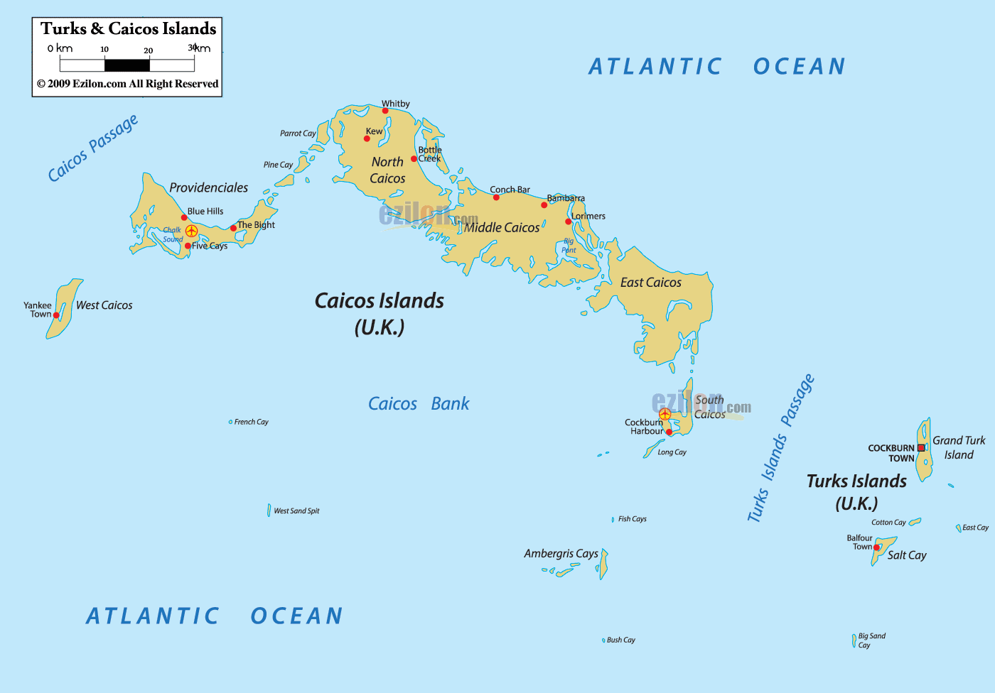
Description: Detailed large political map of Turks and Caicos Islands showing names of capital cities, towns, states, provinces and boundaries with neighbouring countries.
 Map of Turks and Caicos Islands with cities, major towns, and districts. Use this detailed map to read the full crescent of the Caicos Islands from West Caicos and Providenciales across North Caicos, Middle Caicos, East Caicos, and South Caicos, then jump the Turks Islands Passage to the Turks Islands, where Grand Turk with Cockburn Town and Salt Cay with Balfour Town sit on the eastern horizon of the Atlantic Ocean. Labels show settlement names, island outlines, shallow banks, and sea lanes like Caicos Passage, the broad Caicos Bank, and the Turks Islands Passage. What follows mirrors the Canada guide style so residents, visitors, and geography students can find every place quickly.
Water bodies and passages. The west side touches the Caicos Passage. The south is a wide, shallow platform named the Caicos Bank. The channel between both island groups is labeled the Turks Islands Passage. All edges sit in the Atlantic Ocean.
Islands by group. The Caicos Islands, left to right: West Caicos, Providenciales, offshore cays Pine Cay and Parrot Cay, then North Caicos, Middle Caicos, East Caicos, and South Caicos, with Long Cay just off its coast. Turks and Caicos Islands on the right: Grand Turk Island with Cockburn Town, and Salt Cay with Balfour Town, plus small islets Cotton Cay, East Cay, and Big Sand Cay.
Political status: British Overseas Territory named Turks and Caicos Islands.
Capital. Cockburn Town on Grand Turk Island.
Largest travel hub. Providenciales in the Caicos Islands.
Language. English.
Currency. United States dollar (USD).
Time zone. Eastern Time with daylight saving time alignment.
Driving. Left side of the road.
Airports. Providenciales International Airport (PLS) for most international flights; JAGS McCartney International on Grand Turk for inter-island links.
Electrical. 120 V, 60 Hz, plugs Type A and B.
Climate. Tropical marine with a drier season roughly from late winter to spring. Hurricane season typically runs from June to November.
Safety and environment. Reefs and shallows are protected areas in many zones. Use marked moorings and follow local guidance for wildlife and water safety.
At the far west, the rectangular landmass is West Caicos. The name Yankee Town appears on the east shore near the closest crossing to Providenciales. West Caicos is rimmed by reef and faces deep water in the Caicos Passage. Its isolated position makes it a clean west marker when you trace the chain.
Moving east, you arrive at Providenciales. This is the busiest island and the common arrival point. The map prints several neighborhoods that you can use for orientation.
Blue Hills sits on the north coast toward the west end.
The Bight is centered on the long north beach.
Five Cays forms a low peninsula on the southwest.
Chalk Sound is the lagoon area on the south side. A road-light spine runs along the populated side, visible as a single red line with short branches toward beaches and the airport symbol. The island faces the Caicos Bank to the south and the reef line to the north.
Northeast of Providenciales, two low islands are labeled Pine Cay and Parrot Cay. They sit on the shallow rim between Provo and North Caicos and serve as stepping stones for boats and ferries. On the map, they help you track the approach to North Caicos.
Across narrow channels, the land opens into North Caicos. Three labels define its layout.
Whitby lies on the open north coast and fronts a long beach.
Kew rests inland and anchors the farm district.
Bottle Creek traces the deep inlet on the east side. Road-light lines connect these points and curve toward the crossing into Middle Caicos.
The largest island is Middle Caicos. Villages appear in sequence eastward along the north road.
Conch Bar is printed near the western approach.
Bambarra sits mid-north with a wide bay frontage.
Lorimers lies near the east end. The south shore label Big Point marks a headland on the Caicos Bank side and helps with small-craft navigation.
To the east of Middle Caicos, the map shows East Caicos without town symbols. The uninhabited status of this locator explains the absence of road lines. It faces open Atlantic water to the north and the bank to the south.
South of East Caicos, the chain bends to South Caicos. The town name Cockburn Harbour appears on the west shore. A slim neighbor, Long Cay, sits just offshore to the south. Small streets converge on the harbor and the airstrip apron, which you can pick out from the symbol cluster.
Cross the Turks and Caicos Islands Passage to reach Grand Turk Island. The national capital, Cockburn Town, is printed on the west side of Grand Turk. Just offshore to the southeast, the map shows the tiny Cotton Cay and East Cay. The arc of reef and small bays around Grand Turk faces deep Atlantic water and forms the classic lighthouse approach used on nautical routes.
South of Grand Turk, the small island of Salt Cay appears with the settlement label Balfour Town. To the south, the isolated Big Sand Cay sits alone, a useful sea mark at the southern fringe of the Turks group.
West Caicos: Yankee Town.
Providenciales: Blue Hills, The Bight, Five Cays, Chalk Sound.
Offshore near Providenciales: Pine Cay, Parrot Cay.
North Caicos: Whitby, Kew, Bottle Creek.
Middle Caicos: Conch Bar, Bambarra, Lorimers, Big Point.
East Caicos: shown without towns.
South Caicos: Cockburn Harbour with nearby Long Cay.
Southern bank cays: French Cay, Ambergris Cays, Fish Cays, West Sand Spit.
Grand Turk Island: Cockburn Town on the west side, with Cotton Cay and East Cay nearby.
Salt Cay: Balfour Town on the west.
Outer marker: Big Sand Cay to the south.
Providenciales north coast. A single road-light spine joins Blue Hills to The Bight with short beach feeders.
Providenciales south arc. The road skirts Five Cays and Chalk Sound, then loops toward the airport and back to the spine.
North and Middle Caicos. Interior roads join Whitby, Kew, and Bottle Creek, then continue to Conch Bar, Bambarra, and Lorimers.
South Caicos. Short streets center on Cockburn Harbour.
Grand Turk and Salt Cay. Compact street grids ring Cockburn Town and Balfour Town.
Bank run. From Five Cays or Chalk Sound head to French Cay, then east along Ambergris Cays, Fish Cays, and West Sand Spit.
Reef run. From Blue Hills pass Pine Cay and Parrot Cay along the north shallows to Whitby.
Inter-group jump. From the channels off East Caicos, cross the Turks and Caicos Islands Passage to Grand Turk and onward to Salt Cay.
The territory shares no land borders. The Caicos Passage and Atlantic Ocean frame the west and north. The Caicos Bank is the shallow interior sea that ties the Caicos group. The Turks Islands Passage divides the Caicos and Turks groups and acts as the main natural boundary line inside the archipelago.
Start on Providenciales and match beach districts Blue Hills and The Bight for orientation. Day trips by road and ferry can loop Whitby, Kew, Bottle Creek, and the north shore of Middle Caicos at Conch Bar and Bambarra. For a southern bank run, target French Cay or the Ambergris Cays using West Sand Spit as a turning mark. For heritage streets and the seat of government, fly to Grand Turk and walk through Cockburn Town. Continue to Salt Cay to see Balfour Town and quiet beaches near the open Atlantic.

Regional Directory of Caribbean
Information and guide about Caribbean and website listing.

Regional Directory of Canada
Information and guide about Canada and website listing.

Regional Directory of United States of America
Information and guide about United States of America and websites with American topics.

Regional Directory of Europe
Information and guide about Europe and websites with European topics.

Regional Directory of Australia
Information and guide about Australia and websites with Australian topics.