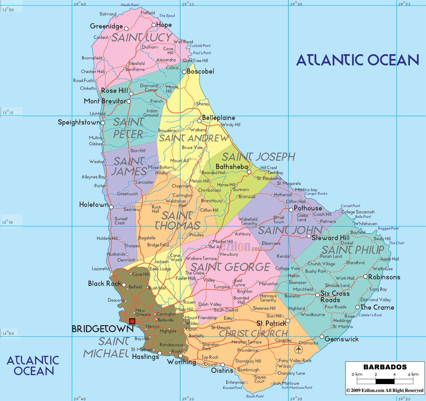
Description: Detailed large political map of Barbados showing names of capital city, towns, states, provinces and boundaries with neighbouring countries.

This map of Barbados is a practical locator. It shows all 11 parishes, the capital city, named towns and villages, parish borders, and a road-light network so you can follow the central coast and interior spines without clutter. The island sits in the Atlantic Ocean on the eastern fringe of the Caribbean region, which is why the word Atlantic appears on both the east side and southwest corner of the map.
The parishes are easy to recognize by color blocks. Starting at the capital and moving clockwise, you will see Saint Michael with Bridgetown, then Saint James, Saint Peter, Saint Lucy, Saint Andrew, Saint Joseph, Saint John, Saint Philip, Christ Church, Saint George, and Saint Thomas in the interior. The bold names printed in each parish are the best anchors when you speak with a traveler by phone or when you match a location in a guide to its place on this map.
Barbados is an island country in the Lesser Antilles. The capital, Bridgetown, sits on the southwest coast of Carlisle Bay. On our map above, Bridgetown is the largest label on the southwest corner of the island.
Barbados stands alone on the Atlantic edge of the Caribbean. Saint Lucia and Saint Vincent and the Grenadines lie to the west across the open sea. The Caribbean Sea washes the western coast, and the open Atlantic Ocean meets the eastern shore. The island’s highest point is Mount Hillaby in Saint Andrew.
Barbados has 11 parishes. Learning these names makes scanning any Barbados map fast: Christ Church, Saint Philip, Saint John, Saint Joseph, Saint Andrew, Saint Peter, Saint James, Saint Thomas, Saint George, Saint Michael, Saint Lucy.
Parish borders form the internal lines on the map. Prominent town names appear along the coasts and at a few inland junctions.
Bridgetown (Saint Michael): capital, deep-water harbor, historic core around Careenage and Garrison.
Oistins (Christ Church): a south coast fishing town and weekend food market.
Saint Lawrence Gap and Worthing (Christ Church): south coast hotel and beach strip.
Holetown and Paynes Bay (Saint James): west coast resort area.
Speightstown and Six Men’s (Saint Peter): north west coastal towns.
Mullins and Gibbes (Saint Peter): small west coast bays.
Bathsheba and Cattlewash (Saint Joseph): Atlantic surf villages on the rugged east coast.
Belleplaine (Saint Andrew): inland gateway to the Scotland District.
Six Roads and Crane (Saint Philip): east and southeast junction and cliff top beaches.
Warrens (Saint Michael): inland business district north of Bridgetown.
Harrison’s Cave and Welchman Hall Gully (Saint Thomas): central attractions shown inland on many island maps.
Checker Hall and Nesfield (Saint Lucy): far north settlements.
West Coast: calm water and pocket beaches from Bridgetown up through Holetown to Speightstown.
South Coast: lively beaches and boardwalk from Hastings to Rockley and Oistins.
East Coast: wild Atlantic shore at Bathsheba and Cattlewash, with long swells and dramatic rock.
Interior: the Scotland District in Saint Andrew and Saint Joseph has folded hills and viewpoints; Mount Hillaby crowns the island.
A road-light map shows the island’s skeleton routes without heavy numbering. Use these town chains to follow the shape:
Coastal west run: Bridgetown → Holetown → Speightstown → Six Men’s.
Coastal south run: Bridgetown → Hastings → Rockley → Saint Lawrence Gap → Oistins → Silver Sands.
Atlantic arc: Crane and Bottom Bay in Saint Philip → north through Bath, Bathsheba, and Cattlewash → inland to Belleplaine.
Cross island link: Oistins or Bridgetown inland through Warrens and Harrison’s Cave, then out toward Bathsheba.
North loop: Speightstown inland to Boscobel and Belleplaine, then back down toward Saint Thomas and Warrens.
These strings match what you see on most general maps and help visitors plan simple loops.
Grantley Adams International Airport (BGI) sits in Christ Church near Seawell on the southeast side of the island.
Bridgetown Deep Water Harbour is the cruise and cargo port just northwest of the capital core.
Port St. Charles in Saint Peter serves yachts and small craft.
Inter-island travel is mostly by air. Seasonal or private ferries may appear on charts, but scheduled public ferries are limited.
Language: English is the official language. Bajan Creole is widely spoken.
Currency: Barbados dollar (BBD) with a long-standing peg of 2 BBD to 1 USD.
Time zone: UTC minus 4 hours year-round.
Driving: left side of the road. Roundabouts and narrow lanes appear inland.
Power: 110 to 120 V at 50 Hz, plug types A and B are common. Many hotels also offer Type G outlets. Carry a universal adapter.
Calling code: +1 246.
Emergency: 211 police, 311 fire, 511 ambulance.
Tropical climate with a drier season from about December to May and a wetter season from June to November. Hurricane risk is highest from August to October. On the Atlantic side, swimming can be rough; follow local flags and advice. Inland roads in the Scotland District can be steep, so drive carefully after heavy rain.
Fix the capital, Bridgetown, on Carlisle Bay to anchor the southwest.
Trace the west coast ribbon from Holetown to Speightstown for calm beaches.
Mark Oistins and Saint Lawrence Gap to navigate the south coast.
Use Bathsheba and Cattlewash to picture the east coast line.
Add Mount Hillaby and Harrison’s Cave to visualize the hilly center.
The square red symbol marks Bridgetown, the national capital, set within Saint Michael on the southwest coastline. Surrounding labels help with orientation. To the northwest of the capital, you see Black Rock. Immediately south and east of the capital, the map prints small districts such as Bayville and Deacons. Think of Bridgetown as the hinge of two main coast corridors. One corridor runs up the calm west coast toward Holetown and Speightstown, and one runs along the busier south coast through Hastings, Worthing, and Oistins.
The parish of Saint Michael meets Saint James on the northwest boundary and Christ Church on the southeast boundary. Inland, it meets Saint George and Saint Thomas. These short boundary lines explain why the capital has quick inland links to the center of the island as well as to both coasts.
North of Saint Michael, the coastline enters Saint James, where Holetown appears on the map. This is a key resort and service town. A coastal road links Holetown back to Bridgetown and forward to Speightstown. Interior names such as Greenwich and Rock Hall sit inside Saint James and Saint Thomas, showing how the inland ridge sits close to this coast.
Continuing up the coast, the map prints Speightstown in Saint Peter. This town marks the old northern port and a clear turning point if you are driving the west coast. A little inland, you will see Mont Brevitor and Rose Hill, which are good markers when you take the cross-island roads from Speightstown toward Welchman Hall and the interior parishes.
At the top of the island, the map places Saint Lucy with Greenidge and Hope near the headland. This is the island’s true north. Small lanes circle sea cliffs and join the east and west arterial roads. When you stand at the north point, you can choose to descend the eastern side into Saint Andrew or return along the calm west to Speightstown.
Dropping down the northeast edge, the map shows Saint Andrew with Belleplaine inland from the coast and Boscobel at the parish’s southeast corner near the border with Saint Peter. This is a rugged Atlantic shore. The road hugs the foothills and gives access to dramatic beaches and the green highlands that sweep into the central parishes.
South of Saint Andrew lies Saint Joseph, and the large white label Bathsheba sits on the shoreline. Bathsheba is the best-known East Coast village on the map. From here, a coastal route continues south into Saint John, while an inland road rises west toward Saint Thomas and Saint George.
Continuing along the Atlantic side, Saint John appears with Pothouse clearly printed inland from the reef line. Parish edges here connect inland to Market Hill, Turnpike, and other Saint George settlements, which makes Saint John a natural link between the coast and the agricultural interior.
The broad southeast is Saint Philip. On this map, three labels matter most. Six Cross Roads sits in the center as the principal junction town. The Crane appears on the southeast cliff top near the famous beach. Gemswick lies on the lower east coast near the peninsula tip. From Six Cross Roads, you can branch west toward Oistins or north toward Bathsheba, which is why many directions from locals use the phrase go through Six Cross Roads.
Turning the corner from Saint Philip into Christ Church, the road-light line follows beaches and small bays. Oistins appears first on the map and serves as the fishing town and southern hub. Moving west, you pass Worthing and then Hastings. These names match bus stops and hotel districts, which is why they are printed at this scale. The same south coast corridor keeps going straight into Bridgetown, where Saint Michael begins again.
The most significant interior block is Saint George. The map prints a series of settlements that form a north-to-south arc. Market Hill anchors the north side near the line with Saint John and Saint Andrew. Further south, you meet Dash Valley, The Glebe, Walkers Terrace, and Newbury. This string shows you how to cross from east to west away from the coast. Roads here link back to Bridgetown, over to Six Cross Roads, and up to Welchman Hall.
Northwest of Saint George, the map shows Saint Thomas. Two labels stand out. Welchman Hall sits near the high central ridge and works as a junction toward Bathsheba or Speightstown. Bridge Field lies to the southwest, closer to Saint Michael, and hints at the fast link back to the capital.
Below is a compact parish locator using the exact names you see on the map. Read it like the face of a clock, starting at the capital.
Saint Michael. Capital: Bridgetown on the southwest coast. Neighbors: Saint James, Christ Church, Saint George, Saint Thomas. Nearby labels: Black Rock, Bayville, Deacons.
Saint James. West coast parish with Holetown. Interior names include Greenwich and Rock Hall near the ridge.
Saint Peter. West to northwest coast with Speightstown and inland Mont Brevitor, Rose Hill. Borders Saint Andrew and Saint Lucy.
Saint Lucy. Northern tip with Greenidge and Hope.
Saint Andrew. Northeast Atlantic side with Belleplaine and Boscobel near the south edge.
Saint Joseph. East coast heart with Bathsheba.
Saint John. East to southeast interior-coast mix with Pothouse.
Saint Philip. Southeast corner with Six Cross Roads, The Crane, Gemswick.
Christ Church. South coast with Oistins, Worthing, Hastings. Touches Saint Michael, Saint Philip, and Saint George.
Saint George. Central interior with Market Hill, Dash Valley, The Glebe, Walkers Terrace, Newbury, and Turnpike.
Saint Thomas. Interior high ground with Welchman Hall and Bridge Field connecting to both coasts.
Use Bridgetown as the starting reference. Choose the west coast for the most leisurely northbound drive to Holetown and Speightstown. Take the north circuit to reach Saint Lucy and then the dramatic east coast between Belleplaine and Bathsheba. For a southbound day, use Six Cross Roads as the pivot to The Crane, then follow the south coast through Oistins and back to the capital. When crossing inland, look for Welchman Hall and Market Hill; these names point to the high ground and the quickest routes across the island.

Physical Map of Barbados
Physical map and map image of Barbados.

Regional Directory of Caribbean
Information and guide about Caribbean and website listing.

Regional Directory of United States of America
Information and guide about United States of America and websites with American topics.

Regional Directory of Europe
Information and guide about Europe and websites with European topics.

Regional Directory of Australia
Information and guide about Australia and websites with Australian topics.