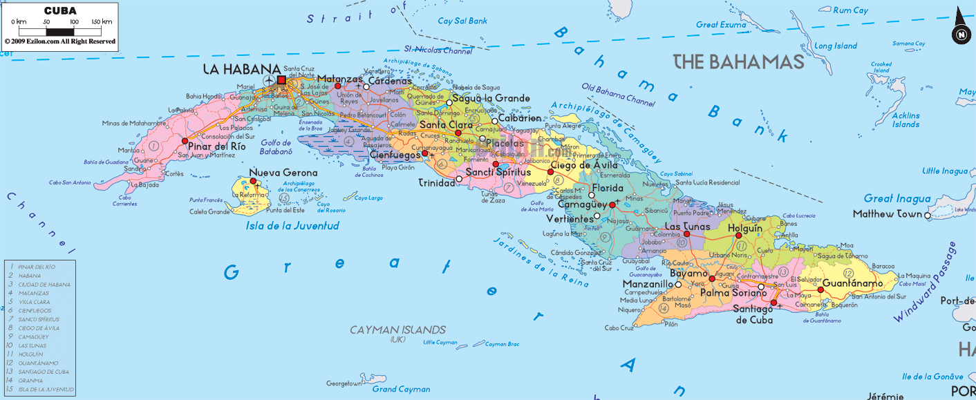
Description: Detailed large political map of Cuba showing names of capital city, towns, states, provinces and boundaries with neighbouring countries.
 Map of Cuba, featuring cities, major cities, provinces, and a road network. This straightforward guide helps you read the labels exactly as they appear on the map so you can find places fast. Cuba stretches like a long arc from the Gulf of Mexico toward the Windward Passage, with the Straits of Florida and the Bahamas to the north and the Caribbean Sea to the south. A red road-light spine links the western tip near Cabo San Antonio to the eastern end beyond Santiago de Cuba and Guantánamo.
Provinces are shaded in different colors. Names appear in large caps like PINAR DEL RÍO, MATANZAS, VILLA CLARA.
Capitals and key cities are printed with white dots and clear labels such as Pinar del Río, La Habana, Santa Clara, and Camagüey.
Seas, channels, and banks surround the island. You will see Golfo de Batabanó, Old Bahama Channel, and Bahama Bank.
Road-light lines show the main corridors that connect one province to the next.
At the far west, the province of Pinar del Río fills the map with coastal names like Cabo San Antonio, Cabo Corrientes, La Bajada, and Bahía de Guadiana. The capital city, Pinar del Río, sits inland east of the peninsula. You can follow the road-light east through La Palma and San Cristóbal toward the region labeled La Habana.
Just below this western section, you see Isla de la Juventud. The island shows Nueva Gerona as its main town, with La Fe and Reforma as small settlements. The coast reads Punta del Este and Caleta Grande. The blue caption Golfo de Batabanó fills the shallow waters between the main island and Isla de la Juventud.
Moving east, the map writes LA HABANA across the north coast. The red square marks the national capital, La Habana. Around the capital, you can spot coastal suburbs and towns like Santa Cruz del Norte to the east.
From Pinar del Río, the highway runs into La Habana and then spreads east toward Matanzas and south toward Güines and Jagüey Grande. This is the central hinge of the island where most long trips begin.
East of the capital, the label MATANZAS appears. The city of Matanzas sits on a deep coastal inlet. Further east, the town of Cárdenas stands out on the north shore. On the south side of the province, the road passes Jagüey Grande near the wetlands that lead to the Golfo de Batabanó.
The next color band reads VILLA CLARA. The large inland city of Santa Clara is easy to find near the center. On the north coast, you will see Sagua la Grande.
Just to the south and west, the smaller province of CIENFUEGOS hugs the Caribbean. The city of Cienfuegos sits deep within a well-shaped bay. The corridor runs from Santa Clara down to Cienfuegos, then east toward Sancti Spíritus.
In the central belt, the province of Sancti Spíritus covers both the city of Sancti Spíritus and the famous coastal town of Trinidad. Trinidad lies south by the sea, while Sancti Spíritus sits inland on the main road.
East of Sancti Spíritus you reach CIEGO DE ÁVILA. The city of Ciego de Ávila lies on the highway with Morón to the north, beyond salt flats and cays. The north coast is part of the Archipiélago de Camagüey, a chain of small islands strung along the turquoise shelf.
The largest province by area is CAMAGÜEY—the city of Camagüey anchors the middle with nearby towns Florida and Vertientes on the main line. The coast is low and dotted with lagoons and keys that the map groups as the Archipiélago de Camagüey.
Next comes LAS TUNAS, with the city of Las Tunas set slightly inland. After that, you enter HOLGUÍN, where the town Holguín shows up near Gibara on the coast. The dotted line offshore reads Old Bahama Channel on the north side of the island.
The province GRANMA holds the cities of Bayamo and Manzanillo. The road-light reaches Bayamo and continues to Santiago de Cuba. The south coast feels more rugged and is shown with a curved shoreline and short rivers.
The city of Santiago de Cuba is a significant marker on the south shore. East of it, you enter GUANTÁNAMO, with the town labeled Guantánamo and the large coastal indentation known worldwide as Guantánamo Bay. The fine red corridor continues to the tip near Baracoa in some editions. In this map, the far east is framed by sea labels, Windward Passage, and Old Bahama Channel.
North of Cuba, you read the Straits of Florida, the Bahama Bank, and the Old Bahama Channel. Across these waters lie Florida and the Bahamas.
South of Cuba, you see the Caribbean Sea. Further south on the sheet, you may notice the Cayman Islands in the open water.
East of Cuba, the Windward Passage leads to Haiti.
Cuba has no land borders. All boundaries are coastlines that meet these seas and channels.
Start at Cabo San Antonio in Pinar del Río.
Move east through Pinar del Río city, then on to La Habana.
Continue to Matanzas and Cárdenas on the north shore.
Cross Santa Clara in Villa Clara and drop south to Cienfuegos.
Return to the main line at Sancti Spíritus and Trinidad.
Drive through Ciego de Ávila, Camagüey, Florida, and Vertientes.
Step into Las Tunas and Holguín.
Turn south to Bayamo, Manzanillo, then reach Santiago de Cuba and finally Guantánamo.
Country. Republic of Cuba.
Capital. La Habana on the north coast.
Official language. Spanish.
Money. Cuban peso.
Time zone. UTC minus 5 hours with summer time in most years.
Air gateways. La Habana, Santiago de Cuba, Holguín, Camagüey, Santa Clara.
Climate. Tropical with a dry season roughly from November to April. Hurricane season is often from June to November.
Driving. Right side of the road.
How to use the map. Follow the red road-light from province to province, watch for coastal names like Golfo de Batabanó and Old Bahama Channel, and match city dots to the province shading for quick location checks.

Physical Map of Cuba
Physical map and map image of Cuba.

Regional Directory of Caribbean
Information and guide about Caribbean and website listing.

Regional Directory of United States of America
Information and guide about United States of America and websites with American topics.

Regional Directory of Europe
Information and guide about Europe and websites with European topics.

Regional Directory of Australia
Information and guide about Australia and websites with Australian topics.