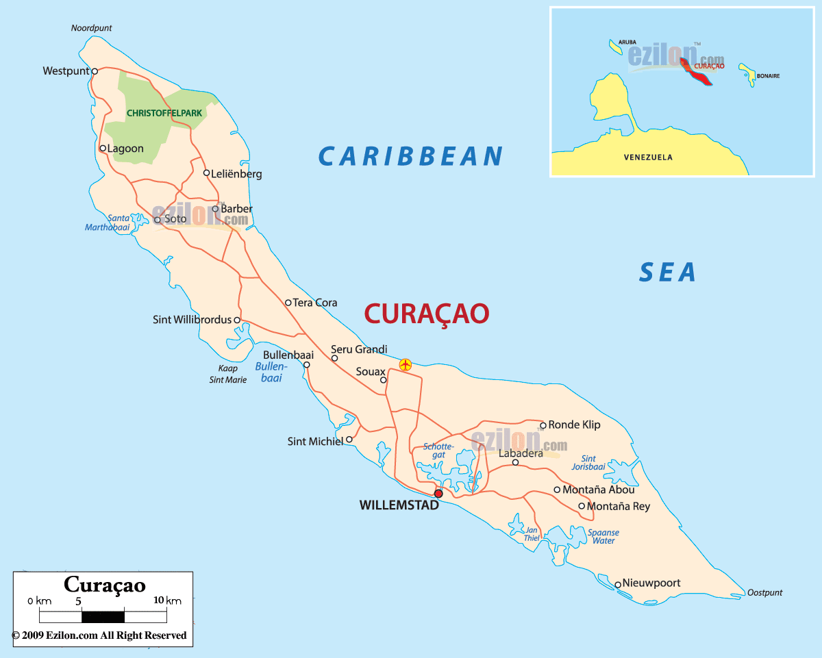
Description: Detailed large political map of Curacao showing names of capital city, cities, islands, towns, states, provinces and boundaries with neighbouring countries.
 Map of Curaçao, Curaçao map with cities, major cities, districts, and road network. Use this simple guide to find places on the island the way they are labeled on the map. Curaçao sits in the Caribbean Sea just off the coast of Venezuela. The island stretches from the rugged northwest near Westpunt and Noordpunt to the quieter far east at Oostpunt. A clear road-light corridor runs down the island’s spine and around the south coast into Willemstad, the capital.
Place names are written exactly as they appear, for quick search and matching.
The coast features numerous blue labels for bays, including Santa Martha Bay, Bullenbaai, Schottegat Lagoon, Sint Michiel, Sint Jorisbaai, Spaanse Water, and Jan Thiel.
Parks and natural areas are shaded, for example, CHRISTOFFELPARK near Westpunt.
A red road-light line marks the main corridor that links towns from northwest to southeast.
Country. Curaçao is a constituent country of the Kingdom of the Netherlands.
Capital. Willemstad on the south coast, wrapped around Schottegat.
Language. Papiamentu, Dutch, English, and Spanish are widely understood.
Money. Netherlands Antillean guilder.
Time zone. UTC minus 4 hours, year-round.
Getting in. The airport icon near Seru Grandi points to the main international gateway.
Driving. Right side of the road. Distances are short, but curves can be tight in the west.
Map tips. Watch the red road-light spine, match bays like Bullenbaai, Spaanse Water, and Sint Jorisbaai, then use town names to keep your place.
At the very top left of the map, you see Westpunt and Noordpunt. The green area labeled CHRISTOFFELPARK covers the high hills behind them. Close by are Lagoon on the west coast and Soto, a little farther south. The bay label Santa Martha baai sits on the shoreline southwest of Lagoon. This whole corner is the wild side of the island, and the road-light turns south here before bending toward the center.
As you travel south along the west coast, the map shows Sint Willibrordus near the famous pink church. Just below it is Kaap Sint Marie at the north edge of Bullenbaai. The label Bullenbaai marks a vast, blue open bay that is easy to spot on the southwest shoreline.
Moving inland from the coast, the road-light reaches Barber, Leliënberg, and Tera Cora. East of the corridor, you can find Seru Grandi and Souax. The yellow air symbol near Seru Grandi marks the island’s main airport area along this central belt. These names help you keep track while crossing from the wild northwest toward the busy south coast.
The capital, Willemstad, sits in bold type on the south coast. Right above it, you will see a large blue lagoon named Schottegat, which is the deep natural harbor at the center of the city. On the west side of Schottegat, the map prints Sint Michiel on the coast. The road-light wraps around Schottegat and guides all traffic into the city’s districts.
Past Willemstad, the road lights continue through Labadera and Ronde Klip toward the island’s northeast. A little inland, the labels Montaña Abou and Montaña Rey sit on the hills that overlook the south shore. These are good mid-island anchors if you are scanning the map to match place names to the landscape.
The southeast corner is full of calm water coves. The map clearly prints Spaanse Water, a protected lagoon with channels to the sea, and the resort area of Jan Thiel just to its south. Following the curve toward the tip, you reach Nieuwpoort on the inlet and then the very end at Oostpunt. These labels help you see how the shoreline bends from the city to the eastern point.
On the north-eastern shore, the label Sint Jorisbaai marks a long, narrow bay. From here, you can follow minor roads back toward Ronde Klip or cut south again to Jan Thiel and Spaanse Water, which brings you back to Willemstad along the coast.
The small locator inset shows ARUBA, CURAÇAO, and BONAIRE lined up just off Venezuela. Curaçao does not share land borders. All boundaries are coastlines that meet the Caribbean Sea.
Start at Westpunt near CHRISTOFFELPARK.
Drive past Lagoon and Soto to Sint Willibrordus and Bullenbaai.
Cross the middle through Barber, Leliënberg, Tera Cora, Seru Grandi, and Souax.
Enter Willemstad and circle Schottegat.
Continue east to Labadera, Ronde Klip, Montaña Abou, Montaña Rey, Spaanse Water, and Jan Thiel.
Finish at Nieuwpoort and Oostpunt.

Regional Directory of Caribbean
Information and guide about Caribbean and website listing.

Regional Directory of Canada
Information and guide about Canada and website listing.

Regional Directory of United States of America
Information and guide about United States of America and websites with American topics.

Regional Directory of Europe
Information and guide about Europe and websites with European topics.

Regional Directory of Australia
Information and guide about Australia and websites with Australian topics.