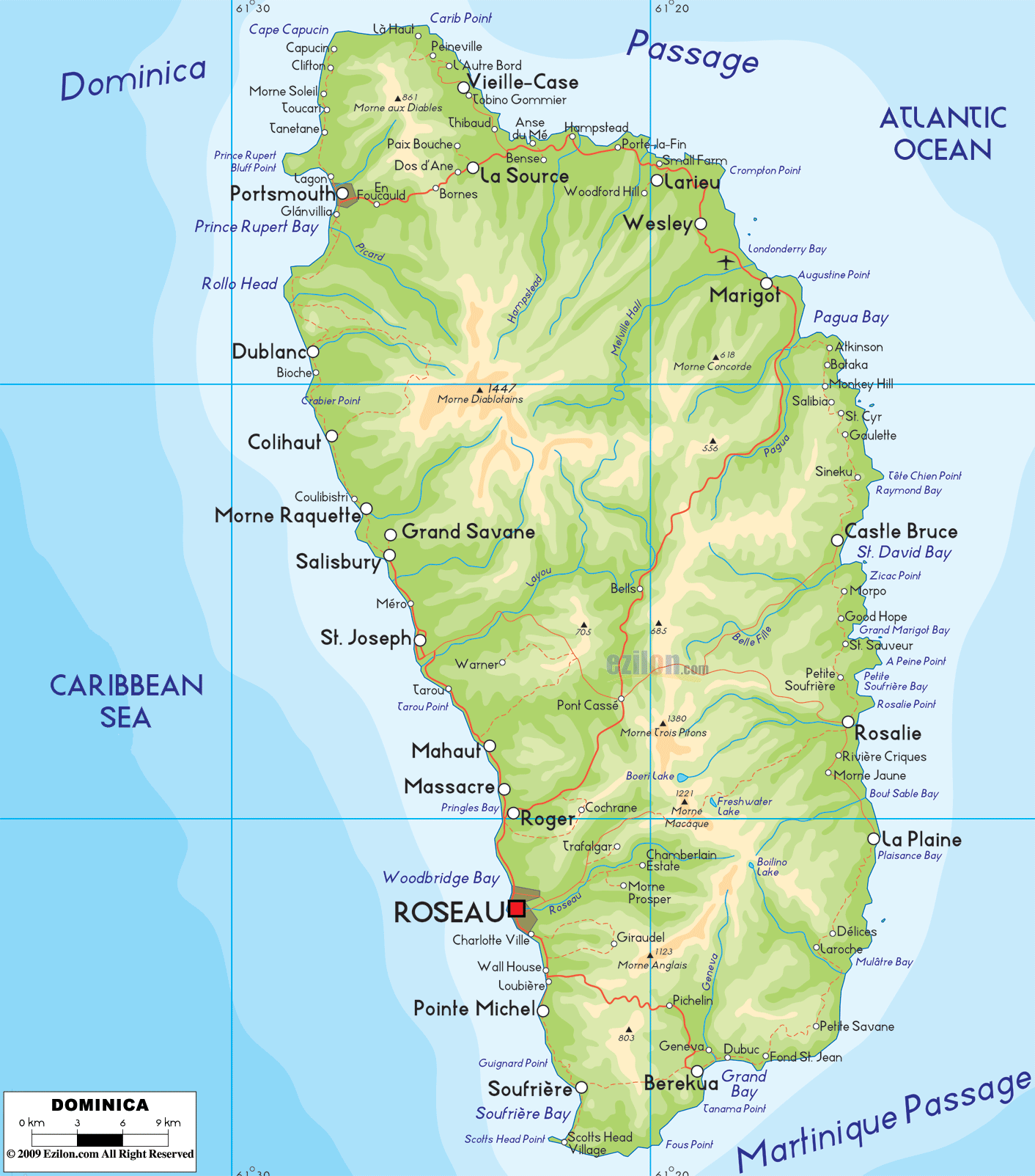
Description: The Physical Map of Dominica showing major geographical features like elevations, mountain ranges, ocean, lakes, plateaus, peninsulas, rivers, plains, landforms and other topographic features.
 Physical map of Dominica, Dominica map with mountains, rivers, valleys, coasts, and road-light network. This guide is written for quick place finding. It follows the labels printed on the map from north to south and from the west coast to the east coast. Dominica sits in the Lesser Antilles between Guadeloupe to the north and Martinique to the south. The Caribbean Sea is on the west side, and the Atlantic Ocean is on the east side. There are no land borders. Every boundary you see is a coastline.
Green and tan show hills and mountains.
Blue labels mark rivers, lakes, bays, and the sea.
The red road-light lines suggest the main driving corridors that wrap around the coast and cross the interior.
Town names help you anchor features, even on a physical map.
Island type. Young volcanic island with steep peaks and deep valleys.
The highest mountain. Morne Diablotins is about 1,447 meters.
Second peak. Morne Trois Pitons is about 1,342 meters high with crater lakes.
Main lakes. Boiling Lake, Freshwater Lake, Boeri Lake.
Longest river. Layou River.
Capital city. Roseau is on the south-west coast at the mouth of the Roseau River.
Largest bay. Prince Rupert Bay at Portsmouth.
Hot spring zone. Soufrière and Scotts Head in the south-west.
Interior crossroads. Pont Cassé.
Coasts. The west side has calmer Caribbean water. The east side faces open Atlantic waves.
Nearby islands. Guadeloupe north. Martinique south.
Driving tip. Use the coast ring road and plan extra time for mountain crossings.
The tallest mountain is Morne Diablotins at about 1,447 meters. It sits in the north-central interior. Trails climb through cloud forest to the summit. Streams flow in all directions from its slopes.
On the coast below the mountain, you will see Capuchin, Pennville, and Vieille Case on the windward side of the north. To the west, near calmer water, look for Tanetane and Penville above Prince Rupert Bay. These names help you lock the top edge of the map.
Prince Rupert Bay is the broad blue curve on the north-west coast. At the south end of the bay sits Portsmouth. The short Indian River flows into the bay just south of town. This whole area is flat compared to the interior, which is why the bay is a safe anchorage.
The Layou River is the longest. It begins near the central ridge and runs west through a deep valley to the Caribbean Sea. On the coast at the river mouth, you will find Layou village. South along the coast, you meet Mero, St. Joseph, and Massacre.
The capital, Roseau, sits on a short river called the Roseau River. It flows from the interior down to the sea between steep walls. On the map, the city spreads along the coast with Canefield to the north and Loubiere to the south. Offshore is the broad curve of the Roseau Bay coastline.
East of Roseau, the land rises quickly to the volcanic center called Morne Trois Pitons at about 1,342 meters. Within this protected area are three famous crater lakes. Boiling Lake sits in a steaming basin. Freshwater Lake and Boeri Lake lie on the high plateau. Waterfalls such as Trafalgar Falls and Middleham Falls drop from the ridges into narrow valleys. These features are clustered near the road junction of Laudat and the interior crossroads at Pont Cassé.
From Morne Trois Pitons, short rivers run west to the Caribbean and east to the Atlantic. To the west go the Roseau River and the Morne Prosper River. To the east go the Rosalie River, Pagua River, and Castle Bruce River. On the map, you can trace each blue line from the peaks to the coast.
The East Coast faces the Atlantic Ocean. It is more rugged, with rocky points and pocket beaches. In the north-east, look for Hampstead Bay and Woodford Hill. Farther south, the coast bends past Marigot, the Pagua River mouth, and Wesley near the island’s airport area. The shoreline continues to Castle Bruce, Good Hope, and Rosalie.
Between Castle Bruce and Pagua lies the Kalinago Territory along cliffs and river valleys. On the physical map, it appears as a ribbon of steep land above the ocean. Villages such as Salybia sit near river mouths that cut through the ridge.
The south-east corner is a chain of volcanic hills with hot springs near Soufrière and Scotts Head on the south-west tip. The map shows Soufrière Bay cupped by slopes that drop into the sea. This is where the Caribbean and Atlantic waters meet at a narrow neck.
A near-continuous coastal road loops the island. It connects Portsmouth to Roseau along the west and then up the east side past Grand Bay, La Plaine, Rosalie, Castle Bruce, Marigot, and Wesley. Two main interior crossings are easy to spot. One climbs from Roseau up to Laudat and the lakes. The other reaches the central junction at Pont Cassé, then drops to the east coast near Rosalie or Marigot. These lines help you plan safe routes across steep terrain.
There are no land neighbors. The blue channels around Dominica link it to the rest of the Lesser Antilles. Guadeloupe is to the north across a short sea passage. Martinique is to the south across the Dominica Channel. To the west, the island opens to the Caribbean Sea. To the east, it faces the Atlantic Ocean.

Regional Directory of Caribbean
Information and guide about Caribbean and website listing.

Regional Directory of Canada
Information and guide about Canada and website listing.

Regional Directory of United States of America
Information and guide about United States of America and websites with American topics.

Regional Directory of Europe
Information and guide about Europe and websites with European topics.

Regional Directory of Australia
Information and guide about Australia and websites with Australian topics.