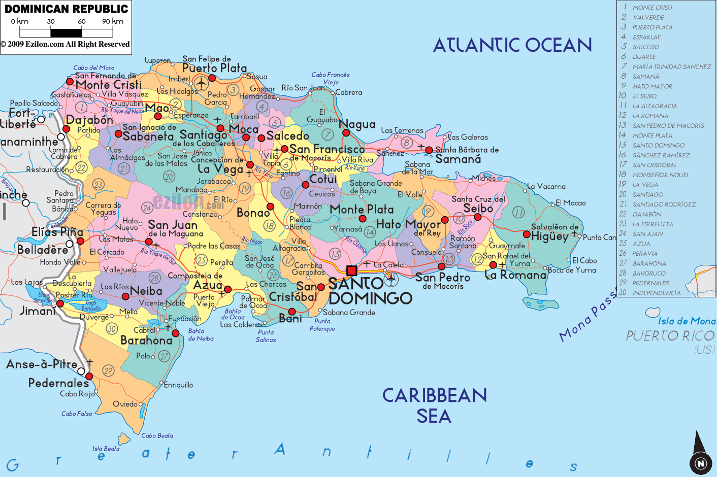
Description: Detailed large political map of Dominican Republic showing names of capital city, towns, states, provinces and boundaries with neighbouring countries.
 Map of Dominican Republic, Dominican Republic map with cities, provinces and roads network. Use this easy guide to read the labels on the map and find places fast. You are looking at the eastern side of the island of Hispaniola. The Dominican Republic borders Haiti to the west. The Atlantic Ocean is to the north. The Caribbean Sea is to the south. The Mona Passage and Puerto Rico are to the east across open water.
The capital is Santo Domingo. On the map the city is shown with a red square near the south coast. It lies at the mouth of the Ozama River and is surrounded by the Santo Domingo province. When you look for directions on the map, use Santo Domingo as the center point.
The far north-west corner shows Monte Cristi province touching the border with Haiti. The town of Monte Cristi sits under a small coastal hill. To the west the thick gray line marks the international boundary.
Moving east, you enter Dajabón and Santiago Rodríguez along the border, then the flat green Valverde plain with the city of Mao. Rivers flow north to the sea and south toward the interior. Follow the road-light lines to see how towns connect across the plain.
Farther east the coast bends to Puerto Plata. The map marks San Felipe de Puerto Plata on the shoreline and Sosúa and Cabarete nearby. These towns sit between mountains and sea. Keep going east to Gaspar Hernández, Río San Juan, and Cabrera in María Trinidad Sánchez.
South of the shoreline sits a strong row of inland cities. Santiago de los Caballeros in Santiago province is the largest city after Santo Domingo. You can see Moca in Espaillat, La Vega in La Vega province, San Francisco de Macorís in Duarte, and Salcedo in Hermanas Mirabal. These cities sit along the Cibao Valley, which the map shows with many nearby towns such as Esperanza, Navarrete, Villa González, and Bonao to the south.
At the north-east corner the map shows the Samaná Peninsula in Samaná province. The towns of Las Terrenas, Las Galeras, and Santa Bárbara de Samaná line the coast. The Bahía de Samaná is the large bay on the south side of the peninsula.
South of Nagua, the shoreline passes through Cotuí inland in Sánchez Ramírez, then the coastal towns of El Valle and Sabana de la Mar in Hato Mayor. Farther east you see El Seibo and the large province of La Altagracia. The map labels Higüey as the main city. Beaches and capes here point toward the Mona Passage. Small labels such as La Vacama, Macao, and Punta Cana help you find the far east tip.
Turning the corner to the south coast you meet La Romana province with the city of La Romana and the small offshore islands not far away. West along the coast lies San Pedro de Macorís in San Pedro de Macorís province. These two cities face the Caribbean Sea and sit on a busy road-light corridor that leads to Santo Domingo.
The brown and green interior marks the Cordillera Central mountains. The map places Constanza and Jarabacoa inside this highland area. At the foot of the range the city of Bonao in Monseñor Nouel links the mountains to the plains. La Vega sits just to the north. Cotuí in Sánchez Ramírez lies east of Bonao near the lakes and rivers that line the interior.
West of Santo Domingo you see San Cristóbal on the map. Continue west to Baní in Peravia, then Azua in Azua province. These towns sit on bays and coastal plains where the south road-light route runs close to the water.
Beyond Azua the map shows Barahona on a large bay. Inland to the north sits Neiba in Bahoruco and Jimaní in Independencia near Lake Enriquillo. At the far south-west tip is Pedernales and Cabo Rojo on the border with Haiti. This corner of the country is the most remote on the map.
The thick gray line marks the boundary with Haiti. Look for pairings such as Dajabón opposite Ouanaminthe, Comendador near Elías Piña, and Jimaní near Malpasse. The map uses roads and river lines to show how each pair connects across the frontier.
The legend lists many provinces that appear in the colored blocks. You can find Monte Cristi, Dajabón, Santiago Rodríguez, Valverde, Santiago, Puerto Plata, Espaillat, Hermanas Mirabal labeled as Salcedo, Duarte, María Trinidad Sánchez, Samaná, Hato Mayor, El Seibo, La Altagracia, La Romana, San Pedro de Macorís, Monte Plata, Santo Domingo, Sánchez Ramírez, San Cristóbal, Monseñor Nouel, La Vega, San Juan, Azua, Peravia, Barahona, Bahoruco, Independencia, and Pedernales. The Distrito Nacional is the small block around Santo Domingo itself.
The strongest inland line runs from Monte Cristi through Mao, Navarrete, Santiago, Moca, La Vega, and San Francisco de Macorís, then east to Nagua and Samaná. This is the busy Cibao corridor.
From Santo Domingo a clear route runs east to San Pedro de Macorís, La Romana, Higüey, and the east point near Punta Cana.
Another line leaves Santo Domingo and follows the coast through San Cristóbal, Baní, Azua, Barahona, and ends at Pedernales.
Cross routes climb the mountains. Examples include Santiago to Puerto Plata, La Vega to San José de Ocoa and Azua, and Bonao to Santo Domingo. These lines help you plan a trip from coast to coast.
Country. Dominican Republic on Hispaniola in the Greater Antilles.
Capital. Santo Domingo on the south coast at the Ozama River.
Second city. Santiago de los Caballeros in the Cibao Valley.
Borders. Land border with Haiti to the west. Water boundaries are the Atlantic Ocean to the north, the Caribbean Sea to the south, and the Mona Passage to Puerto Rico in the east.
Coasts. North has long Atlantic beaches and ports such as Puerto Plata. South has bays and cities such as San Pedro de Macorís, La Romana, Barahona, and Pedernales.
Provinces on the map. Colored blocks show provinces such as Monte Cristi, Valverde, Santiago, La Vega, Duarte, Samaná, Hato Mayor, El Seibo, La Altagracia, La Romana, San Pedro de Macorís, Monte Plata, Santo Domingo, San Cristóbal, Peravia, Azua, San Juan, Barahona, Bahoruco, Independencia, Pedernales, and others listed in the legend.
Travel tip. Use Santo Domingo as your hub. Follow the three main corridors. North across the Cibao. East to the Caribbean resorts. South-west along the coast to Barahona and Pedernales.

Physical Map of Dominican Republic
Physical map and map image of Dominican Republic.

Regional Directory of Caribbean
Information and guide about Caribbean and website listing.

Regional Directory of United States of America
Information and guide about United States of America and websites with American topics.

Regional Directory of Europe
Information and guide about Europe and websites with European topics.

Regional Directory of Australia
Information and guide about Australia and websites with Australian topics.