Description: Detailed large political map of Grenada showing names of capital city, towns, states, provinces and boundaries with neighbouring countries.
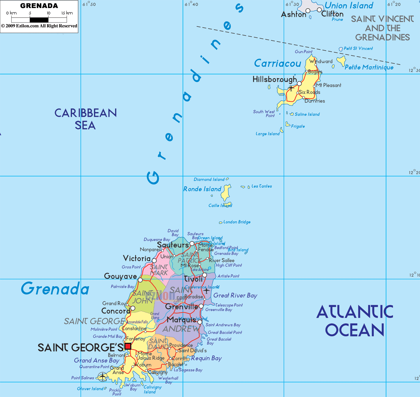
 Map of Grenada, Grenada map with cities, major cities, parishes, and the road network. This straightforward guide helps you scan the island map. You will see each parish on the main island, the offshore dependency of Carriacou and Petite Martinique, the national capital Saint George’s, the linked towns and villages, the Caribbean Sea coast to the west, the Atlantic Ocean coast to the east, and the simple road-light corridors that tie everything together.
Grenada sits at the southern end of the Grenadines chain in the Lesser Antilles. The main island is divided into six parishes, and the northern dependency is Carriacou and Petite Martinique. On the west side of the map, you meet the Caribbean Sea. On the east side, you meet the open Atlantic Ocean. To the north lie the Grenadines of Saint Vincent and the Grenadines. The easiest way to trace the island is to follow the ring road that runs around the coast and then note the short cross-island roads that climb the hills.
Country: Grenada
Capital: Saint George’s
Divisions: Six parishes on the main island and the dependency of Carriacou and Petite Martinique
Main towns: Gouyave, Victoria, Sauteurs, Grenville, Saint David’s, Grand Anse; on Carriacou, Hillsborough, Bogles, Windward, Harvey Vale; on Petite Martinique, the village of Petite Martinique
Waters: Caribbean Sea west and southwest, Atlantic Ocean east and north-east
Nearest neighbors by sea: Saint Vincent and the Grenadines to the north, Trinidad and Tobago to the southeast
Simple travel tip: Follow the coastal ring road for a whole circle drive. Use the cross-island road between Saint George’s and Grenville when you need a quick transit.
The square symbol marks Saint George’s, the national capital, tucked in a deep natural harbor on the southwest shore. On the map, you can track the coastline south from the capital to the beach suburb Grand Anse, then Belmont, Quarantine Point, and small bays that curve to Prickly Bay and Hog Island. These labels help you see the busy southwest corner where the airport sits just west of the capital.
A coastal corridor runs north from Saint George’s toward Gouyave. Another paved corridor climbs inland past the Grand Etang highlands and comes down to Grenville on the east coast. When you plan a cross-island drive, this St George’s to Grenville corridor is the one to watch on the map.
North of the capital, the coastal road reaches Gouyave, the parish center of Saint John. A little farther north, the map marks Palmiste Bay and other minor points. This coast faces the Caribbean Sea, so the water is usually calmer than on the Atlantic side.
Continuing north, you enter Saint Mark, focused on the compact town of Victoria. The parish name and the town label sit tightly together on the west shore. Watch how the road stays close to the water here with only short links inland.
The northern point of the main island is Saint Patrick. The map shows Sauteurs as the main town, plus Levera Bay, Bathway, and Bedford Point on the Atlantic side. The narrow strait north of this tip leads to the Grenadines and Union Island of Saint Vincent to the north.
West and north of the tip, the map features small islands, including Ronde Island, Caille Island, Les Tantes, Large Island, and Diamond Island. These dots help you fix the northern approach to Grenada.
Turn the corner from the north and follow the Atlantic shore southward. You are now in Saint Andrew. The largest East Coast town is Grenville, situated beside Great River Bay. To the south, you will see Marquis and Grand Bras in the inland valley. To the north of Grenville, the map points to Telescope Point and Pearls.
The most crucial cross-island road climbs from Saint George’s through the interior to Grenville. Use this line when you need to move from the Caribbean side to the Atlantic side without circling the whole coast.
South of Saint Andrew lies Saint David. The map highlights quiet coves such as La Sagesse Bay and Requin Bay, and villages like Westerhall and Saint David’s. This shore faces the Atlantic, so the coast is open and breezy. The coastal road makes a gentle curve here before turning west toward the capital.
After Saint David, the road bends around the heel of the island and returns to Saint George Parish. Villages such as Woburn, Calivigny, and the resort belt around Grand Anse fill this section. The loop closes back at Saint George’s, your main map anchor.
Look to the inset at the top right. You will see Carriacou and Petite Martinique set among the southern Grenadines. To the north, the labels Union Island and Clifton show the start of Saint Vincent and the Grenadines. This helps you understand Grenada’s sea neighborhood.
On Carriacou, the main town is Hillsborough on the west coast. Around the island, the map shows Bogles, Six Roads, Mount Pleasant, Dumfries, L’Esterre, Harvey Vale, Grand Bay, and Windward. Small islands like Saline Island, Frigate, and Large Island sit close by. The road-light line circles the island and has short spurs to beaches on both sides.
A short sail east of Carriacou lies Petite Martinique. The village label sits near the south shore. Boats from Hillsborough link these two islands every day.
Grenada is an island country, so its borders are maritime. The Caribbean Sea touches the west and southwest coasts. The Atlantic Ocean touches the east and north-east coasts. The dotted line of the Grenadines chain connects Grenada to Saint Vincent and the Grenadines to the north. Farther away to the southeast are Trinidad and Tobago, and to the southwest is the coast of Venezuela across open water.
Set Saint George’s at roughly 7 o’clock on a round clock. Moving clockwise, you reach Gouyave at 9, Victoria at 10, Sauteurs near 12, Grenville at 2, Saint David’s at 4, then back to Grand Anse and the capital at 7. This simple picture helps you locate any label fast.
Gouyave in Saint John sits north of the capital on the coastal highway.
Victoria in Saint Mark is a short drive beyond Gouyave.
Sauteurs in Saint Patrick marks the northern tip. Look for Levera Bay and Bathway just east of town.
River Sallee and Levera sit between Sauteurs and the big curve into Great River Bay.
Grenville in Saint Andrew anchors the east coast. Marquis and Grand Bras sit inland.
South of Grenville, watch for Telescope Point, Paradise, Pearls, and Grenville Vale.
Saint David’s, La Sagesse, Westerhall, Requin Bay, and Crochu line the southeast.
Grand Anse, Belmont, Woburn, Calivigny, and the harbor area of Saint George’s fill the southwest loop.
Coastal Ring Road. Circles the main island and links all parish towns. If you keep the water on one side, you cannot get lost.
St George’s to Grenville Cross-Island. Climbs through the interior and drops to the east coast. Use this when you want the shortest crossing.
Short Spurs. Local roads leave the ring to reach coves like La Sagesse Bay, Bathway, and Levera Bay.
Carriacou Circle. A loop road around Carriacou with a spur to Windward and to Hillsborough port.
To find the capital, look at the southwest harbor and read Saint George’s.
To find the central east coast town, read Grenville on Great River Bay.
For the northern approach from the Grenadines, line up Union Island, Carriacou, Petite Martinique, and Sauteurs.
For calm beaches, scan the Caribbean Sea side. For long surf, scan the Atlantic Ocean side.
For parish names, read the large all-caps labels inside each color block on the main island.

Physical Map of Grenada
Physical map and map image of Grenada.

Regional Directory of Caribbean
Information and guide about Caribbean and website listing.

Regional Directory of United States of America
Information and guide about United States of America and websites with American topics.

Regional Directory of Europe
Information and guide about Europe and websites with European topics.

Regional Directory of Australia
Information and guide about Australia and websites with Australian topics.