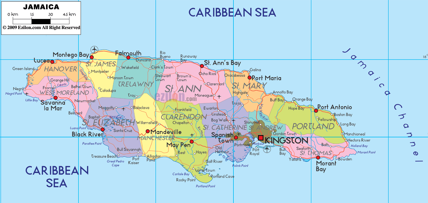
Description: Detailed large political map of Jamaica showing names of capital city, towns, states, provinces and boundaries with neighbouring countries.
 Map of Jamaica, featuring cities, major cities, parishes, and a road network. Jamaica is the third-largest island in the Caribbean. Use this easy guide to read the island at a glance. You will find the national capital, Kingston, the historic hub, Spanish Town, the north coast resort city, Montego Bay, and the east coast port, Port Antonio.
The colored blocks show Jamaica’s 14 parishes. Thin red lines show road-light corridors that connect towns along the coast and across the interior. Blue labels mark the Caribbean Sea on the west, south, and north, and the Jamaica Channel on the southeast between Jamaica and Hispaniola.
Find Kingston on the southeast, marked near Port Royal and the long sand spit called the Palisadoes.
Trace the north coast from Montego Bay to Port Antonio to see the central tourism belt.
Trace the south coast from Savanna la Mar to Morant Bay to see fishing towns, farming centers, and the coastal highway.
Look for parish names printed in large type, such as St. James, Clarendon, or Portland. Small red dots show towns. Larger red circles show bigger cities.
Norman Manley International Airport sits on the Palisadoes near Kingston.
Sangster International Airport lies just east of Montego Bay.
Ian Fleming International Airport is east of Ocho Rios near Boscobel.
Cruise and cargo ports appear at Kingston, Montego Bay, Falmouth, and Ocho Rios.
Local ferries are limited. Most intercity trips are by road or air.
Language: English is the official language. Jamaican Patois is widely spoken.
Currency: Jamaican dollar (JMD).
Time zone: UTC minus 5 hours. No daylight saving.
Driving: left side of the road. Roundabouts are common.
Power: 110 V to 120 V, 50 to 60 Hz, plug types A and B.
Calling code: +1 876 and +1 658 overlay.
Emergency: 119 for police, 110 for fire, 911 is also routed in many areas.
Tropical climate with a drier season roughly December to April and a wetter season May to November. Hurricane risk peaks late summer into autumn. Mountain roads can be narrow. Plan extra time for interior crossings.
The far northwest corner is Hanover, facing the Caribbean Sea. The parish capital is Lucea, easy to spot near Green Island and Sandy Bay. The coastal road runs east toward Montego Bay and west toward Negril Point. Small inland labels such as Hopewell and Dias mark hillside communities.
South of Hanover is Westmoreland, a broad parish with flat plains and long beaches. The chief town is Savanna la Mar on the south coast. To the west, the map marks Negril, famous for its long bay. Inland, you will notice Grange Hill, Frome, Little London, and Bluefields along the coast road that later curves toward Black River.
Black River is the parish capital, sitting at the mouth of the Black River on Jamaica’s south coast. The map also marks Santa Cruz, Lacovia, Balaclava, Malvern, and the seaside communities Treasure Beach, Parottee, and Alligator Pond. A south coast corridor connects Black River to Savanna la Mar in the west and to Mandeville and May Pen farther east.
Inland from St. Elizabeth, the cool central hills belong to Manchester. The main town is Mandeville. Other names, such as Christiana, Porus, and Newport, reveal the interior road network that leads to the south coast, near Alligator Pond and Milk River.
East of Manchester lies Clarendon with its chief town, May Pen, on the Rio Minho. The map shows Chapelton, Frankfield, Lionel Town, Rocky Point, and Hayes. A primary corridor links May Pen west to Mandeville and east to Spanish Town. Another spur heads south to Rocky Point and Milk River on the coast.
Spanish Town is clearly labeled just west of Kingston and is Jamaica’s old capital. The parish includes Old Harbour, Old Harbour Bay, Ewarton, Linstead, Bog Walk, and Hellshire Hills near Portmore. The road-light lines show several corridors: from Spanish Town west to May Pen, north to Linstead and Bog Walk, and southeast into Kingston.
The national capital, Kingston, sits on the natural harbor beside Port Royal. The map outlines suburban St. Andrew to the north, with areas such as Half-Way Tree (often depicted within Kingston), Constant Spring, Stony Hill, Gordon Town, and Papine situated on the foothills of the Blue Mountains - a ring of roads ties Kingston, Portmore, Spanish Town, and the airport at Palisadoes.
Following the coast east from Kingston, you enter St. Thomas. The parish capital, Morant Bay, is easy to find. Other towns shown are Yallahs, Bath, Seaforth, Golden Grove, Port Morant, and the island’s eastern tip at Morant Point. The coastal road hugs bays and cliffs and is the main link to Portland.
Curving north, you reach Portland, one of the greenest parishes. The main town is Port Antonio, set between East Harbour and West Harbour. Along the coast, the map lists Buff Bay, Hope Bay, Orange Bay, Boston Bay, Long Bay, and Manchioneal. Inland are hill towns like Skibo and Borders on routes to Stony Hill and Annotto Bay.
West of Portland, you enter St. Mary. The parish capital, Port Maria, lies in a sheltered bay. Other names include Annotto Bay, Highgate, Richmond, Oracabessa, and Galina. The coast road keeps close to beaches and rocky points.
Next is St. Ann, called the Garden Parish. The chief town, St. Ann’s Bay, is on the shore. The map highlights Ocho Rios, Runaway Bay, Discovery Bay, Brown’s Town, Claremont, Alexandria, and Moneague. A cross-island route runs from Ocho Rios through Moneague to Spanish Town.
Continuing west, you enter Trelawny with its capital, Falmouth, on the coast. Look for Duncans, Wakefield, Clark’s Town, and Rio Bueno near the parish border. The road follows the north shore to the next parish.
The northwestern hub, Montego Bay, is the capital of St. James. Inland towns such as Adelphi, Somerton, Maroon Town, and Catadupa climb into the hills. Along the water, the corridor carries heavy traffic toward Lucea in Hanover and Falmouth in Trelawny.
Hanover with Lucea. Westmoreland with Savanna la Mar and Negril. St. Elizabeth with Black River and Santa Cruz. Manchester with Mandeville. Clarendon with May Pen.
St. Catherine with Spanish Town, Old Harbour, Linstead, Bog Walk. Kingston and St. Andrew with Port Royal, Constant Spring, and Stony Hill.
St. Thomas with Morant Bay, Yallahs, Bath. Portland with Port Antonio, Buff Bay, and Long Bay. St. Mary with Port Maria and Annotto Bay. St. Ann with Ocho Rios and St. Ann’s Bay. Trelawny with Falmouth. St. James with Montego Bay.
The Caribbean Sea surrounds the island.
The Jamaica Channel is labeled near the southeast and separates Jamaica from Hispaniola.
North coast towns face quiet bays like Discovery Bay and Runaway Bay.
South coast towns face long beaches and fishing areas such as Rocky Point, Alligator Pond, and Treasure Beach.
The Blue Mountains rise behind Kingston and St. Andrew. Their presence explains why most roads choose the coastal plains or narrow inland passes.
North Coast Corridor from Montego Bay through Falmouth, Runaway Bay, Ocho Rios, St. Ann’s Bay, Port Maria, and Port Antonio.
South Coast Corridor from Savanna la Mar through Black River, Lacovia, Mandeville link, May Pen, Old Harbour, Spanish Town, Kingston, and east to Yallahs and Morant Bay.
Cross-Island Links like Ocho Rios to Moneague to Spanish Town, and Montego Bay to Catadupa to Santa Cruz.
Start at Kingston to fix your east side.
Sweep the north coast to Montego Bay for resorts and beaches.
Sweep the south coast to Black River and Savanna la Mar for fishing towns.
Jump inland to Mandeville, Santa Cruz, May Pen, and Spanish Town to see how the interior connects to both coasts.

Physical Map of Jamaica
Physical map and map image of Jamaica.

Regional Directory of Caribbean
Information and guide about Caribbean and website listing.

Regional Directory of United States of America
Information and guide about United States of America and websites with American topics.

Regional Directory of Europe
Information and guide about Europe and websites with European topics.

Regional Directory of Australia
Information and guide about Australia and websites with Australian topics.