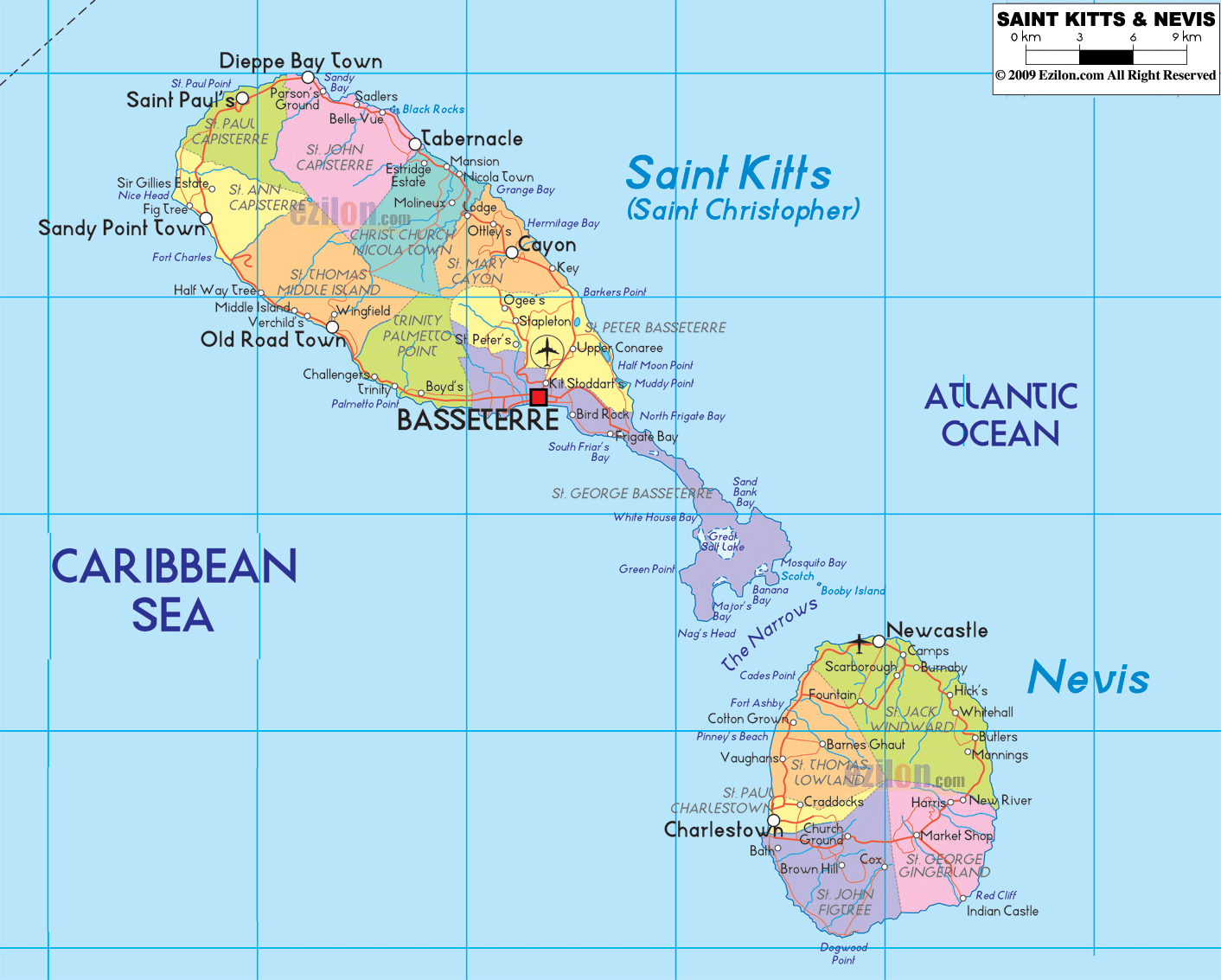
Description: Detailed large political map of Saint Kitts and Nevis showing names of capital city, towns, states, provinces and boundaries with neighbouring countries.
 Map of Saint Kitts and Nevis, with cities, parishes, and road-light network. This straightforward guide reads along the labels you see on the map so students, travelers, and residents can find places at a glance. You will see the two sister islands, Saint Kitts to the northwest and Nevis to the southeast, split by the narrow channel called The Narrows. The blue water to the west is the Caribbean Sea, and to the east is the Atlantic Ocean. Red dots mark towns, a red square marks the capital, and thin red lines show the main road-light corridors that connect communities.
The country has two islands and fourteen parishes.
Basseterre is the national capital of Saint Kitts. Charlestown is the main town on Nevis.
Place names with Saint in front are parishes. Smaller labels are towns or bays.
The ring roads loop around both islands. Side spurs run to beaches and bays.
On the far northwest coast, the map shows Sandy Point Town and Dieppe Bay Town. They sit inside Saint Anne Sandy Point Parish and Saint John Capesterre Parish. Just east of Dieppe Bay, you will see Parsons and Saddlers on the north shore. These communities face the open Atlantic and are linked by the coastal road that bends around to the northeast.
Moving east along the top of the island, the road passes Saddlers, Tabernacle, and Belle Vue within Christ Church Nichola Town Parish. Slightly inland, the label Mansion appears, and down the slope toward the sea, you will spot Lodge and Ottley. This stretch is inside Saint Mary Cayon Parish, which also includes the town of Cayon on the northeast coast.
Cayon is the key town on the east shore. From here, the road curves southeast past Keys and Conaree. Offshore on this side, the map names bays such as Half Moon Bay and North Frigate Bay. The thin red line continues to the southeast peninsula, where you can read Great Salt Pond, Banana Bay, Cockleshell Bay, Turtle Beach, and Booby Island. These labels help you place the popular beaches at the end of the island.
At the center of the south coast, the red square marks Basseterre, the national capital inside Saint George Basseterre Parish. Next to it, you will notice Bird Rock, Frigate Bay, and the suburb of Shadwell. The airport symbol sits just east of town near Conaree. West of the capital, the roadway passes Boyd's and Trinity, then reaches Old Road Town in Saint Thomas Middle Island Parish. The same road continues to Verchild's and wraps to the north shore, where our west-to-east loop began.
Saint Paul Capesterre Parish includes Dieppe Bay Town and nearby villages on the northwest rim.
Saint John Capesterre Parish lies just south of that, meeting the north coast road.
Christ Church Nichola Town Parish covers Tabernacle and Belle Vue.
Saint Mary Cayon Parish encompasses Cayon, Lodge, Ottley, and Hillside hamlets, including Mansion.
Saint Peter Basseterre Parish sits just north of the capital and touches the east.
Saint George Basseterre Parish holds Basseterre, Bird Rock, and Frigate Bay.
Trinity Palmetto Point Parish and Saint Thomas Middle Island Parish lie to the west of Boyd's, Trinity, and Old Road Town.
Saint Anne Sandy Point Parish includes Sandy Point Town at the foot of the island's western headland.
These parish names, printed in large type on the map, help you know which local government area a town belongs to. When someone says "Cayon in Saint Mary," they mean Cayon inside Saint Mary Cayon Parish on the northeast coast.
Your eye moves across The Narrows to the rounder island of Nevis. The route here is also a ring road that links each coastal village.
At the north tip, you will see Newcastle, the gateway town near the island's airport. The road bends east and southeast through Brick Kiln, Butlers, Manns, and Whitehall inside Saint James Windward Parish. On the coast near the far east, you will see New River and Indian Castle marking the island's edge.
The southeast interior is Saint George Gingerland Parish. Here, the map displays inland labels such as Zion, Market Shop, and Rice. The coast looks rugged with points and small bays, and the road climbs and dips as it connects each settlement.
On the west side, the red dot marks Charlestown, the main town of Nevis, inside Saint Paul's Charlestown Parish. Just north along the Caribbean coast, the road passes Bath, Fountain, Jessups, Barnes Ghaut, and Cotton Ground in Saint Thomas Lowland Parish. Further south from Charlestown, the map labels Brown Hill and Prospect within Saint John Figtree Parish.
Saint James Windward Parish covers Newcastle, Butlers, Brick Kiln, and the northeast coast.
Saint George's Gingerland Parish is located in the southeastern interior, with villages such as Zion and Market Shop.
Saint John Figtree Parish stretches across the south and southwest with Brown Hill and Prospect.
Saint Paul Charlestown Parish is a small district around Charlestown on the west coast.
Saint Thomas Lowland Parish runs up the northwest with Cotton Ground, Jessups, and Barnes Ghaut.
The parish borders on the map are easy to spot because each parish has its own color fill and label.
The thin label The Narrows sits between the islands. Small boats cross here, and the water shows a different shade to mark the strait.
On Saint Kitts, the south shore lists White House Bay, Ballast Bay, and Great Salt Pond.
On Nevis, the south and east label Indian Castle, New River, and Booby Island offshore.
The Caribbean Sea touches the west coasts of both islands, where you see Charlestown, Cotton Ground, Old Road Town, and Sandy Point Town.
The Atlantic Ocean meets the east coast, where you find Cayon, Keys, New River, and Butler.
If you follow the map coastlines clockwise, you can plan a complete island loop and tick off each village as you pass it.
Start at Basseterre. Go west to Boyd's, Trinity, and Old Road Town. Continue north to Sandy Point Town, then sweep around the north to Dieppe Bay Town, Saddlers, Tabernacle, and Belle Vue. Turn east to Cayon and then south to Conaree. From here, the southeast spur runs past Frigate Bay to Great Salt Pond, Banana Bay, and Cockleshell Bay. Return through Bird Rock to Basseterre to close the loop.
Begin at Charlestown. Drive north through Bath, Fountain, Jessups, and Cotton Ground to Newcastle. Curve along the northeast to Butlers and Whitehall, then down the east to New River and the Indian Castle area. Swing west again through Zion, Market Shop, and Brown Hill, then back to Charlestown.
These two loops are the main travel lines drawn in red on the map. Short spurs connect to beaches and points.
Basseterre on Saint Kitts is the national capital, marked by the red square at the south coast.
Charlestown on Nevis is the capital, shown by a red dot on the west coast.
The country is an island nation, so its borders are maritime. The map clearly names the Caribbean Sea and the Atlantic Ocean as the water neighbors of the islands. To the south, across open water, are other Lesser Antilles islands, though they are not shown in detail on this map.
Sandy Point Town, Dieppe Bay Town, Saint Anne Sandy Point Parish, Saint Paul Capesterre Parish.
Saddlers, Tabernacle, Christ Church Nichola Town Parish, Saint Mary Cayon Parish, Cayon, Keys, Ottley, Mansion.
Basseterre, Bird Rock, Frigate Bay, Shadwell, Boyd's, Trinity, Old Road Town, Verchild's.
Great Salt Pond, White House Bay, Banana Bay, Cockleshell Bay, Turtle Beach, and Booby Island offshore.
Newcastle, Brick Kiln, Butlers, Manns, Whitehall within Saint James Windward Parish.
New River, Indian Castle coast, inland Zion, and Market Shop inside Saint George Gingerland Parish.
Charlestown, Bath, Brown Hill, Prospect in Saint John Figtree Parish, and up the coast, Fountain, Jessups, Barnes Ghaut, Cotton Ground in Saint Thomas Lowland Parish.
Match parish names to towns as you memorize. Example: Cayon in Saint Mary Cayon Parish.
Learn the two capitals: Basseterre for the country and Charlestown for Nevis.
Use the ring roads to circle each island.
Note the airport symbol near Conaree on Saint Kitts and the airport area near Newcastle on Nevis.
Beaches at Frigate Bay, Banana Bay, Cockleshell Bay, Pinney's Beach near Cotton Ground, and the calm coves near Charlestown are all labeled or sit beside labeled towns.
When giving directions, pair a parish with a village. Example: "Tabernacle in Christ Church, Nichola Town."
The map's red lines show every main connector you need to plan errands across the island.
Basseterre, Sandy Point Town, Dieppe Bay Town, Old Road Town, Cayon, Saddlers, Tabernacle, Belle Vue, Mansion, Lodge, Ottley, Conaree, Boyd's, Trinity, Verchild's, Bird Rock, Frigate Bay.
Charlestown, Newcastle, Cotton Ground, Jessups, Fountain, Barnes Ghaut, Brown Hill, Prospect, Zion, Market Shop, Butlers, Brick Kiln, Whitehall, New River, Indian Castle.
The Narrows, Caribbean Sea, Atlantic Ocean, Great Salt Pond, White House Bay, North Frigate Bay, Banana Bay, Cockleshell Bay, and Booby Island.

Physical Map of Saint Kitts and Nevis
Physical map and map image of Saint Kitts and Nevis.

Regional Directory of Caribbean
Information and guide about Caribbean and website listing.

Regional Directory of United States of America
Information and guide about United States of America and websites with American topics.

Regional Directory of Europe
Information and guide about Europe and websites with European topics.

Regional Directory of Australia
Information and guide about Australia and websites with Australian topics.