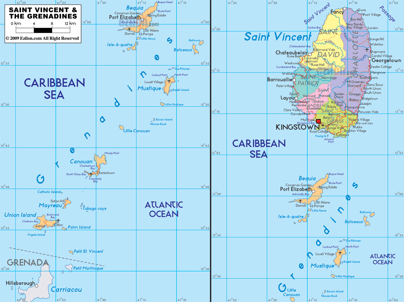
Description: Detailed clear large map of Saint Vincent and The Grenadines showing names of capital city, towns, states, provinces and boundaries with neighbouring countries.
 A map of Saint Vincent and the Grenadines, an SVG map with cities, major towns, parishes, and a simple road network, helps you find places quickly. Use this detailed map as the best map style guide to the capital, the coastal towns on Saint Vincent, and the Grenadines island chain that trails to the south.
Saint Vincent and the Grenadines is a Windward Islands nation in the eastern Caribbean. The main island is Saint Vincent with the capital Kingstown. The southern islands are the Grenadines, including Bequia, Mustique, Canouan, Mayreau, Union Island, Palm Island, and Petit St Vincent. Neighbors across the sea are Saint Lucia to the north and Grenada to the south. English is the official language, the currency is the Eastern Caribbean dollar, and the country spans about 389 square kilometers.
Saint Vincent fills the right panel of the map. The Caribbean Sea is to the west, the Atlantic Ocean is to the east, and the Saint Vincent Channel points toward Saint Lucia in the north. The chain of the Grenadines stretches down the center and left panels between the two seas.
Saint Vincent is divided into six parishes that appear in different colors.
Saint David sits at the north end of the island. It reaches up to Fancy, the last village at the tip. West coast villages here include Richmond, Petit Bordel, Troumaca, and Rose Hall. East coast names include Owia and Sandy Bay.
Charlotte runs along the northeast and east. Key towns are Georgetown on the coast, plus Colonarie, South Rivers, and Biabou down the windward road.
Saint Patrick covers the northwest above the central belt. The leeward coastal towns, Chateaubelair and Fitz Hughes, sit here.
Saint Andrew occupies the center. Use this area to cross the island through the Mesopotamia Valley.
Saint George wraps around the southwest and holds the capital Kingstown. Coastal names include Layou and Barrouallie to the northwest and Calliaqua toward the south shore.
The Grenadines parish comprises the islands to the south, including Bequia, Mustique, Canouan, Mayreau, Union Island, Palm Island, and Petit St. Vincent.
The red square marks Kingstown on the southwest coast of Saint George. The harbor is the primary ferry and cargo port and the best starting point for trips down the Grenadines.
Leeward coastal corridor. From Kingstown, head northwest along the Caribbean side. You pass Layou, Barrouallie, Keartons, Troumaca, Rose Bank, Chateaubelair, and toward Richmond.
Windward coastal corridor. From Kingstown, go east, then north along the Atlantic side. You pass Biabou, South Rivers, Colonarie, Georgetown, Sandy Bay, and Owia up to Fancy.
Cross-island connectors. From Kingstown, climb inland into Mesopotamia in Saint Andrew, then drop to either coast. These short links help you switch between the windward and leeward roads.
North. Fancy, Owia, Sandy Bay on the east, and Richmond, Petit Bordel, Troumaca, Rose Hall on the west.
West. Layou, Barrouallie, Keartons, and Chateaubelair lie up the leeward shore.
East. Biabou, South Rivers, Colonarie, and Georgetown line the windward shore.
South. Calliaqua and nearby coastal pockets sit below Kingstown.
Just south of Saint Vincent, Bequia is the largest of the northern Grenadines. The main town is Port Elizabeth on Admiralty Bay. Smaller labels include Lower Bay, Industry Bay, and Bequia Head. Two small islets, Petit Nevis and Isle a Quatre, appear nearby.
To the east, you see Baliceaux and Battowia in the Atlantic. These are uninhabited and used as sea marks on the chart.
South of Bequia is Mustique, with the village of Lovell Village in the center. The island has short coastal roads that loop back to the settlement.
Further south sits Canouan. The map marks Charlestown on the west coast and Friendship nearby. South Glossy Bay and Charlestown Bay are easy anchor points to identify.
The small island of Mayreau sits above the marine park. The map shows the Tobago Cays as a group of tiny cays and reefs between Mayreau and Petit St Vincent. Sailors use these names to plan a short hop within the chain.
Union Island is the southern hub of the parish. Clifton lies on the east side and Ashton on the southwest. Just beyond are Palm Island and Petit St Vincent, the last dots in the country before the waters of Grenada. The map also shows nearby Petit Martinique and Carriacou, both part of Grenada, for reference.
The country has sea borders with Saint Lucia in the north and Grenada in the south. The Caribbean Sea lies to the west, and the Atlantic Ocean lies to the east. Channels between islands are short and shown clearly so you can track island-to-island directions.
Official name. Saint Vincent and the Grenadines.
Capital. Kingstown on Saint Vincent.
Administrative units. Five parishes on Saint Vincent plus the Grenadines parish.
The main islands in the Grenadines. Bequia, Mustique, Canouan, Mayreau, Union Island, Palm Island, Petit St Vincent, with small islets such as Baliceaux, Battowia, Isle a Quatre, Petit Nevis.
Languages. English is the official language.
Currency. Eastern Caribbean dollar.
Neighbors across the sea. Saint Lucia north, Grenada south.
Best map use. Follow the windward and leeward coast roads on Saint Vincent, then read the island string from Bequia to Union Island.

Physical Map of St. Vincent and the Grenadines
Physical map and map image of St. Vincent and the Grenadines.

Regional Directory of Caribbean
Information and guide about Caribbean and website listing.

Regional Directory of United States of America
Information and guide about United States of America and websites with American topics.

Regional Directory of Europe
Information and guide about Europe and websites with European topics.

Regional Directory of Australia
Information and guide about Australia and websites with Australian topics.